The Museo Galileo in Florence contains one of the world’s most important collections of historic scientific instruments. Its galleries reveal how astronomy, navigation, medicine, physics, chemistry, measurement and engineering developed from the Renaissance through the 19th century.
The museum is best known for preserving Galileo Galilei’s original instruments. Visitors can see the only two surviving telescopes made by Galileo, the damaged objective lens associated with his observations of Jupiter’s moons, his geometric and military compass and several unusual personal relics.
Sponsored Popular Items
Quick take: Musement.com offers a worldwide selection of tours and attractions
Galileo Museum Private Guided Tour Italy Galileo Museum private tour is a convenient way to add structure, local context and purposeful sightseeing to the itinerary. Check current availability, inclusions and booking details before you go.
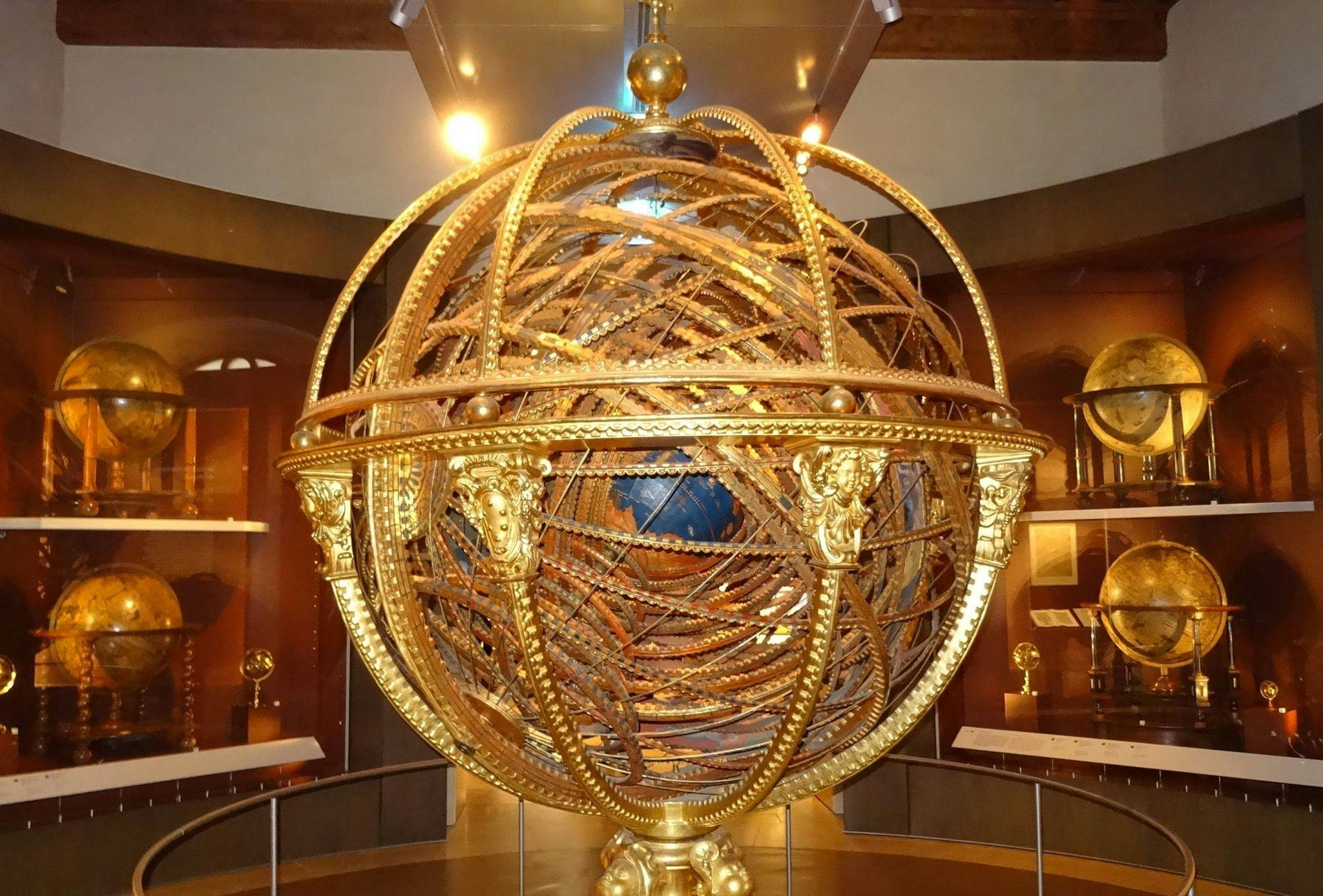
Galileo is only part of the story. The collection also includes elaborate celestial globes, astrolabes, thermometers, microscopes, mechanical clocks, electrical machines, air pumps, surveying instruments and an enormous gilded armillary sphere built for the Medici court.
The museum occupies Palazzo Castellani beside the River Arno, immediately behind the Uffizi Gallery and a short walk from Palazzo Vecchio and Ponte Vecchio. Its central location makes it easy to add to a day of sightseeing without crossing Florence.
Unlike a modern hands-on science centre, the Museo Galileo is primarily a museum of original historical objects. Its instruments are displayed as evidence of experimentation, courtly collecting, craftsmanship and changing ideas about the universe.
This guide explains what to see, current ticket prices and opening hours, how long to allow, whether the museum suits children, accessibility arrangements and how to combine it with other attractions in central Florence.
Museo Galileo Quick Facts
Visitor information
Details
Official name
Museo Galileo – Istituto e Museo di Storia della Scienza
Location
Piazza dei Giudici 1, Florence
Building
Palazzo Castellani
Main subject
History of science and scientific instruments
Best-known exhibits
Galileo’s telescopes, lens and personal relics
Current adult admission
€14
Visitors aged 6–18
€7
Children under six
Free
Current family ticket
€32
Usual opening time
9:30 am
Usual closing time
6:00 pm
Tuesday closing time
1:00 pm, except selected public holidays
Closed
1 January and 25 December
Recommended visit
One and a half to two hours
Collection floors
Two principal exhibition floors
Nearest major landmark
Uffizi Gallery
Firenze Card
Included under current conditions
Free museum app
Available for smartphones and tablets
Accessibility
All floors accessible using lifts and stairlifts
Important: Tuesday hours are considerably shorter than on other days. Avoid planning an afternoon Tuesday visit unless the date is specifically listed as having extended public-holiday hours.
What Is the Museo Galileo?
The Museo Galileo is a museum and international research institute devoted to the history of science.
Its collection consists primarily of original scientific instruments assembled by two ruling families of Tuscany:
The Medici dynasty.
The Habsburg-Lorraine grand dukes.
These objects were not collected only for practical scientific work. Many were also designed to demonstrate wealth, education, craftsmanship and intellectual authority.
An astronomical instrument made for a grand duke could therefore be:
A working measurement device.
An educational model.
A decorative court object.
A statement of political power.
Evidence of patronage of mathematics and astronomy.
The displays help explain how scientific knowledge developed through an interaction between observers, instrument makers, mathematicians, physicians, sailors, engineers and wealthy patrons.
Why Visit the Galileo Museum?
The museum provides a different experience from Florence’s famous art galleries and churches.
Reasons to visit include:
Seeing Galileo’s original telescopes.
Understanding how early astronomical observations were made.
Seeing the development of thermometers, barometers and microscopes.
Discovering early experiments in electricity and air pressure.
Exploring the relationship between navigation and astronomy.
Visiting a quieter museum close to the Uffizi.
Adding scientific history to a Renaissance-focused Florence itinerary.
The museum is particularly rewarding for visitors interested in astronomy, engineering, medicine, mathematics, navigation or the intellectual history of the Renaissance.
A Short History of the Museum
Medici Collecting
The scientific collection began during the 16th century under Cosimo I de’ Medici.
Instruments were initially displayed in the Palazzo Vecchio’s Map Room, where painted maps and cosmographical devices presented a courtly vision of the known world.
Ferdinando I later transferred important objects to a mathematics room in the Uffizi. The space contained instruments used for:
Astronomy.
Surveying.
Navigation.
Military engineering.
Timekeeping.
Mathematical calculation.
Galileo and the Medici Court
Galileo deliberately connected his scientific work with the Medici family.
After observing four moons orbiting Jupiter in 1610, he named them the Medicean Stars in honour of Grand Duke Cosimo II and his brothers.
The strategy helped secure Galileo a prestigious position as mathematician and philosopher to the Tuscan court.
His instruments, publications and observations subsequently became closely connected with the Medici scientific collection.
Accademia del Cimento
During the 17th century, Prince Leopold de’ Medici and Grand Duke Ferdinando II supported the Accademia del Cimento.
The academy promoted the experimental investigation of nature and adopted the principle of testing claims through carefully organised observation.
Its members conducted research involving:
Temperature.
Air pressure.
Vacuum.
Freezing.
Sound.
Motion.
Properties of liquids.
The Lorraine Grand Dukes
After the Medici dynasty ended, Tuscany passed to the House of Lorraine.
Grand Duke Peter Leopold reorganised scientific collecting and supported the creation of the Imperial and Royal Museum of Physics and Natural History.
The Lorraine collection expanded through instruments relating to:
Mechanics.
Electricity.
Pneumatics.
Chemistry.
Medicine.
Pharmacy.
Natural philosophy.
The Modern Museum
During the early 20th century, historians and scientists worked to protect Italy’s scientific heritage.
The permanent History of Science Museum opened in Palazzo Castellani in 1930.
The collection suffered serious damage during Florence’s 1966 flood, when water affected objects stored on lower floors. Conservation and restoration work followed.
The institution adopted the name Museo Galileo in 2010 after a major renovation and redesign of its galleries.
Palazzo Castellani
The museum occupies Palazzo Castellani, a historic stone building overlooking the River Arno.
The site has origins dating to the late 11th century and was formerly known as Castello d’Altafronte.
The building formed part of Florence’s early defensive environment near the river and city walls.
Over time, the structure changed from a fortified medieval building into an urban palace.
What to Notice Outside
The rough stone façade.
Arched lower windows.
The museum’s vertical banner.
The monumental sundial in Piazza dei Giudici.
Views towards the Arno and Uffizi.
The Monumental Sundial
A modern monumental sundial stands outside the museum.
Its gnomon casts a shadow across markings embedded in the pavement, demonstrating the connection between the Sun’s apparent movement and the measurement of time.
It provides an effective introduction to the museum because it turns the public square itself into a scientific instrument.
How the Collection Is Arranged
The permanent displays occupy two principal floors.
First Floor
The first floor concentrates on the Medici collections.
Its themes include:
Early mathematical instruments.
Cosmography.
Astronomy.
Navigation.
Military engineering.
Galileo and his observations.
The Accademia del Cimento.
Second Floor
The second floor presents instruments collected or commissioned during the Lorraine period.
Subjects include:
Electricity.
Air pressure.
Mechanics.
Timekeeping.
Chemistry.
Medicine.
Pharmacy.
Weights and measures.
The distinction between the floors helps visitors follow a broad historical transition from Renaissance court science to the increasingly public and institutional science of the 18th and 19th centuries.
The Medici Collection
The Medici collection is both scientific and artistic.
Many objects are made from brass, wood, silver, glass or gilded materials and were decorated to a standard appropriate for a royal court.
The collection includes:
Astrolabes.
Armillary spheres.
Celestial and terrestrial globes.
Sundials.
Military compasses.
Surveying instruments.
Astronomical clocks.
Galileo’s telescopes.
Experimental glassware.
Early thermometers.
Scientific instruments gave Medici rulers a way to associate their court with knowledge, order and control of the natural world.
The Lorraine Collection
The Lorraine galleries reflect a later period in which science was increasingly organised through museums, teaching collections, laboratories and public demonstrations.
The instruments include:
Electrostatic machines.
Air pumps.
Mechanical demonstration devices.
Hydraulic instruments.
Chemical apparatus.
Microscopes.
Medical instruments.
Pharmaceutical containers.
Clocks and automata.
Precision measuring devices.
Some machines were intended to produce dramatic demonstrations for students and visitors. Sparks, moving mechanisms, vacuum experiments and electrical effects made scientific principles visible.
Essential Museum Highlights
Exhibit
Why it matters
Galileo’s two telescopes
The only surviving telescopes made by Galileo
Galileo’s objective lens
Associated with his revolutionary observations of Jupiter’s moons
Galileo’s middle finger
An unusual example of his later treatment as a scientific hero
Geometric and military compass
Shows Galileo’s practical work in calculation and engineering
Galileo’s astrolabe
A Renaissance instrument used for astronomical calculation
Santucci armillary sphere
A huge gilded model of the Ptolemaic universe
Accademia del Cimento thermometers
Evidence of early systematic experimental science
Celestial globes
Show how stars and constellations were mapped
Grand Duke’s chemistry cabinet
A rare surviving court laboratory installation
Electrostatic machines
Demonstrate the experimental culture of the 18th century
Galileo’s Original Telescopes
The museum preserves the only two surviving telescopes constructed by Galileo.
They appear modest compared with modern astronomical equipment. Their wooden tubes are narrow, and their lenses provide a restricted field of view.
Galileo did not invent the telescope. Reports of a Dutch optical device reached him in 1609, and he rapidly developed improved versions with greater magnification.
What Galileo Saw
Using his telescopes, Galileo observed:
Mountains and craters on the Moon.
Large numbers of previously invisible stars.
Four moons orbiting Jupiter.
The phases of Venus.
Sunspots.
The unusual appearance of Saturn.
These observations challenged the belief that the heavens were perfect, unchanging and organised entirely around Earth.
Looking at the Instruments
Notice:
The length and narrowness of the tubes.
The decorative covering.
The small lens openings.
The absence of a modern stable mount.
The craftsmanship required to align the optics.
The instruments show how much Galileo achieved using equipment that was far less powerful than an inexpensive modern telescope.
Galileo’s Objective Lens
The museum preserves a cracked objective lens associated with Galileo’s observations of 1609 and 1610.
Galileo donated the lens to Grand Duke Cosimo II.
It is traditionally connected with the telescope used when Galileo observed Jupiter’s four largest moons.
Those moons are now known as:
Io.
Europa.
Ganymede.
Callisto.
The discovery provided visible evidence that not every celestial body orbited Earth.
Why the Lens Matters
The lens is physically small but historically exceptional.
It represents the point where:
Craftsmanship in glass met astronomy.
A new instrument expanded human vision.
Direct observation challenged established theory.
Scientific evidence became politically significant.
Galileo’s Finger and Other Relics
One of the museum’s most unexpected displays contains Galileo’s preserved middle finger.
The finger was removed in 1737 when Galileo’s remains were transferred to a new monumental tomb in the Basilica of Santa Croce.
It was preserved as a relic by admirers who viewed Galileo as a hero and martyr of science.
Other bodily relics connected with Galileo include a thumb, another finger and a tooth.
Why Was the Finger Preserved?
The practice reflects the way scientific figures could be honoured in a manner resembling the veneration of religious saints.
The display therefore reveals as much about Galileo’s later reputation as it does about his life.
Some visitors find the relic fascinating, while others find it unsettling. It remains one of Florence’s most unusual museum objects.
Galileo’s Geometric and Military Compass
Galileo developed a proportional compass used for practical mathematical calculations.
Despite its name, it was not simply a device for finding direction.
Its graduated arms could assist with:
Calculating proportions.
Determining areas and volumes.
Currency conversions.
Artillery calculations.
Scaling designs.
Engineering problems.
Galileo taught wealthy students how to use the instrument and published instructions explaining its operation.
The compass shows that his career involved commercial teaching and practical technology as well as astronomy and theoretical physics.
Galileo’s Astrolabe
An astrolabe is an instrument used to model the sky and solve problems involving time, celestial positions and latitude.
The museum’s so-called Galileo astrolabe was preserved in the Uffizi and used by Galileo for astronomical calculation.
Its components include:
A planispheric representation of the sky.
Graduated scales.
A calendar.
Zodiac markings.
A rotating sighting device.
Astrolabes required extensive mathematical knowledge but could perform many functions within one compact device.
The Santucci Armillary Sphere
The enormous armillary sphere built under Antonio Santucci’s supervision is one of the museum’s most visually spectacular objects.
Construction began in 1588 and was completed in 1593 for Grand Duke Ferdinando I de’ Medici.
The sphere represents the universe according to the geocentric system associated with Aristotle and Ptolemy.
Earth sits at the centre, surrounded by rings representing celestial circles and planetary motions.
What to Notice
The gilded wooden framework.
The concentric astronomical rings.
The central terrestrial globe.
The elaborately decorated supporting structure.
The combination of science, art and royal display.
Its geocentric arrangement may seem scientifically outdated, but the sphere accurately demonstrates an influential historical model of the cosmos.
Celestial and Terrestrial Globes
The museum contains an important collection of globes.
Terrestrial Globes
These represent geographical knowledge at the time they were produced.
Look for:
Coastlines based on incomplete exploration.
Changing names of countries and regions.
Decorative ships and sea creatures.
Areas left uncertain or incorrectly drawn.
Celestial Globes
Celestial globes map stars onto a sphere.
Constellations are often shown as elaborate figures from Greek mythology, Arabic astronomy and other traditions.
The globes demonstrate how astronomy, navigation, art and mythology were closely connected.
Accademia del Cimento Instruments
The Accademia del Cimento was founded in Florence in 1657.
Its motto, often translated as “try and try again,” expressed a commitment to experimentation.
The academy did not survive for many decades, but its work was influential.
Its instruments investigated:
Changes in temperature.
Atmospheric pressure.
Behaviour of liquids.
Freezing and expansion.
Vacuum.
Sound.
The glass devices are also beautiful examples of Florentine craftsmanship.
Early Thermometers and Barometers
Before modern standardised thermometers, researchers experimented with sealed glass tubes containing liquids.
The museum’s early thermometric instruments include:
Long glass tubes.
Spiral forms.
Multi-bulb devices.
Decorative glass arrangements.
Instruments intended to compare temperature changes.
These devices did not always use the same numerical scales, making direct comparison difficult.
The displays show that measuring temperature required the development of:
Reliable liquids.
Sealed containers.
Repeatable reference points.
Standard scales.
Carefully made glass tubes.
Microscopes and Optical Instruments
Galileo developed an early compound microscope after his work with telescopes.
The museum’s optical displays trace the use of lenses to enlarge both distant and very small objects.
Instruments may include:
Simple microscopes.
Compound microscopes.
Optical demonstration devices.
Perspective instruments.
Lenses.
Visual toys.
The development of microscopy opened new fields of investigation in anatomy, biology and medicine.
Clocks and Timekeeping
Accurate timekeeping was essential for astronomy, navigation and scientific experimentation.
The museum contains sophisticated clocks that combine:
Hours and minutes.
Calendars.
Astronomical information.
Planetary cycles.
Religious feast days.
Chiming mechanisms.
Some clocks were designed as prestigious court objects, while others supported practical observation.
Early scientists increasingly needed to measure short intervals accurately when studying motion, pendulums and falling bodies.
Navigation and Surveying Instruments
Florence was not a major seaport, but navigation remained important to its rulers, merchants and instrument makers.
The collection includes devices for:
Measuring angles.
Determining latitude.
Surveying land.
Calculating distances.
Planning fortifications.
Aiming artillery.
Mapping territory.
Look for quadrants, compasses, astrolabes, sectors and sighting instruments.
Many devices served more than one purpose. The same basic geometry could be applied to astronomy, architecture, warfare and land measurement.
Mechanical, Pneumatic and Electrical Experiments
The Lorraine galleries contain machines designed to demonstrate physical principles.
Mechanics
Mechanical models illustrate:
Gravity.
Falling bodies.
Pendulums.
Centrifugal force.
Levers.
Equilibrium.
Motion along curved paths.
Pneumatics
Air pumps allowed researchers to remove air from a container and investigate vacuum-related effects.
Experiments could examine:
Sound in reduced air.
Combustion.
Animal respiration.
Pressure.
Boiling and evaporation.
Electricity
Early electrostatic machines generated charge through friction.
Demonstrations could produce:
Sparks.
Attraction and repulsion.
Charged conductors.
Visible electrical effects.
These dramatic experiments made electricity a popular subject for court and public demonstrations.
The Grand Duke’s Chemistry Cabinet
The Lorraine collection includes a chemistry bench associated with Grand Duke Peter Leopold.
The installation contains:
A work surface.
Compartments and drawers.
Glass containers.
Mortars.
Combustion equipment.
Storage for preparations.
It provides a rare view of chemistry as practised before the modern laboratory developed.
Early chemistry combined:
Pharmacy.
Metallurgy.
Analysis of minerals.
Manufacture of pigments.
Investigation of gases.
Older alchemical traditions.
Medical and Pharmaceutical Instruments
The museum’s later collections include objects connected with medicine, surgery and pharmacy.
Possible displays include:
Surgical instruments.
Anatomical teaching material.
Pharmaceutical containers.
Measuring instruments.
Devices for diagnosis or treatment.
Some instruments may appear severe by modern standards. They demonstrate how medical practice changed alongside developments in anatomy, materials and experimental science.
The 2026 Temporary Exhibition
From 18 June to 18 October 2026, the museum is presenting Mirabilia Graphica: Micrographic Calligrams of Ignazio Muligino.
The exhibition examines an extraordinary late-17th-century calligram created using writing so small that it becomes difficult to read without optical assistance.
The microscopic script forms a religious image based on a painting associated with Pietro da Cortona.
The exhibition connects:
Calligraphy.
Microscopy.
Optical science.
Religious imagery.
Technical virtuosity.
Admission to the exhibition is included with the normal museum ticket.
Current Ticket Prices
Ticket category
Current price
Full adult admission
€14
Visitors aged 6–18
€7
Children under six
Free
Groups of at least 15
€7 per person, plus booking charge
School groups aged 6–15
€6 per student, plus booking charge
Family ticket
€32
Selected discounted categories
€10
Family Ticket
The family ticket currently covers either:
Two adults and up to two visitors aged 18 or younger.
One adult and up to three visitors aged 18 or younger.
Free Admission
Free admission may apply to eligible categories including:
Children under six.
Visitors with disabilities.
One accompanying person.
ICOM members.
Selected museum and professional cardholders.
Carry appropriate identification or documentation.
Online Booking Charge
Online and telephone reservations currently carry a service charge of €1 per ticket.
Firenze Card
The museum participates in the Firenze Card circuit under current arrangements.
Check whether the card’s activation and reservation rules fit the rest of your itinerary before purchasing it solely for this museum.
Current Opening Hours
Day
Opening hours
Monday
9:30 am–6:00 pm
Tuesday
9:30 am–1:00 pm
Wednesday
9:30 am–6:00 pm
Thursday
9:30 am–6:00 pm
Friday
9:30 am–6:00 pm
Saturday
9:30 am–6:00 pm
Sunday
9:30 am–6:00 pm
Ticket sales end 30 minutes before closing.
The museum is closed on:
1 January.
25 December.
Selected public-holiday Tuesdays may use the full 6:00 pm closing time. The current 2026 calendar lists extended Tuesday hours on 2 June and 8 December.
Do You Need to Book?
Individual visitors do not normally need an advance reservation.
Booking is still useful when:
Visiting during Easter.
Travelling in the busiest summer period.
Arriving with a strict schedule.
Visiting as a large family group.
Planning a guided tour or workshop.
Groups
Groups containing at least 15 people must reserve in advance, whether visiting independently or with a guide.
Large groups may be divided into smaller sections for safety within the galleries.
Ticket Validity
A ticket bought at the museum is valid for that day.
Online tickets are tied to the selected date, although date changes may be possible for a small administrative charge under current conditions.
How Long Should You Spend?
Time available
Realistic experience
45 minutes
Galileo rooms and the armillary sphere
One hour
Principal Medici highlights
90 minutes
Comfortable overview of both floors
Two hours
Detailed first visit
Three hours
In-depth visit using the app and videos
The museum’s official estimate is one to two hours.
Visitors with a strong interest in astronomy, engineering or antique instruments can easily spend longer.
The Best Route Through the Museum
Begin with the Medici collections on the first floor.
A logical sequence is:
Early mathematical and astronomical instruments.
Astrolabes and clocks.
Terrestrial and celestial globes.
The Santucci armillary sphere.
Surveying and military instruments.
Galileo’s telescopes and relics.
Accademia del Cimento experiments.
Lorraine physics and chemistry galleries.
This order allows visitors to see how courtly cosmography developed into an increasingly experimental and institutional scientific culture.
A One-Hour Highlights Route
When time is limited, prioritise:
The Santucci armillary sphere.
One major celestial globe.
Galileo’s geometric and military compass.
Galileo’s two telescopes.
The objective lens.
Galileo’s finger and relic display.
Accademia del Cimento thermometers.
One electrostatic machine.
The Lorraine chemistry cabinet.
Use the museum app or ask staff for the quickest route to Room VII when Galileo’s instruments are your main priority.
A Detailed Two-Hour Visit
First 30 Minutes
Explore early mathematical instruments, astronomical clocks and astrolabes.
Second 30 Minutes
Spend time with the globes and monumental armillary sphere.
Third 30 Minutes
Concentrate on Galileo’s telescopes, lens, compass, portraits and relics.
Final 30 Minutes
Visit the Accademia del Cimento instruments and selected Lorraine displays involving electricity, mechanics and chemistry.
Visitors attending the 2026 temporary exhibition should add approximately 20–30 minutes.
Museum App and Digital Guide
The museum provides a free app for smartphones and tablets.
The app highlights approximately 80 important instruments and also provides access to information about the wider collection.
Before Visiting
Download the app in advance.
Bring charged earphones.
Charge the phone fully.
Consider carrying a small power bank.
The app requires an internet connection, and free Wi-Fi is available inside the museum.
Printed Mini Guides
Downloadable mini guides are available in several languages, including English, Italian, French, Spanish, Portuguese, Chinese and Japanese.
Guided Tours
The museum offers reservable guided visits for small and large groups.
Groups of Up to 14
A 60-minute private guided service currently costs €65 in addition to each participant’s museum admission.
A €1-per-ticket reservation charge also applies.
Groups of 15 or More
Guided visits for larger groups currently cost €3 per person in addition to museum admission and the booking fee.
Why Consider a Guide?
Many instruments are difficult to understand from appearance alone.
A guide can explain:
How an astrolabe works.
What Galileo could see through his telescope.
How the Medici used science politically.
How early thermometers differed from modern ones.
What electrostatic machines demonstrated.
Visiting with Children
The Museo Galileo can appeal to children, but it is not a conventional interactive science centre.
Most displays consist of original objects inside cases.
Children May Enjoy
Galileo’s telescopes.
The enormous armillary sphere.
Globes and star maps.
Galileo’s preserved finger.
Mechanical clocks.
Electrical machines.
Videos and digital reconstructions.
Potential Difficulties
Complex historical labels.
Limited opportunities to touch objects.
Technical mathematical concepts.
Many instruments that appear similar without explanation.
The museum advises that children younger than approximately seven or eight may find an independent visit difficult to understand.
Family Strategy
Keep the visit to around one hour.
Focus on five or six memorable objects.
Use the app or a family activity.
Ask children what each instrument might measure.
Explain the preserved finger before reaching it.
Take a break beside the Arno afterwards.
Accessibility
The museum provides wheelchair access to all exhibition floors.
Accessible Entrance
The designated entrance is at Lungarno Anna Maria Luisa de’ Medici 2.
Use the intercom to request assistance from museum staff.
Mobility Facilities
Two elevators.
Two stairlifts with a maximum capacity of approximately 325 kilograms.
Accessible toilets on all floors.
A manual wheelchair available to borrow.
Free admission for an eligible visitor and one companion.
Visual Accessibility
Facilities include:
Tactile maps.
A three-dimensional model of Palazzo Castellani.
Braille and large-print guides.
Audio guidance for a tactile route.
Tactile models of selected scientific instruments.
Audible floor announcements in lifts.
Guided Tactile Tours
A guided tactile tour can be booked in advance.
The activity uses replicas and three-dimensional models to explain selected instruments.
Assistance Animals
Properly restrained guide dogs are permitted inside the museum.
Lockers and Bag Rules
Free lockers are available near the museum entrance.
Two larger locked storage containers can accommodate student backpacks and bulky bags.
Visitors should store:
Large backpacks.
Bulky shopping bags.
Umbrellas.
Items that could strike display cases.
Capacity is limited. Do not arrive with large suitcases expecting airport-style luggage storage.
Photography Rules
Visitors may take photographs inside the museum for private, non-commercial purposes.
The following are prohibited:
Flash photography.
Tripods.
Selfie sticks.
Professional filming without authorisation.
Keep cameras and phones away from display cases and avoid blocking narrow gallery routes.
Toilets, Wi-Fi and Bookshop
Toilets
Restrooms are available within the building, including accessible toilets on every floor.
Wi-Fi
Free Wi-Fi is available and is useful when operating the museum app.
Bookshop
The ground-floor shop sells:
Museum catalogues.
Books about Galileo.
Histories of science.
Educational books for children.
Guides.
Science-related gifts.
Food and Drink
The museum does not function as a major food destination. Eat before or after visiting at one of the many cafés and restaurants around Piazza della Signoria, Santa Croce or the Arno.
Getting to the Museo Galileo
The museum’s address is:
Piazza dei Giudici 1, 50122 Florence, Italy.
It is located:
Immediately behind the Uffizi Gallery.
Beside the River Arno.
Approximately five minutes from Palazzo Vecchio.
Approximately five to ten minutes from Ponte Vecchio.
Approximately 15 minutes from Florence Cathedral.
The historic centre is largely pedestrianised, so walking is the easiest method for most visitors.
Walking from Florence Station
From Firenze Santa Maria Novella station, allow approximately 20–25 minutes on foot.
A practical route passes through or near:
Piazza Santa Maria Novella.
Via de’ Cerretani or central shopping streets.
Piazza del Duomo.
Via dei Calzaiuoli.
Piazza della Signoria.
The Uffizi.
Piazza dei Giudici.
Visitors with luggage should store it at their hotel or a proper luggage facility rather than carrying it through the museum.
Arriving by Car
Do not attempt to drive directly to the entrance.
Central Florence has restricted-traffic zones monitored by cameras. Unauthorised entry can result in a fine.
Use an authorised garage outside or within the controlled zone and confirm that staff will register the vehicle correctly.
Attractions Near the Museum
Uffizi Gallery
The Uffizi stands immediately beside the museum and contains masterpieces by Botticelli, Leonardo, Michelangelo, Raphael, Titian and Caravaggio.
Combining both museums in one morning is possible but creates a demanding concentration of indoor exhibits.
Palazzo Vecchio
Florence’s historic town hall is only a few minutes away.
Its rooms, tower and archaeological areas explain the city’s political history.
Ponte Vecchio
The famous bridge is approximately five to ten minutes away along the river.
Santa Croce
The Basilica of Santa Croce contains Galileo’s monumental tomb.
Combining the museum with Santa Croce creates a particularly strong Galileo-themed itinerary.
Bargello Museum
The Bargello contains major Renaissance sculpture by artists including Donatello, Michelangelo and Verrocchio.
Florence Cathedral
The cathedral, baptistery, bell tower and Museo dell’Opera del Duomo are within walking distance.
Where to Eat Nearby
Piazza della Signoria
The square has many restaurants, but the most prominent terraces generally charge for their landmark location.
Santa Croce
The streets between the museum and Santa Croce provide:
Trattorias.
Sandwich shops.
Wine bars.
Gelaterias.
Small cafés.
Florentine Foods to Try
Lampredotto sandwich.
Ribollita.
Pappa al pomodoro.
Crostini toscani.
Bistecca alla fiorentina.
Pecorino cheese.
Cantucci with dessert wine.
Check prices before sitting at a table directly beside a major landmark.
The Best Time to Visit
At Opening Time
Arriving at 9:30 am usually provides:
Quieter galleries.
More space around Galileo’s telescopes.
Cooler walking conditions in summer.
Time to visit Santa Croce or the Uffizi afterwards.
Late Afternoon
Late afternoon can be quiet on ordinary full-opening days.
Enter no later than approximately 4:00 pm when planning a detailed visit.
Tuesdays
Tuesday is the least flexible day because the museum normally closes at 1:00 pm.
Arrive at opening and do not schedule it after lunch.
Seasonal Crowds
The museum reports particularly high numbers of school groups during March and April and large tourist numbers during summer.
Autumn and winter, outside national holidays, generally provide the calmest experience.
Suggested Half-Day Galileo Itinerary
9:30 am: Museo Galileo
Spend approximately 90 minutes exploring the Medici collection, Galileo rooms and selected Lorraine instruments.
11:00 am: Walk Beside the Arno
See the monumental sundial and continue towards Ponte Vecchio.
11:30 am: Piazza della Signoria
Explore the square, Loggia dei Lanzi and exterior of Palazzo Vecchio.
12:15 pm: Lunch
Eat around Santa Croce or in the smaller streets away from the main square.
1:30 pm: Basilica of Santa Croce
Visit Galileo’s monumental tomb and the church’s major artworks.
Suggested Full-Day Florence Itinerary
9:00 am: Uffizi Gallery
Spend approximately two and a half hours with the principal Renaissance rooms.
11:45 am: Museo Galileo
Allow 90 minutes for the science collection.
1:30 pm: Lunch
Choose a trattoria between Piazza della Signoria and Santa Croce.
3:00 pm: Santa Croce
See Galileo’s tomb, the Pazzi Chapel and important frescoes.
4:30 pm: Arno and Ponte Vecchio
Walk along the river and cross the bridge.
5:00 pm: Oltrarno
Explore Santo Spirito or continue towards Piazzale Michelangelo for an evening view.
Is the Museo Galileo Worth Visiting?
The Museo Galileo is highly worthwhile for travellers interested in science, astronomy, engineering or Renaissance history.
Main Advantages
Galileo’s original telescopes.
One of the world’s leading scientific-instrument collections.
Beautifully constructed Medici objects.
Clear organisation across two floors.
Central location beside the Uffizi.
Generally smaller crowds than Florence’s principal art museums.
Strong accessibility facilities.
A manageable one- to two-hour visit.
Possible Drawbacks
Limited hands-on exhibits.
Technical instruments can be difficult to understand without the app.
Young children may lose interest.
Short Tuesday opening hours.
Visitors expecting a general biography of Galileo may find the focus more specialised.
The museum is best approached as a collection about the development of scientific observation and measurement rather than simply as a memorial to one famous scientist.
Frequently Asked Questions About the Museo Galileo
Where is the Galileo Museum?
It is in Piazza dei Giudici beside the River Arno, immediately behind the Uffizi Gallery in central Florence.
What is its official name?
Its official name is Museo Galileo – Istituto e Museo di Storia della Scienza.
Is it the same as the Museum of the History of Science?
Yes. The institution previously used that name and became the Museo Galileo in 2010.
What is the museum famous for?
It is famous for Galileo’s surviving telescopes and the Medici-Lorraine collection of historic scientific instruments.
Are Galileo’s telescopes original?
Yes. The museum preserves the only two surviving telescopes constructed by Galileo.
Can visitors look through Galileo’s telescopes?
No. They are fragile original objects protected inside display cases.
Did Galileo invent the telescope?
No. He developed and improved an existing optical idea and applied it to astronomical observation.
What did Galileo discover with his telescope?
His observations included Jupiter’s moons, the phases of Venus, lunar mountains, sunspots and previously invisible stars.
Is the lens used to discover Jupiter’s moons displayed?
The museum preserves and displays a damaged objective lens associated with Galileo’s observations of 1609–1610.
Is Galileo’s finger really inside the museum?
Yes. His preserved middle finger is displayed with other Galilean relics.
Why was Galileo’s finger removed?
It was taken when his remains were transferred to a monumental tomb in 1737 and was preserved as a relic.
Where is Galileo buried?
He is buried in the Basilica of Santa Croce in Florence.
Can I visit the museum and Galileo’s tomb on the same day?
Yes. Santa Croce is within easy walking distance and forms an excellent combination.
How much is admission?
Current full adult admission is €14.
How much do children pay?
Visitors aged 6–18 currently pay €7. Children under six enter free.
Is there a family ticket?
Yes. The current family ticket costs €32.
Is the museum included in the Firenze Card?
Yes, under current arrangements.
Is the museum free on the first Sunday of the month?
No. It is a private institution and does not participate in the standard state-museum first-Sunday programme.
What are the opening hours?
It normally opens from 9:30 am to 6:00 pm, except on Tuesdays when it usually closes at 1:00 pm.
What days is it closed?
It is closed on 1 January and 25 December.
Is the museum open on Monday?
Yes. It normally opens from 9:30 am to 6:00 pm on Mondays.
Why does it close early on Tuesday?
Tuesday is the museum’s regular reduced-hours day, except on selected public holidays.
What time is last admission?
Ticket sales end 30 minutes before closing.
Do I need to book?
Individual visitors normally do not need to reserve, although online booking can be useful during busy periods.
Do groups need reservations?
Yes. Groups of 15 or more must book in advance.
How long does the museum take?
Most visitors need between one and two hours.
Can I see the highlights in 45 minutes?
Yes. Focus on the armillary sphere, Galileo rooms and selected experimental instruments.
How many floors does the museum have?
The main permanent collection occupies two exhibition floors, with services on the ground floor.
What is on the first floor?
The first floor contains the Medici scientific collections, including Galileo’s instruments.
What is on the second floor?
The second floor contains the Lorraine collection, including machines for mechanics, pneumatics, electricity and chemistry.
What is the large golden sphere?
It is the monumental armillary sphere built under Antonio Santucci’s supervision for Ferdinando I de’ Medici.
Does the sphere show the Sun at the centre?
No. It represents a historical geocentric model with Earth at the centre.
What is an armillary sphere?
It is a model made from rings representing important circles and movements in the heavens.
What is an astrolabe?
An astrolabe is a mathematical instrument used to model the sky and solve problems involving celestial positions, time and latitude.
What was Galileo’s military compass used for?
It helped calculate proportions, artillery problems, areas, volumes, currency conversions and engineering measurements.
Are there interactive exhibits?
There are multimedia displays and selected working models, but the museum is not primarily a hands-on science centre.
Is there an audio guide?
The museum provides a free app that functions as a digital collection guide.
Does the app work offline?
It requires an internet connection. Free museum Wi-Fi is available.
Should I bring earphones?
Yes, particularly when planning to use audio material in the museum app.
Is the museum suitable for children?
It can be, particularly for children interested in astronomy and machines. Children younger than seven or eight may need an organised activity or substantial adult explanation.
Are workshops available?
Educational workshops and guided family activities are offered on selected dates or by reservation.
Can I take a pushchair?
Yes. Lifts and accessible routes serve the museum floors, although a compact pushchair is easier in gallery spaces.
Is the museum wheelchair accessible?
Yes. A separate accessible entrance, elevators, stairlifts and accessible toilets are provided.
Where is the wheelchair entrance?
It is at Lungarno Anna Maria Luisa de’ Medici 2. Use the intercom for assistance.
Can I borrow a wheelchair?
A manual wheelchair is available on request.
Are tactile exhibits available?
Yes. The museum provides tactile maps, three-dimensional models, Braille material and a reservable tactile tour.
Are guide dogs permitted?
Yes, when properly restrained on a lead.
Are there lockers?
Yes. Free lockers are available near the entrance.
Can I leave a suitcase?
Large-item capacity is limited. Use a dedicated luggage facility for substantial suitcases.
Can I take photographs?
Yes, for private non-commercial use, without flash, tripods or selfie sticks.
Is there a café?
The museum does not have a major visitor café, but numerous cafés and restaurants are nearby.
Is there a bookshop?
Yes. It sells museum guides, histories of science, Galileo books and children’s publications.
Is there free Wi-Fi?
Yes.
How far is it from the Uffizi?
The museum is immediately beside and behind the Uffizi complex.
How far is it from Ponte Vecchio?
Approximately five to ten minutes on foot.
How far is it from Florence Cathedral?
Approximately 15 minutes on foot.
How far is it from Santa Maria Novella station?
Allow approximately 20–25 minutes on foot.
Can I drive to the museum?
Private vehicles cannot conveniently reach the entrance because it lies in Florence’s restricted historic centre.
Where is the nearest parking?
Use a recognised central garage or parking facility and continue on foot. Confirm restricted-zone registration with the operator.
Is the museum crowded?
It is usually less crowded than the Uffizi or Accademia Gallery, although school groups are common during spring.
What is the quietest time to visit?
Arrive at 9:30 am or visit during autumn and winter outside national holidays.
Can I combine it with the Uffizi?
Yes, but spending several continuous hours in both museums can be tiring. Include a lunch or outdoor break.
What is the best nearby combination?
The museum and Santa Croce create the strongest Galileo-focused itinerary because Santa Croce contains his tomb.
What temporary exhibition is running in 2026?
Mirabilia Graphica runs from 18 June to 18 October 2026 and is included with museum admission.
What is the biggest visitor mistake?
Visiting on a Tuesday afternoon or rushing directly to Galileo’s telescopes without seeing the broader Medici collection.
Final Thoughts
The Museo Galileo offers one of Florence’s most distinctive museum experiences.
Its galleries demonstrate that the Renaissance was not only an age of painting, sculpture and architecture. It was also a period of measurement, observation, navigation, engineering and debate about the structure of the universe.
Galileo’s telescopes are the principal attraction, but the larger collection provides the context needed to understand them. The astrolabes, globes, clocks and military instruments show the mathematical culture from which Galileo emerged, while the thermometers and experimental apparatus reveal how his emphasis on observation continued after his death.
Allow at least 90 minutes, download the free museum app and avoid an ordinary Tuesday afternoon. Spend time with the Santucci armillary sphere before reaching Galileo’s rooms, then continue to the Lorraine machines upstairs.
Afterwards, walk to Santa Croce to see Galileo’s tomb or continue beside the Arno towards Ponte Vecchio. Together, the museum and Florence’s surrounding landmarks reveal how science, art, political power and craftsmanship shaped the Renaissance city.
Sponsored Popular Items
Quick take: Musement.com offers a worldwide selection of tours and attractions
Galileo Museum Private Guided Tour Italy Galileo Museum private tour is a convenient way to add structure, local context and purposeful sightseeing to the itinerary. Check current availability, inclusions and booking details before you go.
Paiva River canyoning offers one of northern Portugal’s most exciting outdoor experiences. Participants travel through steep mountain streams, descend waterfalls by rope, swim across natural pools, scramble over boulders and slide along rock shaped by centuries of flowing water.
The activity takes place within and around Arouca UNESCO Global Geopark, a mountainous region approximately 50 kilometres from Porto. The landscape combines granite plateaus, narrow schist valleys, abandoned mining settlements, clear waterways and the wild Paiva River.
Sponsored Popular Items
Quick take: Musement.com offers a worldwide selection of tours and attractions
Paiva River Six-Hour Canyoning Experience from Arouca Portugal Paiva river six-hour canyoning experience from Arouca is for travellers who want movement, scenery and a more active element in their itinerary. Check current availability, inclusions and booking details before you go.
Despite the popular name, most canyoning trips do not descend the principal channel of the Paiva River itself. Commercial canyoning normally takes place in its tributaries and nearby mountain streams, including Rio de Frades, Ribeira do Fontão and other canyons within the geopark. The main Paiva is better known for white-water rafting, canoe-rafting and river trekking.
Routes range from gentle family introductions with optional jumps to full adventure descents involving sustained swimming, rappels and higher waterfalls. Choosing the correct programme is therefore more important than simply booking the least expensive tour.
This guide explains where Paiva canyoning takes place, what the activity involves, current tour examples, minimum ages, safety requirements, seasonal conditions, transport from Porto and how to combine the experience with the Paiva Walkways and 516 Arouca suspension bridge.
Paiva River Canyoning Quick Facts
Visitor information
Details
Country
Portugal
Region
Arouca, northern Portugal
Natural area
Arouca UNESCO Global Geopark
Distance from Porto
Approximately 50 kilometres, with longer road travel depending on the canyon
Main advanced canyon
Rio de Frades
Family locations
Smaller streams such as Ribeira de Vessadas or similar guide-selected routes
Official canyoning network
Eleven recognised routes with different difficulty levels
Typical activity duration
3½–6 hours
Typical operating season
May to September or October
Current beginner price example
From €70 per person
Current adventure price example
From €70 per person for larger groups
Minimum age
From five or six on selected family routes; approximately 16 on some adventure routes
Previous experience
Not usually required for introductory guided routes
Swimming
Required or strongly expected on most routes
Equipment
Normally wetsuit, helmet, harness and technical rope equipment
Best base
Arouca town, Alvarenga or rural accommodation within the geopark
Nearest major city
Porto
Important: Prices, routes, minimum ages and operating seasons differ between operators. The guide selects the canyon according to water levels, participant ability, weather and group composition.
Where Does Paiva River Canyoning Take Place?
Paiva canyoning takes place in the mountains and tributary valleys surrounding the Paiva River in Arouca.
The river crosses a rugged landscape between the Serra da Freita, Arada and Montemuro mountain areas. Smaller streams descend from these uplands through narrow valleys, waterfalls and polished-rock channels before joining the Paiva or its tributaries.
These steep waterways provide the essential features required for canyoning:
Waterfalls suitable for rappelling.
Natural pools deep enough for swimming.
Narrow rocky corridors.
Water-smoothed slides.
Boulders and scrambling sections.
Safe access and exit points known to local guides.
The precise canyon may not be confirmed until shortly before the activity. Operators sometimes change routes when rainfall, low water, fire risk, road access or group ability makes the original choice unsuitable.
Is the Canyoning Actually in the Paiva River?
Usually not.
“Paiva River canyoning” is a useful tourism description for canyoning within the Paiva Valley and Arouca Geopark. However, true canyoning generally occurs in smaller and steeper tributaries.
The main Paiva River is more suitable for:
White-water rafting.
Canoe-rafting.
Kayaking.
River trekking.
Swimming in approved recreational areas.
Well-known canyoning locations include Rio de Frades and several mountain streams flowing towards the Paiva.
This distinction matters when booking. A river-trekking trip on the main Paiva usually involves swimming, walking and optional rock jumps but little or no technical rappelling. A canyoning trip normally includes a harness, ropes and waterfall descents.
What Is Canyoning?
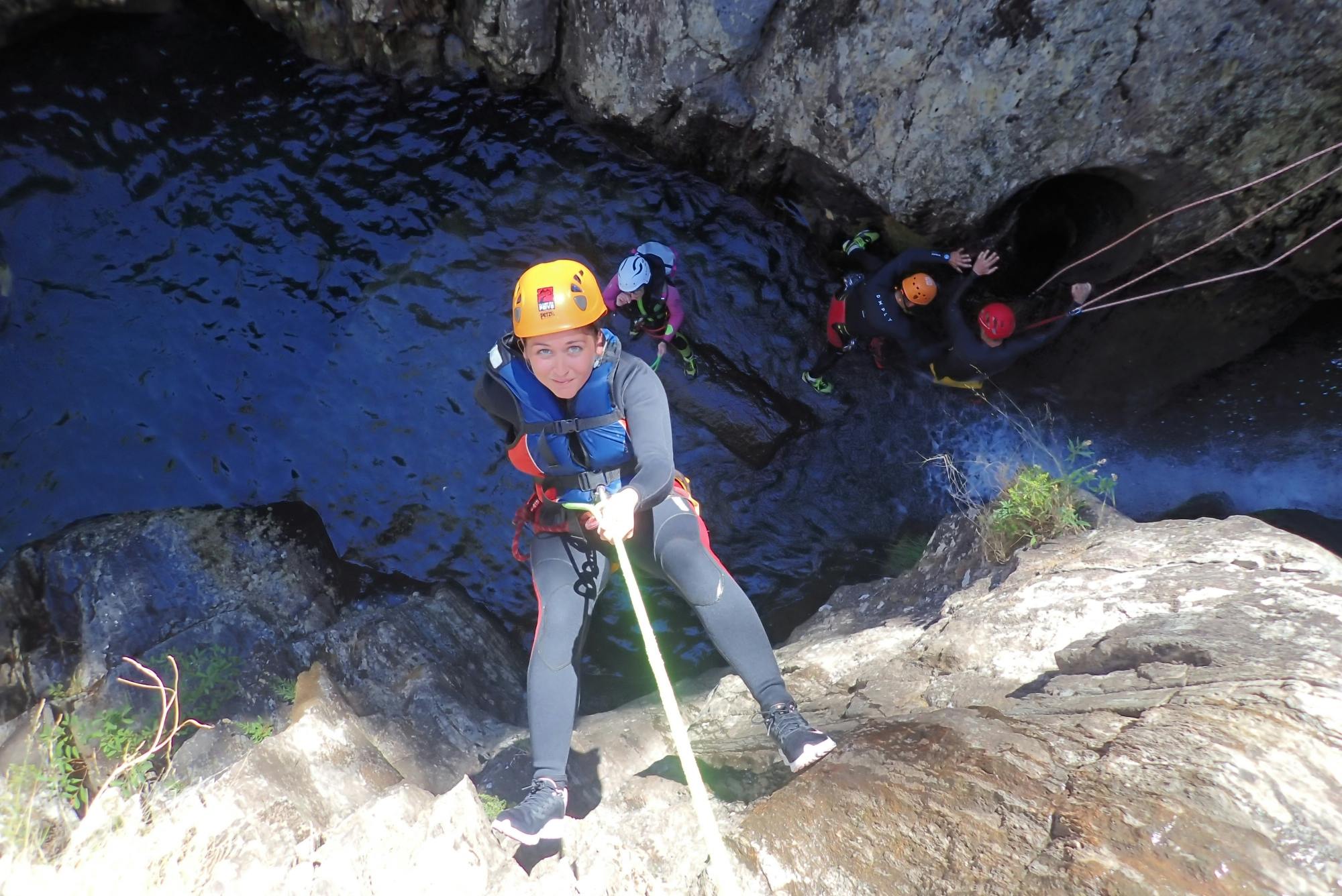
Canyoning is the guided descent of a steep river, mountain stream or narrow gorge using a combination of outdoor techniques.
A typical route may include:
Walking through flowing water.
Scrambling over wet rocks.
Swimming through natural pools.
Descending waterfalls by rope.
Sliding down smooth rock channels.
Jumping into deep pools where conditions allow.
Crossing rock faces using fixed or temporary safety ropes.
Canyoning differs from ordinary hiking because the waterway itself forms the route. Once participants enter a narrow section, leaving the canyon may not be possible until the next established exit.
This is why canyoning should be undertaken with a qualified local guide unless participants have specialist training, technical equipment and detailed knowledge of the canyon.
Arouca UNESCO Global Geopark
Arouca Geopark covers approximately 328 square kilometres of mountains, river valleys and traditional villages.
The territory is recognised for geological features including:
Giant trilobite fossils.
The unusual “birthing stones” of Castanheira.
Granite plateaus.
Waterfalls.
Mining landscapes.
Metamorphic rock formations.
The Paiva Gorge.
The geopark’s waterways are closely connected with its geology. Hard granite, fractured rock and softer schist have produced waterfalls, narrow gorges and deep pools suitable for canyoning.
Visitors may encounter alder, ash and willow near the rivers, together with kingfishers, salamanders, lizards, butterflies and dragonflies.
These are not interchangeable visitor attractions.
Differences may include:
Waterfall height.
Length of rappels.
Number of compulsory obstacles.
Water temperature.
Swimming distance.
Approach and exit walks.
Technical rope requirements.
Seasonal water flow.
Beginners should book a programme described specifically as discovery, introduction or family canyoning rather than choosing a canyon name independently.
Rio de Frades
Rio de Frades is Arouca’s best-known canyoning destination.
The stream descends through a wild valley connected with historic tungsten and tin mining. Clear water, rock walls, waterfalls and former mining galleries give the route an unusual combination of natural scenery and industrial history.
Commercial descents may include:
Rappelling beside or through waterfalls.
Swimming in clear pools.
Rock jumps.
Natural slides.
Scrambling through narrow channels.
A finish near the Vale da Cerdeira mining gallery.
Rio de Frades is divided into upper and lower canyoning sections. The route chosen depends on experience, water level and the operator’s programme.
Mining History
The surrounding region experienced intensive tungsten mining during the Second World War.
Ruined buildings, paths and galleries remain in the valley. Some old underground spaces now provide habitat for bats and should not be entered without permission and specialist guidance.
Who Is Rio de Frades For?
It is most appropriate for:
Active adults.
Teenagers meeting the operator’s age requirement.
Beginners booking a professionally adapted descent.
People comfortable with water and heights.
Groups seeking a full half-day or day adventure.
Families with very young children are normally directed to a smaller, easier stream.
Family and Beginner Canyoning
Family canyoning uses shorter and less technical waterways.
A typical beginner programme may feature:
Small waterfalls.
Simple rope descents.
Short swims.
Low natural slides.
Optional jumps.
Easy escape routes.
A guide positioned closely beside children.
Ribeira de Vessadas and smaller waterways around rural villages are among the locations associated with family experiences.
Current commercial programmes accept children from approximately five or six years old, but age alone does not determine suitability.
The child should also be able to:
Follow instructions.
Remain calm in cold water.
Walk over uneven ground.
Wear the required safety equipment correctly.
Be separated briefly from a parent while a guide manages a rope descent.
Ribeira do Fontão and Vau
Ribeira do Fontão enters the Paiva near Vau, approximately midway along the Paiva Walkways.
The stream follows a fractured valley before dropping in a waterfall close to the river. The lower section provides terrain used for canyoning and introductory activities.
Vau is also important because it is:
A rest point along the Paiva Walkways.
Close to a small suspension crossing.
A starting or finishing point for some white-water activities.
A useful location for observing the Paiva’s riverside vegetation.
Access arrangements should be organised through the operator because normal walkway admission does not authorise independent canyoning.
Aguieiras Waterfall
Aguieiras Waterfall consists of several drops along the Chieira stream, a tributary of the Paiva.
The complete formation descends approximately 140 metres through fractured granite.
The waterfall can be seen from the 516 Arouca suspension bridge and sections of the Paiva Walkways.
It is associated with technical canyoning, but it should not be approached as an unsupervised swimming waterfall. The height, exposed rock and multiple drops demand specialist knowledge and equipment.
Other Arouca Canyons
Mizarela and Castanheira
The Serra da Freita contains steep waterways around Mizarela and Castanheira. Seasonal flow strongly affects these routes.
Côto do Boi
Upper and lower sections of Côto do Boi form after significant rainfall and may be particularly associated with the wetter months.
Pena Amarela
The Pena Amarela waterways run through the Rio de Frades mining region and provide technical upper and lower sections.
Rio Pequenino
This smaller canyon offers another route within the geopark’s extensive adventure network.
Visitors should not select one of these routes solely from photographs. The guide must assess whether its water level and technical features are appropriate for the group.
Current Tour Examples
The following examples illustrate the range available in 2026. They are not the only operators or programmes, and prices should be rechecked before booking.
Programme example
Duration
Minimum age
Season
Current advertised price
Family or Discovery Canyoning
Approximately 3½ hours
6 years
May–October
From €70 per person
Adventure Canyoning
Approximately 4 hours
16 years
May–October
From €70 per person for groups above three; higher for smaller groups
Rio de Frades or group-adjusted canyoning
Approximately 6 hours
From 5 years on selected family routes
May–September
Price supplied during booking enquiry
Inclusions commonly cover:
Qualified guides.
Wetsuit.
Helmet.
Harness and ropes.
Personal-accident insurance.
Liability insurance.
Transfer from the meeting point to the canyon.
Water or a small snack.
Photographs or video.
Confirm every inclusion in writing. Porto pickup, lunch, specialist footwear and hotel transfers may cost extra.
What Happens on a Canyoning Tour?
1. Meeting and Registration
Participants meet in Arouca town, Alvarenga, the operator’s base or another confirmed location.
The guide checks:
Booking details.
Age and group composition.
Medical information.
Clothing and footwear.
Transport arrangements.
2. Transfer to the Canyon
The operator may provide a minibus or four-wheel-drive transfer. Some programmes require guests to follow the guide in their own car.
The road to the canyon can be narrow, steep and remote.
3. Equipment Fitting
Participants receive a wetsuit, helmet, harness and other required gear.
Correct fit is important. A loose helmet or oversized harness should be reported before entering the canyon.
4. Safety Briefing
The guide explains:
How to move over wet rock.
Rope signals.
Safe jumping posture.
How to use natural slides.
Where to place hands and feet.
What to do after entering a pool.
Emergency instructions.
5. Approach Walk
There is normally a walk from the vehicle to the canyon entrance.
This may involve steep tracks, forest, old mining paths or loose stone.
6. Canyon Descent
The group progresses through a sequence of pools, waterfalls and rock obstacles.
The guide installs or checks ropes and assists each participant individually where necessary.
7. Exit and Return
After leaving the water, participants walk back to a vehicle or collection point.
Dry clothes, food and drinking water are especially welcome after a long route.
Rappelling Down Waterfalls
Rappelling, also called abseiling, is the controlled descent of a rock face using a rope.
During canyoning, the rope may run beside or directly through flowing water.
The guide normally controls the safety system while the participant:
Sits back into the harness.
Keeps feet against the rock.
Moves down in small steps.
Follows instructions from above or below.
No previous climbing experience is normally required on beginner tours.
Participants uncomfortable with heights should tell the operator before booking. Some routes contain unavoidable rope descents and cannot be completed by walking around every waterfall.
Are the Jumps Compulsory?
On introductory routes, jumps are frequently optional or can be replaced with a rope descent.
However, this is not guaranteed for every canyon.
Ask the operator:
What is the highest jump?
Can every jump be bypassed?
Are any slides compulsory?
What happens if a participant refuses an obstacle?
Is there an early exit?
Never jump before the guide has checked the pool and given a clear instruction.
Natural pools change after storms. A location used safely on a previous tour may contain new debris or altered depth.
Natural Slides and Swimming
Water flowing over smooth rock can create natural slides.
The guide demonstrates the correct position, commonly involving:
Feet together.
Arms close to the body.
Head protected.
No attempt to stand before reaching calm water.
Swimming sections may be short, but a wetsuit, helmet and harness make movement different from ordinary pool swimming.
Participants should be comfortable floating and moving through deep water.
How Difficult Is Paiva Canyoning?
Difficulty ranges from low to highly technical.
Introductory Difficulty
Suitable for active beginners and families, with:
Short approach.
Small waterfalls.
Simple rappels.
Optional obstacles.
Limited swimming.
Moderate Difficulty
May involve:
Longer time in the water.
Several rappels.
Higher jumps.
Slippery scrambling.
Greater physical effort.
Advanced Difficulty
Can include:
Long or exposed rappels.
Strong water.
Few escape routes.
Sustained technical movement.
Long approaches and exits.
Cold-water endurance.
A person can be physically fit but still find canyoning difficult because of fear of heights, cold water or loss of control on slippery terrain.
Fitness and Swimming Requirements
Introductory canyoning does not require elite fitness, but participants should normally be able to:
Walk for several hours.
Climb uneven steps.
Balance on wet rock.
Swim or remain calm in deep water.
Support their body while using a rope.
Follow instructions quickly.
Adventure programmes may require considerably more endurance.
Tell the operator honestly about swimming ability. A life jacket improves buoyancy but does not remove the need to remain calm in moving water.
Minimum Age
There is no single minimum age covering every Arouca canyon.
Current examples include:
Five years for selected family canyoning.
Six years for a discovery programme.
Sixteen years for a more demanding adventure programme.
The operator may also consider:
Child height and weight.
Equipment fit.
Water temperature.
Current flow.
Group size.
Confidence around water.
Do not book a young child onto an adult adventure route merely because another company accepts the same age on a family route.
Health and Medical Considerations
Participants should disclose any condition that could affect safe movement, temperature control or emergency treatment.
Discuss the activity with the operator before booking when a participant has:
Heart or circulatory problems.
Serious breathing difficulties.
Epilepsy or unexplained loss of consciousness.
Recent surgery.
Major joint or spinal problems.
Severe fear of water or heights.
Pregnancy.
A serious allergy requiring emergency medication.
Bring essential medication in a waterproof arrangement approved by the guide.
The operator, rather than a general travel article, must make the final participation decision based on the route and current conditions.
The Canyoning Season
Most general visitor programmes operate from May until September or October.
This period normally offers:
Warmer air temperatures.
More manageable water flow.
Longer daylight.
Lower risk of severe winter floods.
Some individual streams can be used outside the main summer season when conditions are appropriate. Conversely, a route may be impossible in summer if water becomes too low.
May and June
These months may provide strong water flow and green scenery. The water remains cold.
July and August
Warm air makes immersion more comfortable, although routes and roads are busier.
September and October
Conditions can remain excellent, but shorter days and early autumn rain require closer assessment.
Winter
Heavy rainfall may create dangerous flow in major canyons. Specialist winter routes should only be attempted with guides who have selected them specifically for the conditions.
Weather and River Conditions
Canyoning is controlled by conditions throughout the drainage area, not only by the weather at the meeting point.
A canyon may be cancelled because of:
Heavy rain upstream.
Thunderstorms.
Rapidly rising water.
Cold conditions.
Fire closures.
Fallen trees or rock damage.
Unsafe road access.
Sudden water-level changes are particularly dangerous in narrow channels.
A professional operator may change the canyon, delay the start or cancel the activity. This should be treated as a safety decision rather than poor service.
Safety and Licensed Operators
Use a registered Portuguese tourist-animation company with qualified canyoning guides.
Before Booking, Confirm:
The company’s Turismo de Portugal registration.
Personal-accident insurance.
Public-liability insurance.
Guide qualifications.
Technical equipment included.
Emergency procedures.
Maximum group size.
Cancellation policy for unsafe weather.
During the Activity
Follow the guide’s instructions immediately.
Do not move ahead of the group.
Never jump without permission.
Keep the helmet fastened.
Report loose equipment.
Tell the guide when cold, tired or frightened.
Do not consume alcohol before the trip.
Independent canyoning is unsuitable for ordinary visitors. Technical rescue from a remote gorge can be difficult and slow.
Equipment Provided
A standard guided trip normally provides:
Full wetsuit.
Thermal top where necessary.
Helmet.
Canyoning harness.
Carabiners and rope equipment.
Life jacket on routes where required.
Group ropes and rescue equipment.
Some companies provide canyoning shoes, while others require participants to bring old trainers.
Ask whether wetsuits and shoes are washed and dried between uses, particularly when booking for children or during a busy summer period.
What to Bring
Swimwear: Wear it underneath the wetsuit.
Secure footwear: Old trainers with grip unless specialist shoes are supplied.
Towel: Leave it with dry clothes at the vehicle or base.
Complete change of clothes: Include underwear and warm layers.
Water: Drink before and after the canyon.
Snack: Useful after a long descent.
Sun protection: Needed during approach and exit walks.
Hair tie: Secure long hair beneath the helmet.
Medication: Inform the guide and protect it from water.
Small amount of cash: Useful for food or additional services.
Leave jewellery, watches and valuable electronics at the accommodation.
What Shoes Should You Wear?
Footwear is one of the most important personal items.
Suitable shoes should have:
A closed toe.
Secure laces.
Good wet-rock grip.
A sole that will not detach when soaked.
Enough room for neoprene socks if provided.
Avoid:
Flip-flops.
Open sandals.
Bare feet.
New fashion trainers with smooth soles.
Heavy hiking boots that retain large amounts of water.
The shoes will become completely wet and may be scratched or stained.
Photographs and Personal Belongings
Many operators include a photo report because carrying a personal phone through the canyon is risky.
Potential problems include:
Water damage.
Dropping the device into a deep pool.
Impact against rock.
Loose straps becoming caught in ropes.
Distraction during technical obstacles.
Use a personal action camera only with the guide’s permission and a secure mounting system.
Handheld selfie sticks should not be used during canyoning.
Canyoning Versus River Trekking
Feature
Canyoning
River trekking
Typical location
Steep tributary or narrow canyon
Main river or gentler river section
Ropes
Normally required
Usually limited or unnecessary
Harness
Normally worn
Often not required
Waterfall rappels
Central part of the experience
Usually absent
Swimming
Common
Common
Rock jumps
Possible
Possible
Beginner suitability
Depends strongly on route
Often easier
River trekking is a better choice for visitors who enjoy swimming and rock jumps but do not want to rappel from waterfalls.
Canyoning Versus Rafting
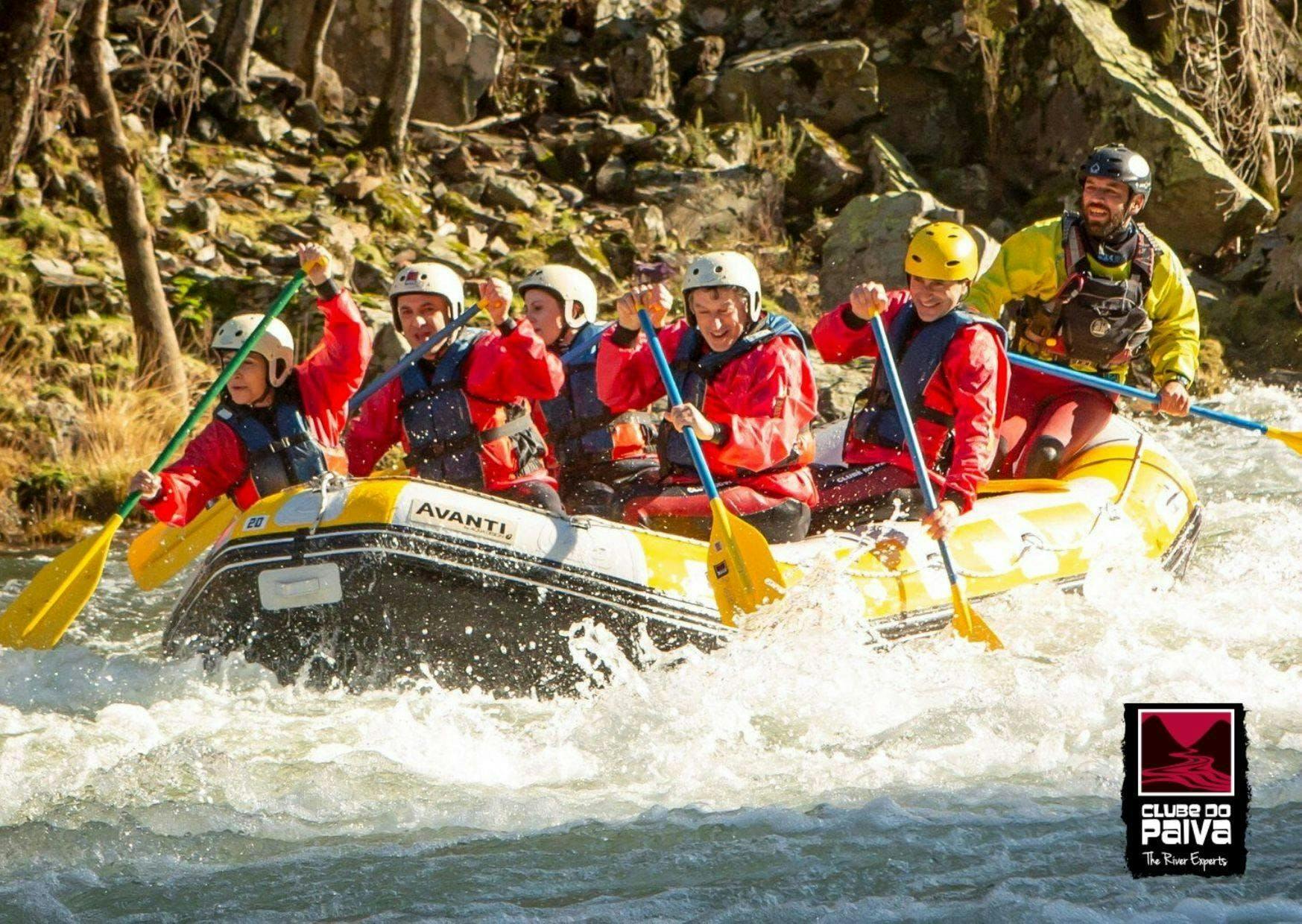
Rafting takes place in an inflatable boat on the Paiva River’s rapids.
Canyoning involves travelling on foot and by rope through a narrow tributary.
Choose Canyoning For:
Individual physical challenges.
Waterfalls and rappelling.
Close contact with rock and water.
Small-group adventure.
Choose Rafting For:
Team paddling.
Longer movement along the main river.
White-water rapids.
Participants uncomfortable with heights.
Rafting is commonly strongest during the wetter months, while mainstream canyoning programmes are concentrated in summer.
Getting to Arouca
Arouca lies inland from Porto and Aveiro in northern Portugal.
The easiest transport is:
Rental car.
Private transfer.
Operator pickup.
Organised excursion from Porto.
There is no convenient direct railway connection to the canyoning areas.
Public buses can reach Arouca town, but their timetables may not match an early activity start or a remote canyon meeting point.
Paiva Canyoning from Porto
Arouca is roughly one hour from Porto by road under favourable conditions, although the final mountain journey can make total travel longer.
A day from Porto commonly involves:
Early hotel pickup or departure.
Road transfer to Arouca.
Equipment fitting and briefing.
Three to six hours of canyoning.
Lunch or snack.
Return to Porto in late afternoon or evening.
Some operators offer Porto pickup for an additional charge or as part of a full-day package.
Confirm whether the pickup is:
From the hotel.
From a central meeting point.
Private or shared.
Included in the quoted activity price.
Meeting Points and Transfers
Meeting arrangements differ considerably.
Possible meeting locations include:
Central Arouca near the monastery.
An operator’s base in Alvarenga.
A rural village near the selected canyon.
A hotel.
A Porto pickup point.
One current operator asks participants to meet in Arouca and follow the guide in their own vehicle to the mountain start unless a transfer has been arranged.
Ask for:
A map pin.
Parking instructions.
Required arrival time.
A contact number.
What to do when delayed.
Do not rely only on the canyon name in a navigation application.
Driving and Parking
Roads within Arouca Geopark can be narrow, steep and winding.
Driving conditions may include:
Blind corners.
Single-lane village sections.
Farm vehicles.
Loose gravel near trailheads.
Limited mobile reception.
Animals on the road.
Use the operator’s meeting location rather than attempting to drive independently to Rio de Frades or another canyon entrance.
Parking is normally arranged at the base, meeting point or activity transfer location.
Do not leave luggage visible in unsupervised rural car parks.
Where to Stay
Arouca Town
Best for:
Restaurants and shops.
Meeting points.
The monastery and historic centre.
A choice of hotels and guesthouses.
Access to Serra da Freita.
Alvarenga
Best for:
Paiva Walkways and 516 Arouca.
River activities.
Rural guesthouses.
Traditional restaurants.
Espiunca
Best for the eastern entrance to the Paiva Walkways and quiet rural accommodation.
Serra da Freita
Best for hiking, waterfalls and a remote mountain atmosphere.
Porto
Best for travellers with limited time who book a transfer-inclusive canyoning day trip.
Staying in Arouca is less rushed and allows a second day for the bridge, walkways and geopark.
Paiva Walkways
The Passadiços do Paiva follow the left bank of the Paiva River between Areinho and Espiunca.
The wooden route provides views of:
Paiva Gorge.
Aguieiras Waterfall.
Vau.
River rapids.
Riparian forest.
Geological formations.
The traditional complete route is approximately eight kilometres and includes many stairs.
Storms, fires, repair work or river conditions can close individual sections. Check the live access status rather than assuming the entire route is available.
Combining the Walkways with Canyoning
A complete walkway hike and a six-hour canyoning descent are too much for most visitors on the same day.
Better combinations include:
Short morning canyoning and a brief Vau or Areinho walk.
Canyoning on day one and the complete walkway on day two.
The bridge and partial walkway before an afternoon activity only when timings are confirmed.
516 Arouca Suspension Bridge
516 Arouca crosses the Paiva Gorge near Aguieiras Waterfall.
The bridge is:
516 metres long.
Approximately 175 metres above the river at its highest point.
Fitted with a transparent metal-grid deck.
Crossed as part of a timed guided visit.
Bridge tickets are limited and are not normally sold at the bridge entrance. Advance booking is essential.
The ticket includes access to the Areinho–Vau section of the Paiva Walkways on the same day under current arrangements.
Important Rules
Minimum age is six.
Children and teenagers must be accompanied.
Suitable closed footwear is required.
Dogs are not permitted.
Visits may be cancelled because of wind or storms.
Arrive before the selected time.
The bridge can be uncomfortable for visitors with severe fear of heights because the grid floor allows views directly into the gorge.
Rio de Frades Mines
The abandoned mines around Rio de Frades add historical interest to the canyoning landscape.
Tungsten and tin were extracted in the region, with activity increasing dramatically during the Second World War.
Today visitors may see:
Ruined mining structures.
Old tracks.
Gallery entrances.
Stone remains hidden by vegetation.
Interpretive walking routes.
Never enter an abandoned gallery independently. Risks include collapse, deep water, poor air, hidden shafts and disturbance of bat colonies.
Other Attractions Near Arouca
Frecha da Mizarela
This high waterfall drops from the Serra da Freita plateau and is most impressive after rain.
Pedras Parideiras
The “birthing stones” of Castanheira are a rare geological phenomenon in which dark nodules weather out of the surrounding granite.
Giant Trilobites of Canelas
A local interpretation centre displays unusually large trilobite fossils found in the region’s slate.
Drave
Drave is an isolated slate village reached on foot. It requires a separate half-day or longer excursion.
Senhora da Mó
This hilltop viewpoint overlooks Arouca town and the surrounding mountain landscape.
Arouca Monastery
The historic monastery stands in the town centre and provides a cultural contrast with the region’s adventure activities.
Food to Try
Arouquesa Veal
Arouquesa beef is the region’s best-known speciality. Roasted veal is commonly served with potatoes and seasonal vegetables.
Posta Arouquesa
This thick grilled beef steak is a substantial meal after an outdoor activity.
Convent Sweets
Arouca’s monastery tradition produced rich sweets based on egg yolk, sugar and almonds.
Other Local Foods
Regional cheeses.
Smoked meats.
Traditional bread.
Chestnut dishes.
Honey.
Vinho Verde and Douro-region wines.
Do not drink alcohol before canyoning. Save wine or local spirits for the evening after the activity.
Suggested One-Day Canyoning Itinerary
7:30 am: Leave Porto
Drive or meet the arranged transfer.
9:00 am: Meet in Arouca
Complete registration, equipment fitting and the safety briefing.
9:45 am: Transfer to the Canyon
Travel with the guide to Rio de Frades or the route selected for the group.
10:30 am–2:30 pm: Canyoning
Descend waterfalls, swim through pools and complete the canyon exit.
3:00 pm: Change and Late Lunch
Eat Arouquesa veal or another regional meal.
4:30 pm: Short Geopark Stop
Choose Senhora da Mó, Arouca’s historic centre or a short Paiva viewpoint.
6:00 pm: Return to Porto
Allow additional time on weekends and during summer.
Suggested Two-Day Arouca Adventure Itinerary
Day One: Canyoning and Arouca
Arrive in Arouca the previous evening or early morning.
Complete a discovery or adventure canyoning tour.
Have a late lunch.
Explore Arouca town and monastery.
Stay in Arouca or Alvarenga.
Day Two: 516 Arouca and Paiva Walkways
Attend a pre-booked morning bridge visit.
Walk the available Paiva Walkways section.
Stop at Vau or Areinho.
Have lunch in Alvarenga.
Visit a geopark viewpoint before departure.
This two-day schedule is safer and more enjoyable than attempting a major canyon descent, the full walkway and the bridge in one day.
Canyoning with Children
Arouca offers genuine family canyoning, but the correct product must be selected.
Before Booking, Ask:
What is the minimum age for this exact route?
What is the coldest and deepest swimming section?
Are all jumps optional?
How high is the longest rappel?
Does the guide provide child-sized equipment?
Can a nervous child leave early?
How many children are assigned to each guide?
Prepare Children By Explaining:
The water will feel cold initially.
The helmet must remain fastened.
They may need to wait while others descend.
The guide’s instruction overrides peer pressure.
Refusing an optional jump is acceptable.
Do not surprise a child with canyoning when they believe they are attending an ordinary swimming trip.
Older Travellers
There is no universal maximum age. Physical condition is more relevant than age alone.
Older active travellers may enjoy introductory canyoning when they have:
Good balance.
Healthy knees and hips.
Confidence in water.
Enough strength to manage slippery rocks.
No uncontrolled health condition.
A long Rio de Frades route may be unsuitable for someone who comfortably walks on level ground but struggles with repeated squatting, climbing and wet-rock balance.
Discuss the precise route with the operator rather than relying on a general description such as “beginner friendly.”
Responsible Canyoning
Canyons are sensitive habitats rather than permanent adventure parks.
Use established operators and access routes.
Do not leave litter.
Avoid sunscreen immediately before entering small pools when practical.
Do not remove rocks, plants or fossils.
Do not enter bat galleries.
Keep noise low near wildlife and villages.
Use toilets before entering the canyon.
Follow fire restrictions.
Do not damage anchors or safety equipment.
Support local accommodation, restaurants and guides.
Small groups generally reduce congestion and environmental impact inside narrow canyons.
Is Paiva River Canyoning Worth It?
Paiva canyoning is highly worthwhile for active travellers who want more involvement than an ordinary sightseeing trip.
Main Advantages
Clear mountain water.
Waterfalls and natural pools.
Routes for families, beginners and experienced participants.
Professional local operators.
Unusual mining history at Rio de Frades.
Easy combination with 516 Arouca and the Paiva Walkways.
Approximately one hour from Porto.
Equipment and insurance normally included.
Possible Drawbacks
Cold water.
Slippery rock.
Fear of heights.
Weather-related cancellation.
Limited independent public transport.
Long approach or exit walks.
Routes that cannot be left easily.
Minimum age and health restrictions.
The strongest experience comes from choosing a route that matches the least-confident member of the group. A well-run introductory descent is more enjoyable than struggling through a canyon that is too technical.
Frequently Asked Questions About Paiva River Canyoning
Where is Paiva River canyoning?
It takes place around Arouca in northern Portugal, within Arouca UNESCO Global Geopark.
Is it close to Porto?
Yes. Arouca is approximately 50 kilometres from Porto, although mountain-road travel can take more than an hour.
Does canyoning take place in the main Paiva River?
Usually not. Most canyoning takes place in steep tributaries such as Rio de Frades. The main Paiva is more commonly used for rafting and river trekking.
What is the best-known canyon?
Rio de Frades is the region’s best-known canyoning location.
How many canyoning routes are there?
Arouca Geopark identifies eleven established canyoning routes with different difficulty levels.
What does canyoning involve?
It combines walking, swimming, scrambling, natural slides, rock jumps and waterfall rappelling.
Do I need previous experience?
No previous experience is usually required for discovery and beginner tours.
Do I need to know how to swim?
Most programmes expect participants to be able to swim or remain calm in deep water. Confirm the exact requirement with the operator.
How long does a tour take?
Commercial tours commonly last between 3½ and 6 hours, including briefing and transfers.
How much does canyoning cost?
Current introductory examples begin around €70 per person. Prices vary with group size, route, transfer and inclusions.
What is normally included?
Wetsuit, helmet, harness, technical equipment, guide, insurance, local transfer and photographs are commonly included.
Is transport from Porto included?
Not always. Some operators provide Porto pickup at additional cost or within a full-day package.
What is the minimum age?
Selected family tours accept children from five or six. More demanding programmes may require participants to be at least 16.
Is there a maximum age?
There is normally no simple maximum age, but the operator assesses health, mobility and fitness.
Are the jumps compulsory?
Many introductory-route jumps are optional, but not every obstacle in every canyon can be bypassed.
What is the highest jump?
It depends on the route and current water depth. Ask the operator for the specific programme.
Do I have to rappel?
Yes on most true canyoning routes. River trekking may be a better alternative when you do not want to use ropes.
Is canyoning frightening?
It can feel intimidating because of cold water, heights and slippery rock. Beginner routes are designed to introduce the techniques gradually.
Is canyoning safe?
Guided canyoning uses specialised equipment and risk management, but it remains an adventure activity. Use a licensed and insured operator.
Can I go independently?
Independent canyoning is unsuitable without specialist training, rescue knowledge, technical equipment and detailed route information.
When is the canyoning season?
Most visitor programmes operate from May until September or October.
Can canyoning be cancelled?
Yes. Heavy rain, thunderstorms, unsafe water levels, fire restrictions or damaged access can cause cancellation.
What happens if it rains?
Light rain may not stop the activity, but upstream rainfall or storms can make a narrow canyon dangerous.
Is the water cold?
Yes. Mountain streams remain cool even during summer, which is why wetsuits are provided.
What should I wear under the wetsuit?
Wear swimwear.
What shoes do I need?
Use secure closed trainers with good wet-rock grip unless canyoning shoes are supplied.
Can I wear sandals?
Open sandals and flip-flops are normally unsuitable.
Will my shoes get wet?
Yes. They will be fully submerged.
Should I bring a towel?
Yes, together with a complete change of dry clothes.
Can I carry my phone?
It is better to leave it in a secure dry location and use the operator’s included photo service.
Are photographs included?
Many current tours include photographs or video, but this should be confirmed when booking.
Can I use an action camera?
Only with the guide’s approval and a secure mount.
Is food included?
Some tours include water and a snack. Lunch may be optional or part of a larger package.
Are toilets available in the canyon?
No. Use facilities before the transfer to the route.
Can pregnant visitors participate?
Canyoning is normally unsuitable during pregnancy. Discuss this directly with the operator.
Can someone with a heart condition participate?
Medical conditions must be disclosed. The route operator should determine suitability before booking.
Can non-swimmers participate?
Some extremely gentle family programmes may use buoyancy equipment, but non-swimmers must obtain explicit approval from the operator.
Is canyoning suitable for families?
Yes, when booking a dedicated family or discovery route rather than an adult adventure descent.
Is Rio de Frades suitable for children?
Selected adapted programmes may be suitable for older children, while very young families are normally taken to a smaller stream.
What is river trekking?
River trekking involves moving along the river by walking, swimming and jumping without the extensive rope work used in canyoning.
What is rafting?
Rafting is a group descent of the Paiva River’s rapids in an inflatable boat.
Which is easier, rafting or canyoning?
It depends on the programme. Introductory rafting is often less demanding for people uncomfortable with heights, while family canyoning can be suitable for young children.
Can I combine canyoning with the Paiva Walkways?
Yes, but a long canyon and the complete walkway are usually better spread over two days.
Can I combine canyoning with 516 Arouca?
Yes, provided the bridge time and activity schedule are coordinated carefully.
Do I need to book 516 Arouca in advance?
Yes. Visits are timed, capacity is limited and tickets are not normally sold at the bridge entrance.
How high is 516 Arouca?
Its highest point is approximately 175 metres above the Paiva River.
How long is the bridge?
It is 516 metres long.
What is the minimum bridge age?
Children must be at least six years old.
Where should I stay?
Arouca is the most convenient all-round base, while Alvarenga is useful for river activities, the bridge and walkways.
Can I visit from Porto in one day?
Yes. A transfer-inclusive canyoning excursion makes this straightforward.
Is there a train to Arouca?
No convenient direct rail service reaches the canyoning area.
Can I use public buses?
Buses may reach Arouca town, but schedules and remote meeting points make a car or arranged transfer more practical.
What food should I try afterwards?
Arouquesa veal, regional cheese and Arouca’s convent sweets are popular choices.
Is Paiva canyoning suitable in winter?
Mainstream commercial programmes are usually seasonal. High flow can make winter canyons unsafe, although specialists may use selected routes.
What is the biggest booking mistake?
Booking an adventure route without checking whether every participant is comfortable with swimming, heights and rappelling.
What is the most important safety rule?
Never jump, slide or descend until the guide gives a clear instruction.
Sponsored Popular Items
Quick take: Musement.com offers a worldwide selection of tours and attractions
Paiva River rafting experience in Arouca – Outdoor Adventure Portugal Paiva River rafting experience in Arouca adds movement, scenery and a more active element to the itinerary. Check current availability, inclusions and booking details before you go.
Final Thoughts
Paiva River canyoning provides a much closer experience of Arouca’s landscape than viewing the valley from a road or footbridge.
Participants enter the mountain waterways themselves, moving through waterfalls, narrow rock channels and clear pools that cannot be seen from ordinary walking routes.
The name can be slightly misleading. The best canyoning normally occurs in tributaries such as Rio de Frades rather than in the main Paiva River. This distinction helps travellers choose between canyoning, rafting and river trekking.
Families and first-time participants should select a discovery programme with optional obstacles. Stronger and more confident travellers can choose a longer Rio de Frades descent involving sustained swimming and multiple rappels.
Stay overnight when possible and add the Paiva Walkways or 516 Arouca on a second day. Together, the canyon, river gorge, suspension bridge and mountain villages create one of northern Portugal’s most rewarding outdoor itineraries.
Sponsored Popular Items
Quick take: Musement.com offers a worldwide selection of tours and attractions
Paiva River Six-Hour Canyoning Experience from Arouca Portugal Paiva river six-hour canyoning experience from Arouca is for travellers who want movement, scenery and a more active element in their itinerary. Check current availability, inclusions and booking details before you go.
Paiva River rafting experience in Arouca – Outdoor Adventure Portugal Paiva River rafting experience in Arouca adds movement, scenery and a more active element to the itinerary. Check current availability, inclusions and booking details before you go.
The Gallerie dell’Accademia in Venice contains the world’s most important collection of Venetian painting. Its galleries trace the development of art in Venice and the Veneto from the luminous religious panels of the 14th century to the grand narrative canvases, portraits and city views of the Renaissance, Baroque and early modern periods.
The collection includes major works by Giovanni Bellini, Gentile Bellini, Giorgione, Titian, Tintoretto, Veronese, Carpaccio, Mantegna, Tiepolo, Canaletto and Guardi. Many of these paintings were originally commissioned for Venetian churches, monasteries, confraternities and public buildings, making the museum one of the best places to understand the city beyond its canals and palaces.
The museum occupies the historic Santa Maria della Carità complex in Dorsoduro, directly beside the Accademia Bridge. The buildings include a former church, monastery and Scuola Grande, with architectural work connected with Andrea Palladio.
A visit is rewarding even for travellers who do not normally spend much time in art museums. The collection contains enormous paintings showing ceremonies, processions, miracles, architecture, clothing and daily life in Renaissance Venice. These works reveal how the city represented itself during the height of its commercial and political power.
This guide explains the current 2026 ticket prices, opening arrangements, essential masterpieces, accessibility, transport, museum facilities and how to combine the Accademia with the rest of Dorsoduro.
Gallerie dell’Accademia Quick Facts
Visitor information
Details
Official name
Gallerie dell’Accademia di Venezia
Location
Campo della Carità, Dorsoduro, Venice
Main collection
Venetian painting from the 14th to early 19th centuries
Principal artists
Bellini, Giorgione, Titian, Tintoretto, Veronese, Carpaccio, Tiepolo, Canaletto and Guardi
Current 2026 adult ticket
€20 until 18 October 2026; normally €15 afterwards
Eligible EU visitors aged 18–25
€2 with identification
Visitors under 18
Free with identification
Opening days
Tuesday to Sunday
Opening time
9:00 am
Last admission
6:00 pm
Normal closing day
Monday
Recommended visit
Two to three hours
Audio guide
€6
Cloakroom
€0.50 per item; compulsory for larger bags and umbrellas
Nearest vaporetto stop
Accademia
Walking distance from Saint Mark’s Square
Approximately 15–20 minutes
Walking distance from Santa Lucia station
Approximately 20–30 minutes, depending on route and pace
Famous drawing
Leonardo’s Vitruvian Man, normally not displayed
Important: Individual rooms and paintings may close because of restoration, loans, exhibition installation or building work. Check the museum’s current unavailable-artwork notice when a specific painting is essential to your visit.
What Are the Gallerie dell’Accademia?
The Gallerie dell’Accademia are an Italian state museum devoted primarily to the artistic traditions of Venice and the Veneto.
The plural word Gallerie reflects the museum’s origins as a collection of galleries associated with Venice’s Academy of Fine Arts.
The museum should not be confused with:
The Galleria dell’Accademia in Florence, famous for Michelangelo’s David.
The Accademia di Belle Arti di Venezia, which is the modern art school.
The Accademia Bridge, which crosses the Grand Canal beside the museum.
The Venice museum contains paintings and works on paper rather than a broad collection of ancient sculpture or decorative arts.
Its great strength is concentration. Instead of trying to represent every European school, it provides an unusually complete account of how Venetian painting developed over several centuries.
Why Visit the Accademia?
The Accademia is essential for understanding Venice as more than an attractive tourist destination.
Its paintings show:
How Venice presented political ceremonies.
How religious confraternities commissioned art.
The appearance of streets, canals and public buildings.
Clothing worn by nobles, merchants, clergy and ordinary citizens.
How artists used colour, light and atmosphere.
The city’s relationships with trade, pilgrimage and the eastern Mediterranean.
The transition from medieval religious imagery to Renaissance naturalism.
The development of dramatic Baroque and Rococo painting.
Many visitors recognise places within the paintings. Carpaccio and Gentile Bellini show bridges, squares, canals, processions and architecture that can still be compared with modern Venice.
The museum is also generally calmer than the Doge’s Palace and Saint Mark’s Basilica. Even during busy periods, it is possible to spend time examining individual paintings without moving continuously in a crowd.
A Short History of the Museum
Venice’s artistic academy developed from an institution for painters and sculptors established during the 18th century.
The modern museum emerged during the political upheaval that followed the fall of the Venetian Republic in 1797.
Under Napoleonic rule, religious orders and confraternities were suppressed. Churches, monasteries, scuole and public buildings lost large numbers of artworks.
Some paintings were transported to France or Milan. Others were collected in Venice to serve as examples for the education of artists and to preserve important works that might otherwise have been dispersed.
The Santa Maria della Carità complex was designated as the new home of the Academy of Fine Arts and its picture gallery in 1807.
Architect Giannantonio Selva supervised work to adapt the historic buildings for their new purpose. The gallery opened to the public in August 1817.
During the 19th century, the collection expanded through:
Works returned from France.
Paintings transferred from suppressed churches.
Private gifts and bequests.
Government purchases.
Works originally collected for teaching.
The museum gradually separated from the Academy of Fine Arts and increasingly concentrated on Venetian painting.
This decision created the unusually coherent collection visitors see today.
The Santa Maria della Carità Complex
The museum occupies several connected historic structures:
The former Church of Santa Maria della Carità.
The monastery attached to the church.
The Scuola Grande di Santa Maria della Carità.
The earliest religious buildings on the site date from the 12th century.
The monastery and church were altered several times during the medieval and Renaissance periods. Andrea Palladio contributed to the eastern section of the monastery during the 16th century.
The Scuola Grande della Carità was Venice’s oldest major lay confraternity. Like other Venetian scuole, it combined charitable, religious and social functions.
The building is not merely a neutral container for paintings. Several rooms preserve:
Historic ceilings.
Marble floors.
Monumental staircases.
Architectural fragments.
Large walls originally suited to Venetian narrative paintings.
Look up as well as at the paintings. The scale and decoration of the rooms are part of the museum experience.
Understanding the Collection
Venetian painters developed a reputation for colour, atmospheric light and richly textured surfaces.
Artists elsewhere in Renaissance Italy often placed strong emphasis on precise drawing and the intellectual construction of form. Venetian painting became particularly celebrated for the expressive use of oil paint, colour and shifting light.
The collection allows visitors to follow this development through:
Medieval gold-ground panels.
Early experiments with perspective.
Bellini’s calm and luminous religious images.
Giorgione’s poetic and mysterious landscapes.
Titian’s colour and psychological depth.
Tintoretto’s movement and dramatic lighting.
Veronese’s architecture and ceremonial splendour.
Tiepolo’s bright theatrical compositions.
Canaletto and Guardi’s views of Venice.
The chronological organisation is useful, but visitors do not need to study every room in equal depth.
A focused visit built around ten or twelve major paintings is often more satisfying than rushing past the complete collection.
Essential Masterpieces at a Glance
Artist
Work or group
Why it matters
Giorgione
The Tempest
One of the Renaissance’s most mysterious paintings
Titian
Pietà
The artist’s powerful final work
Titian
Presentation of the Virgin at the Temple
Large narrative painting created for the Carità complex
Paolo Veronese
Feast in the House of Levi
Monumental banquet scene and masterpiece of Venetian spectacle
Tintoretto
Miracle of the Slave
Dramatic movement, foreshortening and theatrical light
Vittore Carpaccio
Stories of Saint Ursula
Narrative cycle filled with architecture and daily life
Gentile Bellini
Procession in Saint Mark’s Square
Detailed image of civic and religious Venice
Vittore Carpaccio
Miracle of the Relic of the Holy Cross at Rialto
Rare visual record of Renaissance Rialto
Giovanni Bellini
San Giobbe Altarpiece
Major example of Venetian sacred atmosphere and colour
Andrea Mantegna
Saint George
Precise, sculptural Renaissance figure painting
Canaletto
Architectural and Venetian views
Controlled perspective and detailed city observation
Francesco Guardi
Venetian scenes
More atmospheric and expressive view painting
Displays can change. Some works may be temporarily removed for conservation, research or loans.
Giorgione’s The Tempest
The Tempest is one of the museum’s most famous works and one of the most debated paintings in European art.
The scene shows:
A partially clothed woman nursing a child.
A standing young man.
A landscape divided by water.
A distant city.
A flash of lightning in a darkening sky.
No single explanation of the subject has achieved universal acceptance.
The painting has been interpreted as:
A biblical narrative.
A classical myth.
An allegory of fortune or exile.
A poetic landscape without a simple narrative.
A work concerned with human vulnerability before nature.
Its importance lies partly in this uncertainty.
Rather than presenting a clearly identifiable religious or historical event, Giorgione creates mood through colour, weather, landscape and the ambiguous relationship between the figures.
The painting is relatively small compared with the enormous canvases elsewhere in the museum. It is easy to pass without noticing how radical and unusual it is.
Titian at the Accademia
Titian was the dominant Venetian painter of much of the 16th century.
His career included religious commissions, mythological scenes and portraits of rulers across Europe.
Pietà
Titian’s Pietà was created near the end of his life and was intended for his own burial chapel.
The painting shows the dead Christ supported by the Virgin Mary and surrounded by figures expressing grief and prayer.
The brushwork is loose and emotionally intense, particularly when compared with Titian’s earlier, more polished paintings.
Titian died during the plague of 1576 before the work was completely finished. Palma il Giovane made later additions.
Presentation of the Virgin at the Temple
This vast painting was created for the Scuola Grande della Carità, the building that now forms part of the museum.
The young Virgin climbs a monumental staircase while groups of spectators occupy an elaborate architectural setting.
Because the work remains close to its original location, visitors can better understand its intended scale and relationship with the room.
Why Titian Matters
Titian transformed oil painting through:
Layered colour.
Expressive brushwork.
Complex flesh tones.
Psychological portraiture.
Dramatic use of light.
Stand back from his large paintings before moving closer. From a distance, the forms appear unified; close inspection reveals strokes and layers that can seem surprisingly free.
Veronese’s Feast in the House of Levi
Feast in the House of Levi is among the largest and most visually impressive paintings in the museum.
Veronese originally painted it for the refectory of a Dominican monastery.
The work was intended to represent the Last Supper, but church authorities questioned the presence of:
Soldiers.
Foreign figures.
Servants.
Animals.
People behaving informally.
Elaborate architectural and banquet details.
Veronese was summoned before the Venetian Inquisition and questioned about the painting.
Rather than substantially repainting it, he changed its title to a different biblical banquet: the Feast in the House of Levi.
The painting provides a fascinating example of the relationship between:
Artistic freedom.
Religious expectations.
Venetian spectacle.
Public ceremony.
Architectural imagination.
Move from one end to the other and examine the secondary figures. Much of the work’s energy occurs away from Christ at the centre.
Tintoretto’s Dramatic Painting
Tintoretto brought speed, movement and intense lighting to Venetian painting.
His figures often appear in unstable poses, dramatic diagonals and sharply foreshortened space.
Miracle of the Slave
The painting shows Saint Mark descending dramatically from above to protect a slave who is about to be tortured for venerating the saint’s relics.
Look for:
Saint Mark’s forceful descent.
The sharply foreshortened body of the slave.
Broken instruments of torture.
The crowded circle of witnesses.
Contrasts between light and shadow.
The composition feels closer to a staged action scene than a calm devotional image.
How to View Tintoretto
Stand far enough away to understand the main diagonal movement, then move closer to examine faces, gestures and areas of rapid brushwork.
Tintoretto’s paintings are not always intended to look smooth at close range. Their power emerges through movement and distance.
Carpaccio and the Saint Ursula Cycle
Vittore Carpaccio is one of the most enjoyable artists for visitors interested in storytelling and daily life.
His cycle describing the legend of Saint Ursula was painted for a Venetian confraternity.
The works contain:
Ships.
Embassies and royal courts.
Dreams and departures.
Processions.
Architecture inspired by Venice.
Detailed fabrics, furnishings and animals.
The narrative does not always proceed in the order modern viewers expect. Read the room labels or audio guide to identify each stage.
Carpaccio often uses the saint’s story as an opportunity to describe an imaginative world built from Venetian architecture and customs.
Miracle at the Rialto Bridge
Carpaccio’s painting of a miracle involving a relic of the True Cross is especially valuable as a visual document.
It shows:
The earlier wooden Rialto Bridge.
Canal traffic.
Palaces and warehouses.
Gondolas and working boats.
People observing the miracle.
The religious event occupies only part of the composition. Much of the canvas is devoted to the living city.
Giovanni and Gentile Bellini
The Bellini family played a central role in the development of Renaissance painting in Venice.
Giovanni Bellini
Giovanni Bellini’s works are known for:
Luminous colour.
Calm landscapes.
Carefully modelled figures.
Quiet devotional atmosphere.
The integration of architecture and light.
The San Giobbe Altarpiece creates the illusion that the painted church interior extends beyond the real space in which the viewer stands.
Bellini’s paintings are particularly rewarding after seeing earlier gold-ground panels. The increasing naturalism and atmospheric light become immediately apparent.
Gentile Bellini
Gentile specialised in large ceremonial and narrative paintings.
His Procession in Saint Mark’s Square shows a major public religious event with:
The façade of Saint Mark’s Basilica.
Processional banners.
Members of a confraternity.
Officials and spectators.
Detailed architectural information.
The painting is both a religious image and a statement about Venice’s ordered civic identity.
Mantegna and Art Beyond Venice
Andrea Mantegna was associated more closely with Padua and Mantua than Venice, but his work had a profound influence on northern Italian art.
His Saint George presents the saint as a sculptural figure standing within a carefully constructed stone frame.
Typical Mantegna features include:
Precise outlines.
Interest in classical architecture.
Stone-like figures.
Detailed surfaces.
Controlled perspective.
The painting provides a useful contrast with the softer colour and atmosphere of Bellini and Giorgione.
Canaletto, Guardi and Venetian Views
By the 18th century, visitors to Venice wanted painted views to take home as records of the city.
Canaletto
Canaletto’s views are known for:
Clear perspective.
Detailed architecture.
Bright skies.
Carefully organised boats and figures.
An apparently precise description of place.
His scenes are not simple photographic records. Buildings, viewpoints and spatial relationships could be adjusted to create more effective compositions.
Francesco Guardi
Guardi’s Venice is generally more atmospheric and unstable.
His brushwork is freer, and his skies, water and architecture can seem to dissolve into light and movement.
Comparing Canaletto and Guardi provides an excellent final stage in a chronological museum visit.
Is the Vitruvian Man on Display?
Leonardo da Vinci’s Vitruvian Man belongs to the Gallerie dell’Accademia, but it is not part of the normal permanent display.
The drawing is extremely sensitive to light.
Repeated or prolonged exhibition could cause:
Fading of ink.
Changes to the paper.
Damage from light exposure.
Accelerated ageing.
For conservation reasons, it is stored under controlled conditions and shown only during selected exhibitions.
Do not purchase a normal museum ticket expecting to see it.
When a special exhibition includes the drawing, the museum normally announces this clearly because its appearance is a major event.
The 2026 Marina Abramović Exhibition
From 6 May to 18 October 2026, the museum is presenting Transforming Energy by Marina Abramović.
The exhibition accompanies the 61st Venice Art Biennale and is significant because Abramović is the first living female artist to receive a major exhibition at the Gallerie dell’Accademia.
The project extends through temporary spaces and sections of the permanent galleries, placing contemporary work in conversation with historic Venetian art.
Visitors should be aware that:
The exhibition is included in the main museum ticket.
The adult ticket is temporarily increased to €20.
The exhibition may change the atmosphere and circulation of some rooms.
Performance-related areas may have capacity limits.
Some content may require patience or participation.
The permanent collection remains a major part of the visit.
Travellers interested only in traditional Venetian painting should still allow enough time for the permanent rooms.
Current 2026 Ticket Prices
Ticket
6 May–18 October 2026
After 18 October 2026
Standard adult
€20
€15
Eligible EU visitor aged 18–25
€2
€2
Visitor under 18
Free
Free
Arteritivo, eligible visitors aged 26–35 on Friday evening
€15
€10
Eligible group ticket for 10–25 adults
€17 per person
€12 per person
Dorsoduro Museum Mile concession
€17
€12
Identification is required for reduced or free age-based admission.
Free admission may also apply to eligible visitors including:
People with qualifying disabilities.
One accompanying person where applicable.
ICOM members.
Licensed guides working with a group.
Eligible teachers and university students in specified fields.
Italian Ministry of Culture personnel.
Check current eligibility before arrival rather than assuming every international student card qualifies.
Current Opening Hours
The museum normally opens:
Monday: Closed.
Tuesday–Sunday: 9:00 am–7:00 pm.
Last entry and ticket sales: 6:00 pm.
Closing procedures: Begin around 6:30 pm.
Some parts of the museum website display a closing time of 7:15 pm. Visitors should regard 6:00 pm as the essential deadline and verify the final closing time when planning a late visit.
Monday closure can be changed around important public holidays. In 2026, alternative closure dates have been scheduled when the museum opens on selected Mondays.
Remaining unusual closure arrangements in late 2026 include dates in November and December. Check the official calendar when visiting around a national holiday.
Free-Entry Days
The Gallerie dell’Accademia participates in Italy’s Domenica al Museo programme.
General admission is normally free on the first Sunday of each month.
Additional national free-entry dates may be announced during the year.
What to Expect on a Free Sunday
No normal advance reservation.
First-come, first-served admission.
Longer queues.
Busy galleries.
Possible temporary restrictions when rooms reach capacity.
A free day is financially attractive but is not necessarily the best time for a quiet or detailed visit.
Do You Need to Book?
Reservation is usually optional for ordinary individual admission, but online booking is useful during:
The Venice Biennale.
Easter and summer holidays.
Weekends.
Major temporary exhibitions.
Periods of exceptionally high visitor numbers.
TicketOne is the museum’s authorised online ticket seller.
Avoid paying inflated prices to websites that resemble the official museum site but add unnecessary packages or large booking charges.
Check exactly what is included when purchasing a guided tour. Some third-party products include only a guide and require the museum ticket to be purchased separately.
How Long Should You Spend?
Time available
Realistic visit
45–60 minutes
Eight to ten major masterpieces
90 minutes
Collection highlights with limited room detail
2 hours
Comfortable first visit
3 hours
Detailed permanent collection and temporary exhibition
Half day
Complete museum visit with breaks and close study
Two to three hours is ideal for most visitors.
Art specialists can easily spend half a day, particularly when a major temporary exhibition is included.
The Best Museum Route
The normal route begins on the first floor before continuing to ground-floor galleries.
A useful sequence is:
Begin with medieval Venetian painting.
Follow the development of perspective and Renaissance space.
Spend time with Giovanni Bellini.
Continue to Giorgione and Titian.
Examine the large Carpaccio and Gentile Bellini narratives.
See Tintoretto and Veronese.
Continue into later Venetian painting.
Finish with Canaletto, Guardi and early modern works.
Renovation and temporary exhibitions can alter the route.
Some rooms are currently affected by ongoing building work, and accessible circulation may require assistance from staff.
A One-Hour Highlights Route
When time is limited, prioritise:
Giovanni Bellini’s major altarpiece.
Giorgione’s The Tempest.
Titian’s Pietà.
Titian’s Presentation of the Virgin.
Tintoretto’s Miracle of the Slave.
Veronese’s Feast in the House of Levi.
Carpaccio’s Saint Ursula paintings.
Gentile Bellini’s Saint Mark’s Square procession.
Carpaccio’s Rialto miracle scene.
One Canaletto or Guardi view.
Ask staff at the entrance where these works are currently displayed because room arrangements can change.
A Detailed Three-Hour Visit
First Hour: Early Venice
Focus on:
Gold-ground panels.
Early altarpieces.
Changes in spatial construction.
Giovanni Bellini.
Mantegna.
Second Hour: The High Renaissance
Prioritise:
Giorgione.
Titian.
Carpaccio.
Gentile Bellini.
Venetian ceremonial painting.
Third Hour: Drama and the City
Continue with:
Tintoretto.
Veronese.
Tiepolo.
Canaletto.
Guardi.
The current temporary exhibition.
Take one short break rather than attempting the visit continuously. Visual fatigue can make the final rooms less meaningful.
Audio Guides and Guided Tours
The permanent-collection audio guide currently costs €6.
It is available in:
Italian.
English.
French.
German.
Japanese.
Spanish.
The standard audio guide covers the permanent collection but may not include the current temporary exhibition.
Is the Audio Guide Worth It?
It is useful for visitors who:
Have limited knowledge of Venetian art.
Prefer an independent visit.
Want explanations of large narrative paintings.
Need help following the chronological development.
A private or small-group guide is particularly valuable for understanding the relationships between paintings and their original churches or confraternities.
Cloakroom and Bag Rules
The museum operates a luggage deposit currently costing €0.50 per item.
Deposit is compulsory for items larger than approximately 20 × 30 × 15 centimetres and for objects considered capable of damaging artworks or obstructing visitors.
Items that may need to be deposited include:
Large handbags.
Backpacks.
Umbrellas.
Bags with protruding metal or plastic elements.
Bulky shopping bags.
Other items identified by security staff.
Do not arrive with a suitcase expecting unlimited storage capacity.
During busy periods, use luggage storage near the railway station or accommodation before travelling to the museum.
Photography Rules
Personal photography may be permitted in many areas, subject to room signage and staff instructions.
Visitors should expect restrictions on:
Flash.
Tripods.
Selfie sticks.
Large photographic equipment.
Professional filming.
Temporary exhibitions.
Works on loan.
Commercial photography, filming and formal image reproduction require permission.
Do not block doorways or stand too close to paintings while composing photographs.
Accessibility
A barrier-free entrance is located on the right-hand side of the museum in Calle della Carità.
Visitors can ring the bell or request assistance at the main entrance.
Available Facilities
Lift access to the first floor.
Lifting platforms between selected halls.
Accessible ground-floor toilets.
Staff assistance with the most suitable route.
Current Limitations
Renovation work and equipment outages currently interrupt parts of the accessible route.
Some first-floor rooms do not have functioning platforms between level changes, and several rooms remain closed during the continuing museum-expansion project.
Visitors requiring step-free access should speak with staff on arrival rather than following the standard route without assistance.
Free Admission
Eligible visitors with disabilities and one accompanying person may receive free admission under Italian state-museum rules.
Carry suitable documentation.
Visiting with Children
The Accademia can work well for children when the visit is focused and relatively short.
Paintings Children May Enjoy
Saint George and the dragon.
Carpaccio’s ships and processions.
The old Rialto Bridge.
Animals and servants in Veronese’s banquet.
Dramatic miracles by Tintoretto.
Venetian boats and canals.
Family Strategy
Choose six to eight paintings.
Ask children to find animals, boats or unusual clothing.
Take a break in Campo della Carità afterwards.
Avoid combining the museum immediately with several other major collections.
Use a compact pushchair because lifts and routes can change.
Children under 18 enter free but should carry identification when age is not obvious.
Toilets, Bookshop and Facilities
Toilets
Toilets are situated on the ground floor and include an accessible facility.
Bookshop
The bookshop sells:
Museum guides.
Art monographs.
Books about Venetian painting.
Exhibition catalogues.
Postcards and reproductions.
Educational products.
It normally follows the museum’s opening days and general hours.
Food and Drink
Do not expect a large museum café as part of the standard visit.
Dorsoduro contains numerous cafés, bakeries and bacari within a short walk.
Food and drink should not be consumed in the exhibition rooms.
Getting to the Accademia
The museum is located at:
Campo della Carità, Dorsoduro 1050, Venice.
It stands:
Beside the southern end of the Accademia Bridge.
Across the canal from the Accademia vaporetto stop.
Within walking distance of the Peggy Guggenheim Collection.
Approximately 15–20 minutes from Saint Mark’s Square.
There is no road access to the museum for ordinary private cars.
Walking from the Station and Piazzale Roma
The museum’s official information describes it as approximately a 20-minute walk from Venezia Santa Lucia station or Piazzale Roma.
Many first-time visitors should allow 25–35 minutes because:
Navigation through Venice is slower than map distance suggests.
Bridges contain steps.
Busy lanes cause delays.
It is easy to take a wrong turn.
Luggage reduces walking speed.
Follow signs towards Accademia or Dorsoduro rather than attempting to memorise every lane.
Arriving by Vaporetto
The nearest waterbus stop is Accademia.
Lines 1 and 2 travel along the Grand Canal and stop close to the museum, subject to the current operating pattern.
From Santa Lucia Station or Piazzale Roma
Take a Line 1 or Line 2 vaporetto travelling towards the Lido or Saint Mark’s area and leave at Accademia.
From Saint Mark’s Square
Take Line 1 or 2 in the direction of Piazzale Roma and leave at Accademia.
Current General Transport Prices
Single 75-minute ACTV ticket: approximately €9.50.
One-day transport pass: €25.
Two-day transport pass: €35.
Three-day transport pass: €45.
Seven-day transport pass: €65.
A transport pass can be better value when using several vaporetti during the same day.
Validate or activate the ticket correctly before boarding.
Accademia Bridge
The Ponte dell’Accademia is one of only four bridges crossing the Grand Canal.
Its wooden structure provides one of Venice’s classic views towards Santa Maria della Salute.
Best Time for the View
Early morning for fewer people.
Late afternoon for warm light.
Blue hour for illuminated palaces and boats.
The bridge has steps and can be crowded.
Stop close to the side rather than blocking people crossing between Dorsoduro and San Marco.
Exploring Dorsoduro
Dorsoduro is one of the most rewarding districts for a slower Venice itinerary.
Its attractions include:
The Gallerie dell’Accademia.
Peggy Guggenheim Collection.
Punta della Dogana.
Basilica of Santa Maria della Salute.
Ca’ Rezzonico.
Scuola Grande dei Carmini.
Church of San Sebastiano.
Zattere waterfront.
Squero di San Trovaso boatyard.
Campo Santa Margherita.
The district combines major art collections with university life, residential streets, canalside walks and traditional eating places.
Dorsoduro Museum Mile
The Dorsoduro Museum Mile links four major cultural institutions:
Gallerie dell’Accademia.
Peggy Guggenheim Collection.
Palazzo Grassi–Punta della Dogana.
Galleria di Palazzo Cini.
A visitor holding a paid ticket or qualifying membership from one participating institution may purchase discounted admission at the other partners for a limited period.
The Accademia’s current Dorsoduro Museum Mile ticket costs:
€17 during the 2026 Abramović exhibition.
€12 after 18 October 2026.
This is a concessionary admission arrangement rather than one ticket automatically covering every museum.
Keep the original paid ticket because proof is required.
Attractions Near the Accademia
Peggy Guggenheim Collection
This museum presents major European and American modern art in Peggy Guggenheim’s former Grand Canal home.
It provides an excellent contrast with the Accademia’s historic collection.
Santa Maria della Salute
The monumental domed church stands near the entrance to the Grand Canal.
Its sacristy contains important paintings, although separate opening and admission arrangements may apply.
Punta della Dogana
The former customs house at the end of Dorsoduro is now a contemporary-art venue.
The surrounding point provides broad views across the Grand Canal and Saint Mark’s Basin.
Squero di San Trovaso
This historic boatyard repairs and maintains gondolas and other traditional vessels.
It is viewed from the opposite canal bank rather than entered as a normal public attraction.
Zattere
The long southern waterfront is ideal for:
Walking.
Lagoon views.
Watching boats.
Eating gelato.
Taking a break after the museum.
Ca’ Rezzonico
Ca’ Rezzonico is devoted to 18th-century Venice and contains paintings, furniture and decorated rooms.
It works particularly well after seeing Tiepolo, Canaletto and Guardi at the Accademia.
Where to Eat Nearby
Dorsoduro has numerous restaurants, cafés and small wine bars.
Quick Options
Look for a bacaro serving:
Cicchetti.
Small sandwiches.
Polenta with seafood.
Cheese and cured meat.
Wine by the glass.
Useful Areas
Campo Santa Margherita for casual food and cafés.
Zattere for waterfront dining.
San Trovaso for neighbourhood restaurants.
San Barnaba for bars and bakeries.
Visitor Advice
Check whether a cover charge applies.
Look at displayed prices before sitting down.
Avoid relying only on restaurants immediately beside the busiest landmarks.
Reserve ahead for an evening meal during Biennale and summer weekends.
The Best Time to Visit
At Opening Time
Arriving at 9:00 am generally provides:
Quieter galleries.
Better access to famous paintings.
Lower group-tour numbers.
More time for the rest of Dorsoduro.
Late Afternoon
Late afternoon can also be quiet, but the final entry at 6:00 pm leaves limited time.
Do not arrive at 5:45 pm expecting a complete visit.
Tuesday to Thursday
Midweek mornings are often calmer than weekends, first Sundays and public holidays.
During the Biennale
Venice’s international art and architecture exhibitions increase cultural tourism across the city.
The museum can be busier during:
Biennale opening weeks.
Major preview periods.
Festival weekends.
Special contemporary exhibitions.
Venice Access Fee in 2026
Visitors making a day trip into historic Venice may need to comply with the city’s 2026 Access Fee on selected dates.
The 2026 scheme applies on specified days from 3 April through 26 July between 8:30 am and 4:00 pm.
The fee is:
€5 when paid by the fourth day before entry.
€10 when paid during the final three days before entry or on the day.
Visitors staying overnight within the Municipality of Venice are generally exempt from payment but may need to obtain or carry proof of exemption.
The museum ticket does not include the Venice Access Fee.
Check the official calendar because the fee applies only on selected dates.
Suggested Half-Day Accademia Itinerary
9:00 am: Enter the Gallerie
Begin with the early Venetian rooms before tour groups arrive.
9:30 am: Bellini and Giorgione
Spend time with Bellini’s altarpiece and Giorgione’s The Tempest.
10:15 am: Titian
See Presentation of the Virgin and Pietà.
10:45 am: Carpaccio and Gentile Bellini
Study the Saint Ursula cycle and paintings of Renaissance Venice.
11:30 am: Tintoretto and Veronese
Finish the central Renaissance section with the museum’s largest and most dramatic canvases.
12:15 pm: Later Painting or Temporary Exhibition
Choose Canaletto and Guardi or spend additional time with the Marina Abramović exhibition.
1:00 pm: Lunch in Dorsoduro
Walk towards San Trovaso, Campo Santa Margherita or Zattere.
Suggested Full-Day Dorsoduro Itinerary
9:00 am: Gallerie dell’Accademia
Allow two and a half hours.
11:30 am: Accademia Bridge
Stop briefly for the Grand Canal view.
12:00 pm: Peggy Guggenheim Collection
Explore 20th-century art for approximately 90 minutes.
1:45 pm: Lunch
Eat around San Vio or San Trovaso.
3:00 pm: Santa Maria della Salute
Visit the church and continue towards Punta della Dogana.
4:00 pm: Zattere
Walk west along the Giudecca Canal waterfront.
5:00 pm: Squero di San Trovaso
See the gondola workshop from the opposite bank.
6:00 pm: Campo Santa Margherita
Finish with cicchetti, an aperitivo or dinner.
Is the Accademia Worth Visiting?
The Gallerie dell’Accademia are highly worthwhile for anyone interested in Venice, even when they are not a specialist in Renaissance art.
Main Advantages
The world’s leading collection of Venetian painting.
Works by almost every major Venetian master.
Large paintings filled with details of historic Venice.
A beautiful historic building.
A convenient Dorsoduro location.
Generally calmer than Saint Mark’s major attractions.
Excellent combination with the Peggy Guggenheim Collection.
Free admission for visitors under 18.
Possible Drawbacks
Temporary room closures.
Limited refreshment facilities.
Long visits can cause visual fatigue.
Accessibility routes may be interrupted.
The Vitruvian Man is normally unavailable.
The 2026 exhibition has temporarily increased the ticket price.
Labels may provide less detail than some visitors expect.
The museum is most rewarding when visitors choose a small number of paintings and look carefully rather than attempting to complete every room quickly.
Frequently Asked Questions About the Gallerie dell’Accademia
Where are the Gallerie dell’Accademia?
They are in Campo della Carità in Venice’s Dorsoduro district, beside the Accademia Bridge.
Is this the museum with Michelangelo’s David?
No. David is in the Galleria dell’Accademia in Florence. The Venice museum specialises in Venetian painting.
What is the museum famous for?
It is famous for paintings by Bellini, Giorgione, Titian, Tintoretto, Veronese and Carpaccio.
How much is admission in 2026?
General admission is €20 from 6 May to 18 October 2026 because it includes the Marina Abramović exhibition. It normally returns to €15 afterwards.
Is the temporary exhibition included?
Yes. The main ticket covers both the permanent collection and current temporary exhibition.
How much is the reduced ticket?
Eligible EU citizens aged 18–25 pay €2 with identification.
Are children free?
Visitors under 18 enter free with identification.
Are people with disabilities admitted free?
Eligible visitors with disabilities and one accompanying person may receive free admission under current state-museum rules.
What are the opening hours?
The museum normally opens Tuesday to Sunday from 9:00 am to 7:00 pm.
What time is last entry?
Last admission and ticket sales are at 6:00 pm.
Is the museum open on Monday?
It is normally closed on Monday, although holiday schedules can produce exceptions and alternative closing days.
How long should I spend there?
Allow two to three hours for a comfortable first visit.
Can I visit in one hour?
Yes, by concentrating on approximately ten major masterpieces.
Should I book in advance?
Booking is optional for many ordinary visits but advisable during Biennale periods, summer weekends and major exhibitions.
Where should I buy tickets?
Use the authorised TicketOne service or purchase at the museum ticket office.
Is the Vitruvian Man displayed?
No, not normally. It is shown only occasionally because light exposure can damage the drawing.
Why is the Vitruvian Man not permanently displayed?
Paper and ink are sensitive to light, temperature and humidity. Limited display protects the drawing from deterioration.
What is the most famous painting?
Giorgione’s The Tempest is probably the best-known individual painting.
What is the largest painting?
Veronese’s Feast in the House of Levi is among the museum’s largest and most monumental canvases.
What should I not miss?
Do not miss The Tempest, Titian’s Pietà, the Carpaccio cycles, Tintoretto’s Miracle of the Slave and Veronese’s banquet scene.
Are all the masterpieces always displayed?
No. Paintings can be removed temporarily for restoration, loans or gallery work.
Is there an audio guide?
Yes. The permanent-collection audio guide currently costs €6.
Which languages are available?
Italian, English, French, German, Japanese and Spanish are currently available.
Does the audio guide include temporary exhibitions?
The standard audio guide covers the permanent collection and may not include current exhibitions.
Are guided tours available?
Yes. The museum and private licensed guides offer scheduled or bookable tours.
Is there a cloakroom?
Yes. It currently costs €0.50 per item.
Do I have to leave my backpack?
Large backpacks and items exceeding the published size limit must be deposited.
Can I bring a suitcase?
A suitcase is impractical and storage capacity is limited. Use external luggage storage first.
Can I take photographs?
Personal photography may be allowed where signs permit, but flash, tripods, filming equipment and temporary exhibition photography may be restricted.
Is the museum wheelchair accessible?
It is partly accessible through a separate barrier-free entrance, lifts and platforms, but current renovation and equipment outages interrupt some routes.
Where is the accessible entrance?
It is on the right-hand side of the museum in Calle della Carità.
Are accessible toilets available?
Yes, on the ground floor.
Can I use a pushchair?
Yes, but a compact pushchair is easier because routes, lifts and level changes can be complicated.
Is the museum suitable for children?
Yes, particularly when the visit focuses on narrative paintings containing ships, animals, ceremonies and city views.
Is there a café?
Do not rely on a full museum café. Numerous cafés and bacari are available nearby in Dorsoduro.
Is there a bookshop?
Yes. It sells museum guides, catalogues and books about Venetian art.
What is the nearest vaporetto stop?
The nearest stop is Accademia.
Which vaporetto lines stop there?
Lines 1 and 2 normally serve the Accademia stop, subject to current schedules.
How far is the museum from Saint Mark’s Square?
It is approximately a 15- to 20-minute walk.
How far is it from Santa Lucia station?
The official estimate is around 20 minutes, but first-time visitors should often allow 25–35 minutes.
Is the Accademia Bridge beside the museum?
Yes. The museum stands beside the southern end of the bridge.
Is crossing the bridge free?
Yes. It is a public pedestrian bridge.
What view can I see from the bridge?
The classic view looks along the Grand Canal towards the dome of Santa Maria della Salute.
Can I combine the Accademia and Peggy Guggenheim Collection?
Yes. They are approximately a ten-minute walk apart and make an excellent historic-and-modern-art combination.
What is the Dorsoduro Museum Mile?
It is a partnership connecting the Accademia, Peggy Guggenheim Collection, Palazzo Grassi–Punta della Dogana and Palazzo Cini.
Is the Dorsoduro Museum Mile one combined ticket?
No. A paid ticket from one participating museum provides eligibility for discounted admission at the others under current conditions.
Is the museum free on the first Sunday?
Yes, under the current Domenica al Museo programme.
Do I need to reserve a free Sunday?
Normal reservations are not used. Admission is first come, first served.
Are free Sundays crowded?
They can be significantly busier than ordinary mornings.
What is Arteritivo?
It is a discounted Friday-evening ticket for eligible visitors aged 26–35.
How much is Arteritivo in 2026?
It costs €15 during the Abramović exhibition and normally €10 afterwards.
Does the museum have air conditioning?
Environmental controls protect the art, but temperatures can vary between historic rooms. Do not assume every space will feel strongly air-conditioned.
What should I wear?
Wear comfortable shoes and appropriate clothing for a cultural institution. Bring a light layer because indoor temperatures may differ from the streets.
Is it better to visit in the morning?
Yes. Opening time generally provides quieter rooms and more time for Dorsoduro afterwards.
Can I visit late in the day?
Yes, but admission ends at 6:00 pm and closing procedures begin soon afterwards.
Is the Accademia included in the standard Venice civic museum pass?
Do not assume it is included. The Accademia is a national state museum rather than one of Venice’s municipal museums.
Do I have to pay the Venice Access Fee as well?
Day visitors may need to pay or register on selected 2026 dates. The museum ticket does not include the city Access Fee.
Are overnight visitors exempt from the Venice Access Fee?
They are generally exempt from payment when staying within the Municipality of Venice, but may need proof or an exemption record.
What is the best nearby lunch area?
San Trovaso, Campo Santa Margherita and the Zattere all provide good options.
What is the biggest visitor mistake?
Expecting the Vitruvian Man to be displayed or rushing through the large narrative paintings without examining their smaller details.
Final Thoughts
The Gallerie dell’Accademia provide the clearest introduction to Venice’s artistic identity.
The collection shows how Venetian painters transformed religious stories, civic ceremonies and familiar streets into images filled with colour, atmosphere and spectacle.
Giorgione’s mysterious landscape, Titian’s final Pietà, Tintoretto’s explosive miracles, Veronese’s monumental banquet and Carpaccio’s detailed narratives each reveal a different side of Venetian painting.
Allow at least two hours and arrive near opening time. Check whether any essential painting is temporarily unavailable, and do not expect Leonardo’s Vitruvian Man unless a special exhibition explicitly includes it.
After the visit, cross the Accademia Bridge or continue through Dorsoduro towards the Peggy Guggenheim Collection, Santa Maria della Salute and the Zattere. The paintings inside the museum become even more meaningful when followed by a walk through the city that inspired them.
Lovćen National Park rises directly behind Montenegro’s Adriatic coast, creating one of the country’s most dramatic transitions between sea and mountain.
From the lower slopes above Kotor, narrow roads climb through bare limestone, forest and traditional villages to high viewpoints overlooking the Bay of Kotor, the Adriatic coast and Montenegro’s rugged interior. At the centre of the park is Jezerski Vrh, where the monumental mausoleum of Petar II Petrović-Njegoš stands at approximately 1,657 metres above sea level.
Sponsored Popular Items
Quick take: Musement.com offers a worldwide selection of tours and attractions
Lovćen National Park & Budva Full-Day Private Tour Montenegro Lovćen national park and Budva city full-day private tour places landscapes, habitats or wildlife at the centre of the experience. Check current availability, inclusions and booking details before you go.
Lovćen is much more than a single viewpoint. Visitors can walk through beech forest at Ivanova Korita, explore traditional food culture in Njeguši, drive the historic Kotor Serpentine, cycle mountain roads, follow marked hiking trails or combine the park with Cetinje, Montenegro’s former royal capital.
The park is close to Kotor and Budva on a map, but mountain roads, weather and seasonal traffic can make travel slow. A successful visit requires realistic timing, suitable footwear and an understanding that the national-park ticket, mausoleum ticket and Kotor–Lovćen cable-car ticket are separate charges.
This guide explains what to see, how to reach the park, which road to choose, how demanding the mausoleum stairs are and how to plan a practical day trip from Kotor, Budva or Cetinje.
Lovćen National Park Quick Facts
Visitor information
Details
Country
Montenegro
Location
Between Kotor, Cetinje and the Adriatic coast
National-park status
Protected since 1952
Area
Approximately 6,220 hectares
Elevation range
Approximately 939–1,749 metres
Highest peak
Štirovnik, 1,749 metres
Mausoleum peak
Jezerski Vrh, approximately 1,657 metres
Main attraction
Njegoš Mausoleum
Steps to mausoleum
461
Current park entrance
€3 per person per day
Current mausoleum adult ticket
€8, currently combined with Njegoš’s birthplace
Student mausoleum ticket
€4 with appropriate identification
Mausoleum season
Normally 15 April–15 November
Main visitor area
Ivanova Korita
Nearest cultural centre
Cetinje
Best general season
May to October
Recommended visit
One full day
Important: The national-park entrance, mausoleum entrance and Kotor–Lovćen cable car are separate charges. The cable car does not deliver passengers directly to the mausoleum.
What Is Lovćen National Park?
Lovćen is a coastal mountain massif forming part of the southern Dinaric Alps.
Its position between the Adriatic Sea and Montenegro’s interior produces an unusual combination of:
Karst limestone peaks.
Deep rock depressions.
Beech and pine forest.
High meadows.
Traditional stone settlements.
Views towards the Bay of Kotor.
Mountain weather influenced by the nearby Mediterranean.
The park’s two most prominent summits are Štirovnik and Jezerski Vrh.
Štirovnik is the highest point at 1,749 metres, but its summit is associated with communications infrastructure and is not the normal tourist destination.
Jezerski Vrh is slightly lower but far more important to visitors because it contains the Njegoš Mausoleum and panoramic viewing platform.
Why Is Lovćen Important to Montenegro?
Lovćen is one of Montenegro’s principal national symbols.
The country’s name, Crna Gora or “Black Mountain,” is traditionally associated with the appearance of forested mountains such as Lovćen when viewed from the coast.
The mountain has played several roles in Montenegrin history:
A natural defensive barrier.
A refuge during periods of conflict.
A route between coastal settlements and Cetinje.
A landscape connected with the Petrović-Njegoš dynasty.
A source of national poetry, folklore and identity.
The burial place of Petar II Petrović-Njegoš.
For many Montenegrins, visiting the mausoleum is not simply a scenic excursion. It is a journey to a monument associated with national history, language, literature and statehood.
Landscape, Geology and Wildlife
Lovćen’s pale limestone has been shaped by rain, frost and underground water.
Typical karst features include:
Sinkholes.
Rock fissures.
Dry valleys.
Uneven limestone pavements.
Small caves and underground drainage.
The lower and more sheltered parts of the park contain forest, while the higher slopes become increasingly rocky and exposed.
Plants
Depending on altitude and location, visitors may see:
Beech forest.
Black pine.
Mountain grasslands.
Mediterranean shrubs on warmer slopes.
Wildflowers during spring and early summer.
Plants adapted to exposed limestone.
Animals
The wider mountain environment supports:
Foxes.
Wild boar.
Wolves.
Brown bears in the broader region.
Small mammals.
Birds of prey.
Woodland birds.
Reptiles and insects.
Large mammals avoid busy visitor areas and are rarely seen during ordinary daytime trips.
Do not feed wildlife or leave food waste at picnic areas.
Njegoš Mausoleum
The Njegoš Mausoleum stands along the rocky summit ridge of Jezerski Vrh.
Its austere stone exterior is deliberately monumental and closely integrated with the exposed mountain environment.
The complete visit includes:
The lower ticket and parking area.
A long enclosed stair tunnel.
An open approach across the summit ridge.
The mausoleum entrance.
Monumental sculptures.
The tomb chamber.
A circular panoramic viewpoint beyond the building.
The mausoleum is the park’s busiest attraction. Tour groups commonly arrive from Kotor cruise ships, Budva and Cetinje between late morning and mid-afternoon.
Arrive near opening time or later in the afternoon for a quieter experience.
Who Was Petar II Petrović-Njegoš?
Petar II Petrović-Njegoš lived from 1813 to 1851.
He was a prince-bishop, ruler, poet and philosopher during a period when Montenegro was governed by members of the Petrović dynasty who combined political and religious authority.
Njegoš is remembered for:
Strengthening central government.
Developing state institutions.
Promoting education.
Building diplomatic relationships.
Writing influential poetry and philosophy.
Contributing to Montenegrin and South Slavic literary culture.
His most famous work is The Mountain Wreath, a dramatic poem examining identity, conflict, freedom and moral responsibility.
Historical interpretations of Njegoš and his work differ across Montenegro and the wider Balkans. Visitors should approach simplified nationalist narratives with care and use museum interpretation to understand the period’s complexity.
History of the Mausoleum
Njegoš expressed a wish to be buried on Lovćen.
During his lifetime, he had a small chapel constructed on Jezerski Vrh and intended it to become his burial place.
The exposed summit suffered damage during later conflicts, and the chapel was rebuilt during the early 20th century.
In 1951, a decision was taken to construct a new monumental mausoleum in Njegoš’s honour.
The present structure was designed by Ivan Meštrović, one of the most prominent sculptors and architects associated with the former Yugoslavia.
Construction took place during the early 1970s, and the mausoleum opened in 1974.
The replacement of the chapel was controversial and remains a sensitive historical and religious issue for some people.
The 461-Step Climb
Visitors reach the mausoleum by climbing 461 steps.
A substantial portion of the route passes through a long, inclined tunnel cut through the mountain.
What the Climb Is Like
The stairway is:
Continuous and uphill.
Cooler inside the tunnel.
Potentially damp.
Busy when tour groups arrive.
Without lift or escalator access.
More demanding at high altitude than the number of steps may suggest.
Benches or stopping places are limited within the narrow sections. Allow faster visitors to pass where safe.
Who May Find It Difficult?
The climb may be unsuitable for visitors with:
Serious heart or respiratory conditions.
Severe knee or hip problems.
Balance limitations.
Claustrophobia affecting tunnel use.
Heat-related illness.
Move slowly and do not treat the stairs as a race.
After the Tunnel
Emerging from the tunnel does not mark the end of the climb.
An exposed paved route continues across the ridge to the mausoleum. Wind can be strong even when conditions at the parking area feel calm.
What to See Inside the Mausoleum
Stone Guardians
Two monumental female figures in traditional Montenegrin dress guard the entrance.
The sculptures are carved from dark stone and create a strong contrast with the pale exterior masonry.
Njegoš Statue
Inside is a monumental seated figure of Njegoš holding an open book.
The sculpture was created according to Ivan Meštrović’s design and weighs many tonnes.
Golden Mosaic Ceiling
The vaulted ceiling is covered with a mosaic made from approximately 200,000 gilded tiles.
The gold surface reflects limited interior light and gives the chamber a ceremonial atmosphere.
Tomb Chamber
A lower chamber contains the marble sarcophagus associated with Njegoš’s remains.
Visitors should behave respectfully. This is both a national monument and a burial place.
The Summit Viewpoint
A stone path continues behind the mausoleum to a circular viewpoint.
On a clear day, the panorama may include:
The Bay of Kotor.
Montenegro’s Adriatic coast.
Cetinje and the surrounding plateau.
Lake Skadar in the distance.
Montenegro’s interior mountains.
Parts of neighbouring countries under exceptional visibility.
The view is highly dependent on weather.
Summer haze can obscure the coastline, while clouds may surround the summit within minutes.
Safety at the Viewpoint
Remain behind walls and barriers.
Do not climb onto exposed masonry.
Hold children closely.
Secure hats and loose belongings.
Leave immediately when lightning approaches.
Current Entrance Fees
Several separate tickets may apply during a Lovćen visit.
Ticket or service
Current price or arrangement
Lovćen National Park entrance
€3 per person for one day
Njegoš Mausoleum adult ticket
€8, currently including Njegoš’s birthplace in Njeguši
Mausoleum student or school ticket
€4 with appropriate identification
Park bicycle rental
Approximately €3 per hour or €8 per day
Walking-pole rental
Approximately €3 per day
Snowshoe rental
Approximately €4 per day when available
Kotor–Lovćen cable car
Separate commercial ticket
Parking, camping, guiding and special activities may involve additional charges.
Carry cash because card acceptance can vary at remote ticket points and small businesses.
Mausoleum Opening Season and Hours
The mausoleum is a seasonal attraction rather than a guaranteed year-round monument.
Current Published Season
15 April–15 November: Open daily.
16 November–14 April: Closed to ordinary visitors.
The National Museum’s general working-hours page currently lists daytime operation from 9:00 am until 4:00 pm, with final groups accepted approximately 30 minutes before closing.
Another official mausoleum page displays a later closing time. Because the official pages are not completely consistent, confirm the current closing hour on the day of travel.
Why Can Hours Change?
Snow or ice.
Strong wind.
Fog.
Road conditions.
Staffing.
Maintenance.
Official ceremonies.
Do not drive to the summit late in the day without checking that entry remains available.
Ivanova Korita
Ivanova Korita is the principal recreation and visitor area within Lovćen National Park.
It lies on a high plateau approximately ten to fourteen kilometres from Cetinje, depending on the route and measurement point.
The landscape combines grassy clearings with mature beech forest and limestone hills.
Activities
Picnicking.
Easy woodland walks.
Longer hikes.
Cycling.
Children’s activities.
Winter snow recreation.
Eating at local restaurants.
Staying in mountain accommodation.
Ivanova Korita is considerably cooler than the coast during summer and is popular with Montenegrin families as well as international visitors.
Water Spring
The name refers to a spring traditionally associated with Ivan Crnojević.
Do not drink from an untreated natural water source unless current local information confirms that it is safe.
Visitor Centre and Park Services
The visitor centre at Ivanova Korita is the best place to ask about:
Current trail conditions.
Park maps.
Weather.
Guided walks.
Bicycle rental.
Equipment rental.
Rules concerning fires and camping.
Seasonal closures.
Operating hours can vary outside summer. Contact the park before travelling when equipment rental or a ranger service is essential.
Picnic Areas
Use established picnic areas rather than creating a fire site in the forest.
Barbecue and fire restrictions may apply during hot, dry or windy periods.
Guides
Park guiding can be arranged for shorter or full-day activities.
Advance booking is advisable, particularly for groups or specialist hiking routes.
Njeguši Village
Njeguši lies on the historic road between Kotor and Cetinje, close to the western side of Lovćen.
The village is closely associated with the Petrović-Njegoš dynasty and traditional Montenegrin food production.
Njegoš’s Birthplace
The house associated with Petar II Petrović-Njegoš operates as a small museum during the visitor season.
Its displays explain:
The ruler’s early life.
Traditional domestic architecture.
The Petrović family.
Household life in Njeguši.
The cultural relationship between the village and Lovćen.
The current combined mausoleum ticket includes admission to the birthplace, but the two attractions are in different locations and require separate travel.
Village Character
Njeguši contains:
Stone houses.
Smokehouses.
Roadside food producers.
Restaurants.
Mountain views.
Historic links with the old royal capital.
Some businesses are aimed heavily at tour groups. Ask about product origin and prices before purchasing.
Njeguši Food and Mountain Cuisine
Njeguški Pršut
Njeguški pršut is cured and smoked ham produced using mountain air and traditional drying methods.
It is commonly served in thin slices with cheese, olives and bread.
Njeguški Cheese
Local cheeses vary in age, texture and intensity.
They may be served fresh, matured or stored in oil.
Other Foods to Try
Smoked meat.
Lamb.
Kačamak, made with potatoes or cornmeal and dairy products.
Cicvara, a rich cheese-and-flour dish.
Homemade bread.
Honey.
Medovina, or honey drink.
Rakija fruit spirit.
Buying Food
When purchasing directly from a producer, ask:
Whether the product was made on the property.
How it should be stored.
Whether it can be carried across an international border.
Whether the price is per portion, item or kilogram.
Hiking in Lovćen National Park
Lovćen offers walking routes through forest, meadow and rocky mountain terrain.
Trail conditions vary. Some paths are clearly marked, while junctions can be confusing where forestry roads and older tracks meet.
General Hiking Conditions
Expect:
Uneven limestone.
Loose rock.
Forest shade followed by exposed slopes.
Rapidly changing weather.
Few water sources.
Limited mobile coverage in some areas.
Obtain a current map from the visitor centre and avoid depending solely on a phone application.
Wolf Trail and Babina Glava
The Wolf Trail, commonly identified as Staza Vukova, is one of the park’s best-known walking routes.
It normally begins around Ivanova Korita and passes through beech forest and open mountain countryside.
Approximate Route
The basic loop is often described as approximately seven kilometres.
An extension towards the Babina Glava viewpoint can increase the route to roughly ten kilometres or more, depending on the selected tracks.
Why Walk It?
Forest scenery.
Relative shade.
Views towards the Adriatic coast.
Karst landscape.
A quieter experience than the mausoleum.
A manageable half-day outing for fit walkers.
Difficulty
The trail is often described as moderate, but weather, navigation and extensions affect its difficulty.
Ask the visitor centre for the current route and markings before starting.
Hiking to the Mausoleum
It is possible to walk from Ivanova Korita towards Jezerski Vrh rather than driving to the upper parking area.
Routes vary but may involve approximately nine kilometres, significant elevation gain and five or more hours of walking.
The final 461 mausoleum steps are additional to the mountain hike.
Suitable For
This option suits walkers who:
Have good fitness.
Carry adequate water.
Have a reliable map.
Begin early.
Understand the return route.
Have checked the mausoleum closing time.
Do not begin late in the afternoon expecting to obtain transport back from the summit.
Hiking from Kotor
The historic mountain route above Kotor is commonly called the Ladder of Kotor.
It climbs steeply from near the Bay of Kotor through a series of stone switchbacks towards the Krstac and Njeguši area.
Important Warning
Walking all the way from Kotor to the Lovćen highlands is a serious full-day mountain undertaking.
Challenges include:
Very large elevation gain.
Intense summer heat.
Limited water.
Long exposed sections.
Navigation beyond the historic switchbacks.
Road walking.
Difficulty returning after dark.
The Ladder of Kotor should not be treated as a casual alternative to driving.
Many visitors complete only a shorter section for views over Kotor Bay before returning by the same route.
Cycling and Mountain Biking
Lovćen’s roads and tracks attract road cyclists and mountain bikers.
Road Cycling
The Kotor Serpentine is famous but demanding.
Cyclists must contend with:
Steep climbing.
Narrow bends.
Tour buses.
Cars stopping for photographs.
Heat.
Limited road shoulders.
Mountain Biking
Forest roads around Ivanova Korita provide less traffic but may include loose rock, mud and unmarked junctions.
Equipment Rental
Bicycles may be rented through park services when available.
Confirm bicycle type, helmet availability, return time and whether technical support is provided.
Kotor Serpentine Road
The historic Kotor Serpentine climbs from the Bay of Kotor towards Njeguši through numerous tight hairpin bends.
It is one of Montenegro’s most famous scenic roads.
Views
Higher bends provide views over:
Kotor Old Town.
The inner Bay of Kotor.
Tivat Bay.
Vrmac peninsula.
Surrounding limestone mountains.
Driving Conditions
The road is narrow and may become effectively single lane in places.
Drivers should expect:
Sharp blind bends.
Coaches using much of the roadway.
Vehicles stopping illegally.
Cyclists.
Motorcycles overtaking.
Limited barriers on exposed sections.
Who Should Avoid It?
Consider using the Cetinje road, cable car or a guided tour when:
You are uncomfortable reversing on narrow mountain roads.
You are driving a large motorhome.
Weather is foggy or icy.
Traffic is exceptionally heavy.
You have little mountain-driving experience.
Best Time to Drive
Early morning generally provides lighter traffic and clearer conditions.
Do not stop in the traffic lane for photographs. Use only proper pull-offs.
Kotor–Lovćen Cable Car
The Kotor–Lovćen cable car provides a rapid journey from the coastal area near Kotor to Kuk on the Lovćen highlands.
The approximately four-kilometre route rises from near sea level to around 1,348 metres in about 11 minutes.
What Is at the Upper Station?
The Kuk complex includes seasonal facilities such as:
Panoramic viewpoints.
Restaurants and bars.
Walking areas.
A children’s playground.
An alpine coaster.
Shops and visitor services.
Current 2026 Ticket Information
For tickets valid from 21 June 2026, the official booking system currently lists an adult return fare of €25.
Discounts and promotional prices may apply to children, people with disabilities, families, groups or particular online payment methods.
Prices can vary by period, so check the live booking page.
Weather
The cable car can suspend operations because of strong wind, lightning or other adverse conditions.
Check its operating status before leaving accommodation.
Does the Cable Car Reach the Mausoleum?
No. This is one of the most common Lovćen planning misunderstandings.
The cable car arrives at Kuk, while the Njegoš Mausoleum stands on Jezerski Vrh in another part of the park.
After reaching the upper station, visitors still require:
Onward road transport.
A prearranged tour or transfer.
A long and properly planned hike.
Do not purchase a cable-car ticket assuming the mausoleum is a short walk from the upper station.
A cable-car excursion can be enjoyed independently for its Bay of Kotor views, food and activities without visiting the mausoleum.
Driving from Cetinje
Cetinje provides the simplest road approach for many visitors.
The road climbs gradually through the park towards Ivanova Korita and then continues towards the mausoleum.
Advantages
Generally easier than the Kotor Serpentine.
Convenient combination with Cetinje museums.
Access to Ivanova Korita.
Suitable for a circular route through Njeguši.
Driving Conditions
The road is surfaced but becomes narrow near the upper mausoleum section.
Expect:
Tour coaches.
Sharp bends.
Animals near the road.
Fog.
Occasional roadside parking.
Drive slowly and avoid travelling after dark when unfamiliar with the route.
Travelling from Budva
From Budva, the most straightforward route usually passes through Cetinje before entering Lovćen National Park.
The direct map distance appears short, but mountain roads and seasonal congestion increase journey time.
Suggested Route
Leave Budva early.
Drive to Cetinje.
Continue to Ivanova Korita.
Visit the mausoleum.
Return through Njeguši and the Kotor road when comfortable with narrow mountain driving.
Alternatively, return through Cetinje.
A circular route offers greater variety, but it is considerably more demanding than returning along the easier road.
Public Transport and Guided Tours
Do not rely on a regular public bus reaching the mausoleum or Ivanova Korita.
Normal intercity buses connect Kotor, Budva and Cetinje, but the national park’s principal visitor sites require separate transport.
Practical Options
Rental car.
Prearranged taxi.
Private driver.
Small-group tour.
Cruise excursion.
Cable car combined with an organised onward transfer.
Taxi Advice
When hiring a taxi for Lovćen, agree in advance on:
Total price.
Waiting time.
Whether park and mausoleum tickets are included.
Stops in Njeguši or Cetinje.
The return destination.
What happens if the mausoleum is closed.
Tour Advice
Some tours allow only a brief mausoleum stop.
Check whether the itinerary includes enough time to climb the stairs, enter the monument and reach the viewpoint.
Parking at the Mausoleum
The final road ends at a small circular parking and turnaround area below the mausoleum steps.
Parking capacity is limited.
Peak-Time Problems
Tour buses manoeuvring.
Cars parking along the approach road.
Pedestrians in the roadway.
Drivers waiting for spaces.
Difficulty turning large vehicles.
Arrive early and follow staff instructions.
Do not block the turnaround area or emergency access.
Motorhomes
Large motorhomes may find the final approach and summit parking difficult.
Consider parking lower and using a transfer or visiting as part of an organised trip.
Weather and Seasonal Conditions
Lovćen’s weather can be completely different from Kotor or Budva.
A hot, sunny day beside the sea can become cool, cloudy and windy at Jezerski Vrh.
Common Conditions
Strong summit wind.
Rapid cloud development.
Fog.
Sudden rain.
Thunderstorms.
Summer heat on exposed limestone.
Snow and ice during winter.
Temperature
Expect the summit to be significantly cooler than the coast.
Carry a windproof layer even during summer.
Lightning
The exposed ridge is dangerous during thunderstorms.
Do not remain at the circular viewpoint or continue along the summit path when lightning is approaching.
Visiting in Winter
Lovćen receives snow and ice, and winter conditions can affect roads for extended periods.
The mausoleum is normally closed from mid-November until mid-April.
Winter Activities
Depending on snowfall and local operation, visitors may find:
Snowshoeing.
Sledding.
Cross-country-style recreation.
Winter walking around Ivanova Korita.
Mountain restaurants and accommodation.
Winter Driving
Check road reports.
Carry legally required winter equipment.
Use winter tyres.
Carry snow chains when conditions require them.
Avoid the Kotor Serpentine during ice or heavy fog.
Do not drive past road closures.
Rental companies may restrict driving in snow or require particular equipment.
The Best Time to Visit
April
The mausoleum normally reopens in mid-April, but snow or unstable weather may remain.
May and June
These are excellent months for:
Wildflowers.
Clearer views.
Comfortable hiking.
Lower temperatures than the coast.
Moderate visitor numbers.
July and August
Summer provides the most reliable general access but also the largest crowds.
Visit early to avoid:
Tour coaches.
Summit parking problems.
Afternoon thunderstorms.
Heat on hiking trails.
September
September offers warm conditions, good hiking and fewer families after the main European holiday period.
October
October can provide excellent forest colour and clear air.
Days become shorter and weather less predictable.
November to March
The park remains a mountain environment, but the mausoleum is normally closed and winter-road planning is essential.
Visiting with Children
Lovćen can be a strong family destination when activities match the children’s age and fitness.
Good Family Activities
Picnicking at Ivanova Korita.
Short woodland walks.
Visiting Njeguši.
Cable-car journey.
Upper-station playground and activities.
Easy cycling.
Seeing the mausoleum with older children.
Mausoleum Considerations
Children must climb all 461 steps and continue across the exposed ridge.
Parents should consider:
Whether the child can complete the return climb independently.
Wind.
Steep steps.
Crowds.
Open viewpoints.
Lack of pushchair access.
A child carrier may help with a small child, but carrying additional weight on hundreds of stairs can be demanding.
Accessibility and Reduced Mobility
The Njegoš Mausoleum is not fully accessible.
The 461-step stairway has no lift, and the summit route contains further slopes and exposed surfaces.
Visitors Unable to Climb
The lower parking area still provides:
Mountain scenery.
Views along the approach road.
Fresh air.
Access to lower visitor facilities when open.
Ivanova Korita and the cable-car upper station may provide more practical mountain experiences, although exact step-free access should be confirmed directly.
Cable Car
The official cable-car system offers a reduced fare for people with disabilities, but this does not automatically mean every upper-station activity is fully accessible.
Confirm:
Wheelchair dimensions.
Boarding arrangements.
Accessible toilets.
Terrain around the upper station.
Transport beyond Kuk.
Photography
Lovćen provides some of Montenegro’s strongest landscape photography.
Best Locations
Kotor Serpentine viewpoints.
The mausoleum approach.
The circular summit platform.
Ivanova Korita forests.
Njeguši stone buildings.
Kotor–Lovćen cable car.
Best Light
Morning commonly provides clearer air over the Bay of Kotor.
Late afternoon brings warmer light across the limestone ridges but may also coincide with haze or cloud.
Drones
Do not fly a drone without the required national-park, aviation and monument permissions.
The mausoleum, cable car, communications installations and protected natural areas create multiple restrictions.
Inside the Mausoleum
Follow all signs and staff instructions regarding interior photography, flash and tripods.
Where to Stay
Cetinje
Best for:
The easiest road access.
Museums and royal history.
Combining Lovćen with Lipa Cave.
A quieter atmosphere than the coast.
Early access to the park.
Ivanova Korita
Best for:
Hiking.
Forest and mountain atmosphere.
Family recreation.
Cool summer evenings.
A slow national-park stay.
Food and accommodation choices are limited compared with the coast.
Njeguši
Best for traditional food, rural accommodation and a location between Kotor and Cetinje.
Kotor
Best for visitors combining Lovćen with the Bay of Kotor.
The Kotor approach is scenic but traffic and the serpentine road can make the excursion tiring.
Budva
Best for travellers wanting beaches and nightlife as well as a day trip into the mountains.
Places to Visit Near Lovćen
Cetinje
Montenegro’s former royal capital contains:
Cetinje Monastery.
King Nikola’s Museum.
Biljarda.
Former embassy buildings.
Art and ethnographic collections.
Tree-lined streets and cafés.
Njeguši
Visit the Njegoš birthplace and sample smoked ham and cheese.
Kotor
Kotor offers a fortified Old Town, cathedral, maritime history and walks along the Bay of Kotor.
Budva
Budva combines a walled Old Town with beaches and coastal transport.
Lipa Cave
Lipa Cave near Cetinje operates guided underground tours during its visitor season.
Check tour times before planning it after Lovćen.
Lake Skadar
Lake Skadar can be added to a longer road trip through Cetinje and Rijeka Crnojevića.
Combining the lake, mausoleum, Kotor and Budva in one day is unrealistic.
Suggested One-Day Lovćen Itinerary from Kotor
7:30 am: Leave Kotor
Begin before tour traffic increases.
8:00 am: Kotor Serpentine
Use legal pull-offs for photographs of the bay.
9:00 am: Njeguši
Stop for breakfast, smoked ham and cheese.
10:00 am: Drive Through Lovćen
Continue towards Ivanova Korita and the mausoleum road.
11:00 am: Njegoš Mausoleum
Climb the stairs, see the monument and continue to the summit viewpoint.
1:00 pm: Ivanova Korita
Have lunch or take a short forest walk.
3:00 pm: Cetinje
Visit the monastery, Biljarda or King Nikola’s Museum.
5:30 pm: Return to Kotor
Return through Budva or use the same mountain route only when daylight and conditions are suitable.
Suggested One-Day Lovćen Itinerary from Budva
8:00 am: Leave Budva
Drive towards Cetinje before coastal traffic increases.
9:00 am: Cetinje
Walk through the historic centre and visit one principal museum.
11:00 am: Ivanova Korita
Stop at the visitor centre and take a short walk.
12:30 pm: Njegoš Mausoleum
Allow approximately 90 minutes for parking, stairs, the monument and views.
2:30 pm: Njeguši
Eat a late lunch and visit Njegoš’s birthplace when open.
4:30 pm: Scenic Return
Experienced drivers can descend the Kotor Serpentine and return to Budva along the coast.
Other visitors should return through Cetinje.
Suggested One-Day Itinerary from Cetinje
9:00 am: Leave Cetinje
Travel directly towards Jezerski Vrh.
10:00 am: Mausoleum
Visit before the main tour coaches arrive.
12:00 pm: Ivanova Korita
Have lunch or a picnic.
1:30 pm: Wolf Trail
Complete part or all of the route according to fitness, weather and daylight.
5:00 pm: Return to Cetinje
Finish with a walk through the former royal capital.
This is the easiest itinerary for travellers who want meaningful time in the national park rather than spending much of the day driving from the coast.
Suggested Two-Day Lovćen Itinerary
Day One: History and Summit
Explore Cetinje in the morning.
Drive through Ivanova Korita.
Visit the mausoleum.
Stay at Ivanova Korita, Njeguši or Cetinje.
Eat traditional mountain food.
Day Two: Hiking and Scenic Roads
Begin early at Ivanova Korita.
Walk the Wolf Trail or another current marked route.
Visit Njeguši.
Descend towards Kotor by the serpentine road.
Finish beside the Bay of Kotor.
Reverse the itinerary when summit weather is clearer on the second morning.
What to Bring
Walking shoes: Needed for stairs, limestone and trails.
Windproof layer: Essential near the summit.
Warm clothing: Useful even during summer mornings.
Sun protection: Exposed limestone reflects sunlight.
Drinking water: Carry enough for the complete visit.
Snacks: Services are limited outside visitor hubs.
Cash: Useful for tickets and small food producers.
Identification: Required for student or age-based discounts.
Offline maps: Mobile coverage may be inconsistent.
Small torch: Useful during late walks, but not a substitute for proper daylight planning.
Motion-sickness preparation: Helpful for passengers affected by winding roads.
Rain protection: Mountain showers can develop rapidly.
Safety and Responsible Visiting
Check the weather before travelling to Jezerski Vrh.
Do not climb exposed walls or rocks.
Leave summit areas during lightning.
Drive slowly on narrow mountain roads.
Use only proper roadside pull-offs.
Carry water on every hike.
Do not rely solely on a mobile navigation application.
Do not light fires outside authorised areas.
Remove all rubbish.
Do not disturb animals or collect plants.
Keep dogs under control and confirm local monument rules.
Respect the mausoleum as a burial place.
Do not enter communications or restricted summit areas.
Follow national-park signs and ranger instructions.
Is Lovćen National Park Worth Visiting?
Lovćen is one of Montenegro’s most worthwhile day trips, particularly for visitors staying in Kotor, Budva or Cetinje.
Main Advantages
Exceptional views over the Bay of Kotor.
One of Montenegro’s most important monuments.
Mountain scenery close to the coast.
Traditional food in Njeguši.
Forest walks at Ivanova Korita.
Several scenic approach routes.
Low national-park entrance fee.
Easy combination with Cetinje.
Possible Drawbacks
461 steps to the mausoleum.
Narrow roads.
Limited summit parking.
Frequent cloud and wind.
No dependable regular public transport to the main attractions.
Separate park, mausoleum and cable-car charges.
Winter mausoleum closure.
Heavy tour traffic during summer.
The park is most rewarding when visitors do more than drive directly to the mausoleum. Add Ivanova Korita, Njeguši or Cetinje to understand the mountain’s natural and cultural importance.
Frequently Asked Questions About Lovćen National Park
Where is Lovćen National Park?
It lies in southwestern Montenegro between Cetinje, Kotor and the Adriatic coast.
How large is the park?
It covers approximately 6,220 hectares.
When did Lovćen become a national park?
It was declared a national park in 1952.
What is the highest point?
Štirovnik is the highest peak at 1,749 metres.
Is the mausoleum on the highest peak?
No. It is on Jezerski Vrh, the second-highest major peak, at approximately 1,657 metres.
Can tourists climb Štirovnik?
The summit has communications and restricted installations and is not the park’s normal visitor peak.
What is Lovćen famous for?
It is famous for the Njegoš Mausoleum, views over the Bay of Kotor and its importance to Montenegrin national identity.
How much is the park entrance?
The current fee is €3 per person for one day.
Is the mausoleum included in the park ticket?
No. It requires a separate ticket.
How much is the mausoleum?
The current adult ticket is €8 and presently includes Njegoš’s birthplace in Njeguši.
How much is the student ticket?
The current student and school rate is €4 with identification.
Are children free?
Age-based exemptions may apply under National Museum rules. Carry identification and confirm the current policy.
How many steps lead to the mausoleum?
There are 461 steps.
Is there a lift?
No.
Are all the steps outside?
No. Much of the climb passes through an enclosed tunnel.
How long does the climb take?
Many visitors take 15–25 minutes each way, but fitness, crowds and rest stops make the timing highly variable.
Is the mausoleum open all year?
No. It normally opens from 15 April to 15 November and closes during winter.
What time does it open?
The current published opening time is 9:00 am.
What time does it close?
The National Museum’s general hours page currently shows 4:00 pm, although another official monument page displays a later time. Confirm before travelling.
Can the mausoleum close because of weather?
Yes. Snow, ice, fog, wind or road conditions can affect access.
Who was Njegoš?
He was a 19th-century Montenegrin prince-bishop, ruler, poet and philosopher.
Who designed the mausoleum?
Ivan Meštrović designed the monument and its major sculptures.
When was it completed?
The present mausoleum opened in 1974.
What was on the summit before it?
A chapel associated with Njegoš’s burial wish previously stood there.
What is inside the mausoleum?
It contains monumental sculptures, a gilded mosaic ceiling and Njegoš’s sarcophagus.
Is photography allowed?
Outdoor photography is generally possible. Follow current staff instructions inside the monument.
Can I fly a drone?
Not without the required national-park, aviation and monument permissions.
What can I see from the summit?
In clear conditions, visitors can see the Bay of Kotor, Adriatic coast, Cetinje plateau and interior mountain ranges.
Are the views guaranteed?
No. Fog, cloud and haze are common.
What is Ivanova Korita?
It is the park’s main visitor and recreation area, with forest, meadows, restaurants and walking trails.
Is there a visitor centre?
Yes, at Ivanova Korita, although seasonal hours apply.
Can I rent bicycles?
Park bicycle rental is available when operating, currently listed at approximately €3 per hour or €8 per day.
What is the Wolf Trail?
It is a popular loop walk beginning around Ivanova Korita and passing through forest and mountain countryside.
How long is the Wolf Trail?
The main loop is commonly described as approximately seven kilometres, with longer viewpoint extensions available.
Can I hike to the mausoleum?
Yes. Routes from Ivanova Korita are possible but require several hours, navigation and good fitness.
Can I hike from Kotor?
Yes, but it is a demanding full-day mountain route with very large elevation gain.
What is the Ladder of Kotor?
It is a historic switchback trail climbing from above Kotor towards the Njeguši and Lovćen highlands.
Is the Ladder of Kotor easy?
No. It is steep, exposed and hot during summer.
Can I reach Lovćen by cable car?
The Kotor–Lovćen cable car reaches Kuk at approximately 1,348 metres.
Does the cable car reach the mausoleum?
No. Onward road transport or a substantial hike is still required.
How long is the cable-car journey?
Approximately 11 minutes each way.
How much is the cable car?
The official booking system currently lists a €25 adult return fare for tickets valid from 21 June 2026.
Can the cable car close?
Yes. Strong wind, lightning and other adverse weather can suspend operations.
Is there parking at the cable car?
Yes. The lower Dub station has a large paid car park.
Can I drive from Kotor?
Yes, using the Kotor Serpentine through Njeguši.
Is the Kotor Serpentine dangerous?
It is surfaced but narrow, steep and demanding, particularly when meeting buses.
How many hairpins does it have?
The road is commonly described as having approximately 25 major switchbacks.
What is the easiest driving route?
The road from Cetinje through Ivanova Korita is generally easier than the Kotor Serpentine.
Can I drive from Budva?
Yes. The simplest route normally passes through Cetinje.
Is there a public bus to the mausoleum?
Do not rely on one. A car, taxi, driver or organised tour is normally required.
Can I take a taxi from Cetinje?
Yes. Agree on the complete return fare and waiting time before departure.
Can I visit from a Kotor cruise ship?
Yes, but use a tour or prearranged driver and leave a substantial margin before the ship’s all-aboard time.
How long should a Lovćen day trip take?
Allow six to eight hours when combining the mausoleum with Njeguši, Ivanova Korita or Cetinje.
Can I combine Lovćen and Kotor in one day?
Yes, but begin early and keep the Kotor visit focused.
Can I combine Lovćen and Budva?
Yes. Budva can be visited before or after the park, although summer traffic may make the day long.
Can I combine Lovćen and Cetinje?
Yes. This is the most logical and efficient combination.
What is Njeguši known for?
It is known for Njegoš’s birthplace, smoked ham, cheese and connections with the Petrović dynasty.
What food should I try?
Try Njeguški pršut, local cheese, kačamak, cicvara, lamb, honey and homemade bread.
Is Lovćen suitable for children?
Ivanova Korita and the cable car are family-friendly. The mausoleum suits children able to manage 461 stairs safely.
Can I take a pushchair to the mausoleum?
No. The stairway and summit route are unsuitable for pushchairs.
Is the mausoleum wheelchair accessible?
No. There is no step-free route to the monument.
Are there toilets?
Visitor facilities are available at principal areas such as Ivanova Korita and around commercial visitor points, but availability at the summit can vary.
Are there restaurants?
Restaurants operate around Ivanova Korita, Njeguši and the cable-car complex.
Can I camp in the park?
Camping is subject to park rules and designated-area charges. Confirm approved locations before setting up.
Can I light a fire?
Only where explicitly permitted. Fire bans can apply during dry or windy conditions.
Does it snow?
Yes. Snow and ice are normal possibilities during winter.
Is the park open in winter?
The natural park remains present and selected areas may be visited, but roads can be difficult and the mausoleum is normally closed.
What is the best month?
June and September offer a strong balance of access, hiking weather and manageable visitor numbers.
Is August too crowded?
The mausoleum and mountain roads can become crowded, especially when several cruise ships are in Kotor.
What time should I arrive?
Arrive near the mausoleum’s opening time for easier parking and fewer groups.
What should I wear?
Wear strong walking shoes and carry warm, windproof and waterproof layers.
Is it colder than Kotor?
Yes. The summit can be much colder and windier than the coast.
Is mobile reception available?
Reception exists in many areas but should not be assumed on every hiking trail.
What is the biggest planning mistake?
Assuming the cable car arrives at the mausoleum or that the coastal weather will be the same at the summit.
Sponsored Popular Items
Quick take: Musement.com offers a worldwide selection of tours and attractions
Lovćen National Park & Budva Full-Day Private Tour Montenegro Lovćen national park and Budva city full-day private tour places landscapes, habitats or wildlife at the centre of the experience. Check current availability, inclusions and booking details before you go.
Final Thoughts
Lovćen National Park provides one of Montenegro’s most complete combinations of scenery, culture and history.
The Njegoš Mausoleum is the obvious focal point, but its meaning becomes clearer when the visit also includes the forests of Ivanova Korita, the traditional village of Njeguši and the former royal capital of Cetinje.
The mountain’s proximity to Kotor and Budva can be deceptive. Roads are slow, the mausoleum climb is physically demanding and summit weather changes rapidly.
Begin early, carry a warm layer and treat the national-park, mausoleum and cable-car arrangements as separate parts of the day.
Visitors who plan realistically are rewarded with far more than a panoramic photograph. Lovćen offers insight into Montenegro’s national identity, traditional food, mountain ecology and extraordinary geography between the Adriatic Sea and the Dinaric Alps.
Sponsored Popular Items
Quick take: Musement.com offers a worldwide selection of tours and attractions
Lovćen National Park & Budva Full-Day Private Tour Montenegro Lovćen national park and Budva city full-day private tour places landscapes, habitats or wildlife at the centre of the experience. Check current availability, inclusions and booking details before you go.
Budva is Montenegro’s best-known coastal resort, combining a compact fortified Old Town with beaches, boat trips, waterfront restaurants and one of the liveliest summer entertainment scenes on the Adriatic.
The historic quarter occupies a small rocky peninsula surrounded by stone walls and clear blue water. Inside its gates, narrow lanes connect churches, small squares, cafés, galleries and the seaward Citadel. Immediately outside the walls are a marina, waterfront promenade and beaches that become extremely busy during July and August.
Sponsored Popular Items
Quick take: Musement.com offers a worldwide selection of tours and attractions
Budva & Lipa Cave Full-Day Tour from Kotor Montenegro Budva city and Lipa Cave full-day tour is a convenient way to add structure, local context and purposeful sightseeing to the itinerary. Check current availability, inclusions and booking details before you go.
Modern Budva extends well beyond the Old Town. Hotels, apartments, restaurants and nightlife venues line the coast towards Slovenska Beach and Bečići, while local buses connect the centre with Jaz, Pržno, Sveti Stefan and Petrovac.
Budva can be visited as a day trip from Kotor, but staying for at least two nights provides enough time to explore the Old Town early in the morning, spend an afternoon at the beach and visit Sveti Stefan or Sveti Nikola Island.
Budva Quick Facts
Visitor information
Details
Country
Montenegro
Coast
Adriatic Sea
Known for
Fortified Old Town, beaches, nightlife and the Budva Riviera
Local name for Old Town
Stari Grad
Recommended stay
Two or three nights
Nearest airport
Tivat Airport
Alternative airport
Podgorica Airport
Railway station
None in Budva
Main local transport
Bus, taxi, boat and walking
Best general seasons
May, June, September and early October
Busiest period
Mid-July through August
Main city beach
Slovenska Beach
Most scenic nearby beach
Mogren Beach
Popular island excursion
Sveti Nikola Island
Popular coastal excursion
Sveti Stefan and Pržno
Currency
Euro
Important: Beach concessions, boat timetables, attraction hours and bus schedules vary according to season. Recheck important arrangements after arriving.
Why Visit Budva?
Budva is a practical choice for travellers who want history, beaches and entertainment in one destination.
Its main advantages include:
A compact and attractive fortified Old Town.
Several beaches within walking distance.
Frequent buses along the Budva Riviera.
Boat trips to beaches and islands.
A large choice of hotels and apartments.
Restaurants ranging from traditional taverns to modern waterfront dining.
Easy excursions to Kotor, Cetinje and Lake Skadar.
A lively atmosphere after dark.
Budva is particularly suitable for visitors who enjoy active resort towns. Travellers seeking silence, empty beaches and an untouched medieval centre may prefer to stay in a smaller coastal village and visit Budva for the day.
A Short History of Budva
Budva is one of the oldest settlements on the Adriatic coast. Archaeological discoveries indicate that people lived in the area long before the Roman period.
According to legend, Budva was founded by Cadmus, a figure from Greek mythology, after he was exiled from Thebes. The story is commemorated in local cultural traditions, although archaeological evidence provides a more complex account of the settlement’s origins.
Greek and Roman Budva
Ancient Budva developed as a coastal settlement connected with Greek and later Roman trade networks.
Roman graves, mosaics, ceramics and other archaeological finds demonstrate the town’s importance during antiquity.
Medieval and Venetian Periods
During the Middle Ages, Budva was controlled at different times by regional rulers and states.
Venetian influence became particularly important from the 15th century. The stone walls, narrow streets and architectural details of the Old Town reflect Budva’s long connection with the Venetian Adriatic.
Austro-Hungarian and Yugoslav Periods
The region later passed through Habsburg, French, Russian and Austro-Hungarian control before becoming part of Yugoslavia.
Tourism expanded rapidly during the 20th century as roads, hotels and beach facilities developed along the coast.
The 1979 Earthquake
A major earthquake struck Montenegro’s coast in April 1979 and caused serious damage within Budva’s Old Town.
Extensive restoration followed. Many historic buildings were carefully reconstructed using archaeological research, older photographs and surviving architectural evidence.
How Long Should You Spend in Budva?
One Day
A single day allows visitors to explore:
The Old Town.
The Citadel or city walls.
Mogren Beach.
The waterfront promenade.
Two Days
Two days provide time for:
A slower Old Town visit.
Mogren or Jaz Beach.
A boat trip to Sveti Nikola Island.
An evening in the historic centre.
Three Days
Three days allow visitors to add:
Sveti Stefan.
Pržno and Miločer.
Bečići or Rafailovići.
A day trip to Kotor or Cetinje.
One Week
Budva can serve as a base for exploring much of coastal and central Montenegro, although summer road congestion makes journey times unpredictable.
Budva Old Town
Budva’s Old Town occupies a rocky peninsula surrounded by walls and the Adriatic Sea.
The historic centre is small and can be crossed in a few minutes, but its network of lanes, courtyards and passages rewards slower exploration.
What to Look For
Stone houses with green shutters.
Narrow cobbled lanes.
Small churches and chapels.
Venetian-style architectural details.
Art galleries and boutiques.
Hidden courtyards.
Sea views between buildings.
The Citadel at the southern end.
Best Time to Explore
Visit before 9:00 am for quiet lanes and easier photography.
During summer evenings, the Old Town becomes crowded with diners, shoppers and nightlife visitors. The atmosphere is lively, but it is less suitable for appreciating architectural details.
Old Town Entrances
Several gates provide access from the marina, main square and beach sides. Vehicles are not normally used within the pedestrian historic centre.
The Old Town Walls
Budva’s walls protect the historic peninsula and provide elevated views across rooftops, beaches and the marina.
Accessible sections may open seasonally and normally require a small admission payment.
What You Can See
Terracotta roofs.
Church bell towers.
Ričardova Glava Beach.
The marina.
Sveti Nikola Island.
Mogren headland.
The modern Budva waterfront.
Walking Conditions
Expect narrow passages, uneven stone, stairs and exposed edges.
The wall route is unsuitable for:
Wheelchairs.
Large pushchairs.
Visitors with serious balance difficulties.
Young children without close supervision.
Opening sections and entry arrangements can change because of maintenance and private event use.
Budva Citadel
The Citadel occupies the highest and most heavily fortified section of the Old Town.
Although its appearance reflects several construction periods, the site preserves the defensive character of Budva’s seaward stronghold.
What Is Inside?
Depending on current access, visitors may find:
Fortified terraces.
Sea viewpoints.
A small library or historical collection.
Displays of maps and maritime material.
A restaurant or event space.
Remains of earlier defensive structures.
Why Visit?
The main reason is the elevated view over the sea and Old Town.
Admission, hours and accessible areas may vary during concerts, private functions and seasonal programmes. Check at the entrance before purchasing a ticket.
Churches of the Old Town
Church of Saint John
The Church of Saint John is one of the most prominent buildings in Budva’s Old Town.
Its tall bell tower forms an important part of the city skyline.
The church contains religious artworks and an icon traditionally associated with the Virgin Mary, regarded as a protector of Budva.
Church of Santa Maria in Punta
Santa Maria in Punta stands close to the Citadel and is one of the Old Town’s oldest surviving churches.
The simple stone interior is used for exhibitions, concerts and cultural events as well as its historic religious role.
Church of the Holy Trinity
The Orthodox Church of the Holy Trinity stands near the Citadel.
It is recognisable by its alternating stonework and compact domed form.
Church of Saint Sava
The small church dedicated to Saint Sava stands beside Santa Maria in Punta and is another important element of the historic religious complex.
Visitor Etiquette
Dress respectfully.
Keep conversations quiet.
Do not use flash where prohibited.
Avoid interrupting services.
Follow signs concerning photography.
Budva City Museum
The City Museum presents archaeological and historical material connected with Budva and the surrounding coast.
Collections may include:
Greek and Roman ceramics.
Jewellery.
Coins.
Glassware.
Household objects.
Medieval stonework.
Ethnographic material.
The museum is particularly valuable for understanding the antiquity of Budva beyond its restored medieval appearance.
Opening hours are normally longer during summer and reduced outside the main season. Confirm locally before planning a visit around a specific time.
The Dancing Girl Statue
The bronze statue commonly called the Dancing Girl or Budva Ballerina stands on the coastal path between the Old Town and Mogren Beach.
The figure has become one of Budva’s most photographed landmarks.
The Legend
Several romantic stories are told about the statue, often involving a dancer or gymnast waiting for a sailor who never returned.
These stories form part of modern local folklore rather than firmly documented history.
Photography Advice
The best angle places the statue in the foreground with Budva’s walls behind it.
The rocks may be slippery, particularly after waves or rain. Do not climb onto unsafe edges for a photograph.
Mogren Beach
Mogren is the most scenic beach within easy walking distance of the Old Town.
A paved coastal path begins near the Avala hotel area and passes the Dancing Girl statue before reaching the beach.
Mogren consists of two connected sections, often called Mogren I and Mogren II, separated by a short passage through the rock.
Why Visit?
Clear water.
A sheltered setting beneath cliffs.
Easy access from the Old Town.
Views of the walls and coast.
Beach services during summer.
Limitations
It becomes extremely crowded.
Sunbed concessions occupy substantial space.
Natural shade is limited.
Rockfall warnings may affect sections of the path.
Waves can wash across the approach during rough weather.
Arrive early in July and August.
Slovenska Beach
Slovenska Beach stretches east from Budva’s marina along the main resort waterfront.
It is the city’s longest and busiest beach.
Facilities
Visitors can normally find:
Sunbeds and umbrellas.
Beach bars.
Restaurants.
Water sports.
Showers and changing areas.
Nearby supermarkets and shops.
Seasonal entertainment.
Advantages
Slovenska is convenient for families and travellers staying in central Budva because no taxi or bus is required.
Disadvantages
It is urban, busy and commercial. Visitors prioritising clear water and a peaceful landscape may prefer Mogren, Jaz, Kamenovo or Sveti Nikola Island.
Ričardova Glava Beach
Ričardova Glava, also known as Richard’s Head Beach, lies immediately beside the western walls of the Old Town.
Its principal attraction is the setting rather than its size.
Best For
A quick swim.
Old Town views.
Sunset drinks.
Visitors staying inside or beside the walls.
The beach is small and can be heavily occupied by sunbeds and restaurant seating during summer.
Jaz Beach
Jaz lies approximately 2.5 kilometres west of Budva in the direction of Tivat and Kotor.
It is one of the longest and best-known beaches on the Budva Riviera.
What to Expect
Long pebble and coarse-sand sections.
Clearer water than central urban beaches on many days.
Restaurants and beach bars.
Water-sports rentals.
Parking and camping facilities.
Space for large events.
Getting There
Seasonal local buses operate from central Budva towards Jaz, Trsteno and Ploče.
Taxis are convenient for groups, but agree on the fare or use a licensed meter.
Who Will Enjoy Jaz?
Jaz works well for travellers wanting a full beach day with facilities while remaining relatively close to Budva.
Bečići and Rafailovići
Bečići lies east of Budva and has a long beach backed by hotels and restaurants.
Rafailovići is a smaller former fishing village at the eastern end of the same bay.
Bečići Beach
Bečići provides:
A broad beach.
Resort hotels.
Water sports.
Restaurants and cafés.
A long promenade.
Easier space for families than central Budva.
Rafailovići
Rafailovići has a more compact waterfront with seafood restaurants and small boats.
It remains busy in summer but can feel more village-like than Budva’s main promenade.
Walking from Budva
A coastal promenade and tunnel route connect parts of Budva, Bečići and Rafailovići.
Construction, hotel access and seasonal maintenance can affect the exact walking route.
Sveti Nikola Island
Sveti Nikola Island lies less than one kilometre from Budva and is the largest island off this section of Montenegro’s coast.
It is sometimes promoted locally as “Hawaii Island.”
Why Visit?
Clear water.
Beaches away from the urban waterfront.
Views back towards Budva.
Rocky and wooded scenery.
Swimming and snorkelling.
Getting There
Seasonal taxi boats normally depart from Budva’s waterfront and marina area.
Before boarding, confirm:
The return timetable.
The final boat of the day.
Whether the fare is return or one way.
The exact landing beach.
Whether food and toilets are operating.
Walking on the Island
The island includes rough tracks and undeveloped sections. Wear footwear rather than assuming every area can be explored in beach sandals.
Sveti Stefan
Sveti Stefan is Montenegro’s most recognisable coastal landmark.
The fortified settlement occupies a small island linked to the mainland by a narrow causeway.
The historic houses were converted into an exclusive resort, and general public access to the island may be restricted when hotel operations or restoration arrangements apply.
What Visitors Can Do
Photograph the island from roadside viewpoints.
Visit the public sections of nearby beaches.
Walk towards Miločer and Pržno.
Eat at restaurants in the mainland village.
Use local buses from Budva.
Beach Access
The beaches on either side of the causeway may have different public-access and concession arrangements.
Check signs before selecting a place, as sunbed prices in the Sveti Stefan area can be considerably higher than elsewhere.
Pržno and Miločer
Pržno is a small coastal village set around a curved bay east of Budva.
Its waterfront contains fishing boats, stone houses and seafood restaurants.
Miločer Park
A shaded coastal path through the former royal estate connects the Pržno area with beaches and viewpoints around Miločer and Sveti Stefan.
Access to individual hotel-controlled areas may change, but the wider coastal scenery makes this one of the most attractive walks on the Budva Riviera.
Why Visit?
A quieter atmosphere than central Budva.
Attractive coastal paths.
Good seafood.
Views of Sveti Stefan.
Small beaches and pine shade.
Boat Trips and Water Activities
Budva’s marina and waterfront are departure points for several types of seasonal boat activity.
Common Options
Taxi boats to Sveti Nikola Island.
Short panorama cruises around Budva Bay.
Trips towards Sveti Stefan.
Private speedboat charters.
Sunset cruises.
Fishing excursions.
Kayak and paddleboard rentals.
Parasailing and personal watercraft.
Before Booking
Ask:
Is the quoted fare per person or per boat?
Is return transport included?
How long is each swimming stop?
Does the vessel have shade?
Are life jackets available for children?
What happens in poor weather?
Is insurance included?
Avoid booking solely from an unmarked individual without a clear vessel name, return time and price.
Budva Nightlife
Budva is Montenegro’s principal nightlife destination during summer.
Entertainment ranges from relaxed Old Town wine bars to open-air clubs, waterfront bars and live music.
Main Areas
Old Town lanes and squares.
Slovenska promenade.
Central Budva bars.
Large clubs on hills or outer roads.
Seasonal beach venues.
What to Expect
During July and August, music may continue late and central accommodation can be noisy.
Visitors seeking quiet nights should consider:
Bečići.
Rafailovići.
Pržno.
Residential areas away from the promenade.
Safety
Use licensed taxis after late-night events.
Keep drinks in sight.
Confirm prices before ordering premium bottles.
Avoid swimming after drinking alcohol.
Protect phones and wallets in crowded venues.
Food and Restaurants
Budva’s restaurant scene combines coastal Montenegrin food with Italian, Balkan and international influences.
Foods to Try
Grilled Adriatic fish.
Octopus salad.
Black risotto.
Mussels and shellfish.
Njeguški pršut, or smoked ham.
Njeguški cheese.
Kačamak, a mountain dish made with cornmeal and dairy products.
Ćevapi and grilled meat.
Burek.
Fresh salads and seasonal vegetables.
Where to Eat
Old Town: Atmosphere and convenience, often at higher prices.
Marina: Waterfront dining and seafood.
Central Budva: Broadest price range.
Rafailovići and Pržno: Strong seafood settings.
Residential streets: Often better value than the waterfront.
Ordering Fish
Fish may be priced by weight. Ask to confirm:
The price per kilogram.
The approximate weight.
Whether side dishes are included.
Whether bread and appetisers are charged separately.
Getting to Budva
Budva has no railway station.
Most visitors arrive by:
Intercity bus.
Airport transfer.
Taxi.
Rental car.
Organised tour.
From Kotor
Buses operate between Kotor and Budva, with journey times varying greatly according to traffic.
The road is especially congested during summer afternoons.
From Podgorica
Regular intercity buses connect Podgorica’s main bus station with Budva.
The route crosses mountainous terrain and can take considerably longer during weekend and holiday traffic.
From Dubrovnik
International buses operate seasonally or on selected dates.
The border crossing can add substantial waiting time, so do not make a tight onward connection.
Tivat and Podgorica Airports
Tivat Airport
Tivat is geographically the closest airport to Budva.
The road journey can be relatively quick outside summer congestion, but heavy traffic around Tivat and the Adriatic Highway may greatly increase travel time.
The airport does not have a railway connection.
Podgorica Airport
Podgorica Airport is farther away but often provides a broader range of flights.
Public transport generally requires travel through Podgorica or another transfer point rather than a simple frequent city-style airport bus.
Best Airport Transport
A prearranged transfer or licensed taxi is normally the easiest option, particularly for:
Families.
Late arrivals.
Travellers with luggage.
Groups sharing the fare.
Hotels outside central Budva.
Confirm the total price in writing before departure.
Buses and Public Transport
Budva has two types of bus service:
Intercity coaches using the main bus station.
Local coastal buses using stops around the town centre.
Main Intercity Bus Station
The station is within walking distance of central Budva but is not directly beside the Old Town.
Services connect Budva with destinations such as:
Kotor.
Tivat.
Podgorica.
Cetinje.
Bar.
Ulcinj.
Herceg Novi.
Petrovac.
Local Coastal Services
Frequent local buses serve the coastal corridor towards:
Bečići.
Rafailovići.
Kamenovo.
Pržno.
Miločer.
Sveti Stefan.
Petrovac.
Separate seasonal services operate towards Jaz, Trsteno and Ploče.
Bus Advice
Carry small cash.
Arrive early during summer.
Confirm the side of the road for the return stop.
Expect traffic-related delays.
Do not rely on the final bus without checking it locally.
Driving and Parking
A car is useful for reaching remote beaches and inland villages, but it is often inconvenient inside central Budva.
Summer Challenges
Heavy coastal traffic.
Limited parking.
Narrow hotel-access streets.
Pedestrians crossing frequently.
Higher parking charges near the Old Town.
Long queues towards Kotor and Sveti Stefan.
Parking Strategy
Book accommodation with confirmed parking when travelling by car.
For a day visit:
Arrive before 9:00 am.
Use a marked public car park.
Photograph parking signs and payment conditions.
Avoid entering narrow streets near the Old Town.
Never leave valuables visible.
Rental Cars
Check the rental contract before crossing into Croatia, Bosnia and Herzegovina, Albania or Serbia.
International travel may require additional documentation, insurance or prior approval.
Getting Around on Foot
The Old Town, marina, Slovenska Beach and central accommodation areas are generally walkable.
Typical Walking Times
Route
Approximate time
Old Town to Mogren Beach
10–15 minutes
Old Town to central Slovenska Beach
10 minutes
Old Town to main bus station
20–25 minutes
Old Town to Bečići
35–50 minutes, depending on route
Summer heat makes midday walking uncomfortable. Carry water and use buses or taxis for longer coastal journeys.
The Best Time to Visit
April
April is quiet and suitable for sightseeing, although sea temperatures remain cool and many seasonal businesses have not fully opened.
May
May provides warm weather, green landscapes and manageable crowds.
It is one of the best months for walking and cultural sightseeing.
June
June offers warm swimming conditions and a lively atmosphere without the maximum August congestion.
July and August
These are the hottest and busiest months.
Expect:
Crowded beaches.
Expensive accommodation.
Heavy traffic.
Late-night noise.
Frequent boat services.
A full events calendar.
September
September is often the best overall month. The sea remains warm, while crowds begin to decline after the main European holiday period.
October
Early October can still be pleasant, but rain and reduced boat or beach services become more likely.
Winter
Winter is quiet and suitable for Old Town walks, but many resort businesses close or use limited hours.
Where to Stay in Budva
Old Town
Best for:
Historic atmosphere.
Restaurants and nightlife.
Easy access to Mogren.
Short cultural visits.
Possible disadvantages include stairs, pedestrian luggage access and nighttime noise.
Central Budva
Best for:
Bus station access.
Supermarkets.
A broad range of apartments.
Lower prices than the Old Town waterfront.
Slovenska Beach
Best for beach access, resort facilities and families wanting everything nearby.
Bečići
Best for larger hotels, a long beach and a quieter night than central Budva.
Rafailovići
Best for waterfront dining and a smaller coastal-village atmosphere.
Pržno
Best for couples, seafood and access to Miločer and Sveti Stefan.
Budva with Children
Budva can work well for families when accommodation and beach access are chosen carefully.
Good Family Activities
Bečići Beach.
Slovenska Beach.
A short boat ride to Sveti Nikola.
Old Town exploration early in the day.
Jaz Beach.
Water sports for older children.
Coastal bus trips.
Challenges
Summer heat.
Traffic.
Late-night noise.
Crowded promenades.
Slippery Old Town stones.
Unprotected drops on walls and coastal rocks.
Bečići is generally easier than the Old Town for families needing a pool, lift, parking and broad beach access.
Accessibility
Budva’s modern promenade is more accessible than its historic centre.
Old Town Challenges
Cobbles.
Steps.
Narrow lanes.
Raised church entrances.
Inaccessible wall routes.
Historic buildings without lifts.
More Manageable Areas
Sections of Slovenska promenade.
Central marina area.
Modern Bečići resorts.
Selected beach boardwalks.
Large hotels with accessible facilities.
Contact accommodation directly to confirm entrance steps, lift dimensions, bathroom access and the route to the beach.
Boat accessibility varies greatly and should never be assumed.
The Best Day Trips from Budva
Kotor
Kotor combines a walled Old Town with the dramatic mountain scenery of the Bay of Kotor.
Leave early because both road traffic and cruise-ship crowds increase during the day.
Perast
Perast is a small Baroque town beside the Bay of Kotor.
Boat trips visit the island church of Our Lady of the Rocks.
Cetinje
Montenegro’s former royal capital contains museums, monasteries and historic diplomatic buildings.
Lovćen National Park
Lovćen offers mountain views and the mausoleum of Petar II Petrović-Njegoš.
The mausoleum involves a substantial stair climb.
Lake Skadar
Virpazar is the principal departure point for boat cruises through wetlands, waterlilies and bird habitat.
Petrovac
Petrovac is a smaller coastal town with a beach, promenade and Roman mosaic remains.
Bar and Stari Bar
Stari Bar contains atmospheric ruins beneath Mount Rumija, while modern Bar has a harbour and long coastal promenade.
Dubrovnik
Dubrovnik is possible as a long day trip, but border delays can make the schedule unpredictable.
An overnight stay is usually more practical.
Suggested One-Day Budva Itinerary
8:00 am: Old Town
Explore the lanes before the main crowds arrive.
9:00 am: Citadel and Churches
Visit the Citadel area, Saint John, Holy Trinity and Santa Maria in Punta.
10:30 am: City Museum
Spend time with Budva’s archaeological collection if open.
12:00 pm: Lunch
Eat inside the Old Town or along the marina.
1:30 pm: Mogren Beach
Follow the coastal path past the Dancing Girl statue.
5:00 pm: Waterfront Walk
Return through the marina and Slovenska promenade.
7:00 pm: Sunset and Dinner
Watch sunset near the walls and eat in the Old Town or central Budva.
Suggested Two-Day Budva Itinerary
Day One: Historic Budva
Old Town early in the morning.
City walls or Citadel.
City Museum.
Churches and small squares.
Mogren Beach.
Old Town dinner.
Day Two: Budva Riviera
Morning boat to Sveti Nikola Island.
Return for lunch.
Local bus to Pržno or Sveti Stefan.
Walk through Miločer Park.
Return to Budva after sunset.
Suggested Three-Day Budva Itinerary
Day One
Explore the Old Town, Mogren Beach and central waterfront.
Day Two
Visit Sveti Nikola Island, Bečići and Rafailovići.
Day Three
Choose one excursion:
Kotor and Perast.
Cetinje and Lovćen.
Lake Skadar.
Jaz, Trsteno and Ploče beaches.
Practical Visitor Tips
Carry cash for small buses, beach services and boat taxis.
Confirm restaurant prices before ordering fish by weight.
Book accommodation with parking when driving.
Register accommodation and pay any required visitor tax through the host or official system.
Keep your passport or identification secure.
Use reef-safe sun protection where practical.
Wear water shoes on pebble beaches.
Save return bus and boat times offline.
Expect travel delays on the coastal highway.
Avoid leaving valuables unattended on beaches.
Use licensed taxis and confirm the fare.
Check weather before taking a small boat.
Is Budva Worth Visiting?
Budva is worthwhile for travellers seeking a combination of beaches, history, restaurants and nightlife.
Main Advantages
Attractive fortified Old Town.
Beaches within walking distance.
Strong accommodation choice.
Frequent coastal buses.
Boat trips and water activities.
Excellent base for exploring southern Montenegro.
A lively summer atmosphere.
Possible Drawbacks
Severe summer congestion.
Crowded beaches.
High seasonal prices.
Late-night noise.
Extensive modern construction.
Limited parking.
Less peaceful than smaller Montenegrin coastal towns.
Budva is best experienced outside the busiest weeks of July and August. In May, June or September, visitors can enjoy the Old Town and coastline with warmer weather but fewer crowds.
Frequently Asked Questions About Budva
Where is Budva?
Budva is on Montenegro’s Adriatic coast, between the Bay of Kotor region and Petrovac.
What is Budva known for?
It is known for its fortified Old Town, beaches, nightlife and the wider Budva Riviera.
Is Budva Old Town free to enter?
Yes. Entry through the Old Town gates is free, although the Citadel, museum and accessible wall sections may charge admission.
How old is Budva?
The area has been settled for more than two thousand years and is commonly described as one of the oldest towns on the Adriatic.
How long do I need in Budva?
Two nights are sufficient for the Old Town and beaches. Three or more nights allow nearby excursions.
Can I visit Budva as a day trip from Kotor?
Yes, but summer traffic can substantially increase the journey time.
Can I visit Budva from Dubrovnik?
Yes, but border delays make it a long and unpredictable day trip.
Is Budva walkable?
The Old Town, marina and central beaches are walkable. Buses are useful for Bečići, Pržno and Sveti Stefan.
Does Budva have a railway station?
No. The nearest useful rail connections are reached through places such as Bar or Podgorica.
Which airport is closest?
Tivat Airport is geographically closest.
Is Podgorica Airport practical?
Yes, particularly when it offers better flights, but the road transfer is longer.
Is there a direct airport bus?
Airport services are limited and inconsistent. A transfer, taxi or journey through the main city bus station is often required.
What is the best beach in Budva?
Mogren is the most scenic near the Old Town, while Bečići and Jaz provide more space.
Is Mogren Beach free?
Public access is generally free, but sunbeds and umbrellas are charged separately.
How far is Mogren from the Old Town?
It is approximately a 10- to 15-minute walk.
Is Slovenska Beach sandy?
It contains a mixture of sand, gravel and small pebbles, varying along its length.
Is Jaz Beach worth visiting?
Yes. It is larger and more open than the central city beaches and has restaurants and water activities.
How do I reach Jaz Beach?
Use a seasonal local bus, taxi or car.
Can I visit Sveti Nikola Island?
Yes. Seasonal taxi boats operate from Budva’s waterfront.
How long is the boat ride?
The crossing is short, but duration depends on the departure point and landing beach.
Can I stay overnight on Sveti Nikola?
It is primarily a day-trip destination rather than a normal accommodation base.
Can I enter Sveti Stefan Island?
Public access depends on the resort’s current operating and restoration arrangements. The island can always be viewed from the mainland.
Can I reach Sveti Stefan by bus?
Yes. Frequent local buses operate along the coastal route during the visitor season.
What is the Dancing Girl statue?
It is a bronze figure on the coastal path between the Old Town and Mogren Beach.
Can I walk around the Old Town walls?
Accessible wall sections may open seasonally for a small fee. Availability can change.
Is the Citadel worth visiting?
Yes for elevated sea and rooftop views, although the accessible interior varies.
What churches should I see?
Visit Saint John, Holy Trinity, Santa Maria in Punta and Saint Sava.
Is Budva expensive?
Prices rise sharply in July and August, especially around the Old Town, marina and Sveti Stefan.
Is Budva cheaper than Dubrovnik?
It is often less expensive overall, but premium beach clubs, waterfront restaurants and summer hotels can still be costly.
What currency is used?
Montenegro uses the euro.
Are credit cards accepted?
Cards are widely accepted in hotels and larger restaurants, but cash remains useful for buses, boats and small businesses.
Do I need to pay a tourist tax?
Visitors normally need to be registered and pay an accommodation-related tourist tax. Hotels usually handle this, while private-apartment guests should confirm the arrangement with their host.
Is Budva safe?
Budva is generally straightforward for tourists, but normal precautions are required around beaches, nightlife and crowded promenades.
Is tap water safe?
Municipal water is generally treated, but temporary local issues can occur. Follow accommodation advice.
Is Budva suitable for families?
Yes. Bečići and quieter resort areas are particularly practical for families.
Is Budva accessible for wheelchairs?
Modern promenades and some resorts are accessible, but the Old Town has cobbles, steps and narrow entrances.
Does Budva have nightlife?
Yes. It has Montenegro’s most active summer nightlife scene.
Is the Old Town noisy at night?
It can be, especially during summer events and weekends.
When does the nightlife season operate?
The strongest period is generally from June through September, peaking in July and August.
What is the best month to visit?
June and September provide warm swimming conditions with fewer crowds than August.
Can I swim in May?
Yes, although the sea may still feel cool, particularly early in the month.
Is October a good time?
Early October can be pleasant, but weather and seasonal services become less predictable.
Does Budva close in winter?
The city remains inhabited, but many beach businesses, boat operators and seasonal restaurants close or reduce their hours.
What should I wear in the Old Town?
Wear comfortable shoes because the stone lanes can be slippery. Carry modest clothing when entering churches.
What food should I try?
Try grilled fish, black risotto, octopus salad, Njeguški ham and cheese, kačamak and Balkan grilled meats.
Lovćen National Park & Budva Full-Day Private Tour Montenegro Lovćen national park and Budva city full-day private tour places landscapes, habitats or wildlife at the centre of the experience. Check current availability, inclusions and booking details before you go.
Final Thoughts
Budva is one of Montenegro’s easiest places to combine sightseeing with a beach holiday.
The Old Town provides genuine historical interest, particularly when explored before the daytime crowds arrive. Mogren offers a scenic swim within walking distance, while buses and boats make it straightforward to reach Bečići, Sveti Nikola, Pržno and Sveti Stefan.
The city’s greatest strength is also its principal weakness. Budva is lively, convenient and full of choice, but it becomes crowded, noisy and congested during the height of summer.
Visit in June or September, stay within walking distance of the waterfront and begin each sightseeing day early.
With two or three days, Budva offers a balanced introduction to Montenegro’s coast: ancient stone walls, clear Adriatic water, seafood restaurants, island trips and easy access to some of the country’s most recognisable scenery.
Sponsored Popular Items
Quick take: Musement.com offers a worldwide selection of tours and attractions
Budva & Lipa Cave Full-Day Tour from Kotor Montenegro Budva city and Lipa Cave full-day tour is a convenient way to add structure, local context and purposeful sightseeing to the itinerary. Check current availability, inclusions and booking details before you go.
Lovćen National Park & Budva Full-Day Private Tour Montenegro Lovćen national park and Budva city full-day private tour places landscapes, habitats or wildlife at the centre of the experience. Check current availability, inclusions and booking details before you go.
Full-Day Tour to Kotor and Budva from Dubrovnik – Guided Sightseeing Croatia Full day tour to Kotor and Budva from Dubrovnik USD 165 adds structure, local context and purposeful sightseeing to the itinerary. Check current availability, inclusions and booking details before you go.
The Calanques de l’Estérel form one of the most colourful coastal landscapes on the French Riviera. Rust-red volcanic cliffs plunge into clear Mediterranean water, creating a chain of narrow coves, pebble beaches, rocky swimming places and dramatic viewpoints between Saint-Raphaël and Mandelieu-la-Napoule.
The landscape is very different from the pale limestone calanques near Marseille and Cassis. The Estérel coast is shaped by ancient volcanic rock, Mediterranean scrub and umbrella pines, producing a striking contrast between red cliffs, green vegetation and blue water.
There is no single entrance, ticket office or official route covering all the coves. Some calanques are reached by steep stairways from the Corniche d’Or, others require a coastal walk, and several are easiest to appreciate from a boat or kayak.
The smallest coves have no toilets, shade, lifeguards or food outlets. Roadside parking is extremely limited, while forest paths may close during periods of high wildfire risk.
A successful visit therefore depends on choosing a manageable section of coastline rather than attempting to stop at every cove. This guide explains the best beaches, swimming areas, walks, boat trips, transport options and practical safety rules.
Estérel Calanques Quick Facts
Visitor information
Details
Country
France
Region
Provence-Alpes-Côte d’Azur
Coastline
Between Saint-Raphaël, Agay, Anthéor, Le Trayas and Mandelieu-la-Napoule
Main scenic road
Corniche d’Or, also called Corniche de l’Estérel
Scenic-road length
Approximately 30 kilometres along its principal coastal section
Main rock type
Red volcanic rhyolite
Typical beaches
Small red-pebble coves and rocky inlets
General admission
Free
Best transport
Car, regional train, boat or a combination
Best seasons
May, June, September and early October
Recommended visit
One full day or two nights
Swimming supervision
Usually absent at small coves
Fire restrictions
Possible daily during summer
Most convenient base
Saint-Raphaël or Agay
Best easy family beach
Agay or Anthéor
Best classic viewpoint
Cap Dramont or Cap Roux
Important: Before hiking or leaving the main road in summer, check the official daily wildfire-access map. A walking route shown as open on a general map may be closed on the day of your visit.
What Are the Estérel Calanques?
The French word calanque describes a narrow rocky inlet or cove.
Along the Estérel coast, these inlets are formed where the Mediterranean meets steep volcanic cliffs. Many contain small beaches made from red pebbles, coarse gravel or weathered rock fragments.
The coastline includes:
Tiny coves reached by stairs.
Longer pebble beaches.
Rock platforms used for swimming.
Sea caves and narrow channels.
Protected marine habitats.
Cliff viewpoints.
Sandy bays around Agay.
The term “Estérel Calanques” is normally used for the coastal section between Agay and Mandelieu, although small rocky coves continue around Saint-Raphaël and Boulouris.
How Are They Different from the Marseille Calanques?
The Calanques National Park near Marseille is dominated by pale limestone cliffs and long, steep-sided inlets.
The Estérel coast instead has:
Red volcanic rock.
Shorter, more numerous coves.
Coastal-road access.
More railway access.
Pine and Mediterranean scrub vegetation.
A mixture of small coves and larger resort beaches.
The two landscapes are visually and geologically distinct.
Why Are the Rocks Red?
The Estérel Massif is largely volcanic in origin.
Its red colour comes mainly from rhyolite, a hard volcanic rock containing iron-rich minerals that produce orange, red and purple tones as they weather.
Around Cap Dramont, the red rhyolite appears beside a rarer blue-grey rock known as esterellite.
These contrasting rocks can be seen in:
Sea cliffs.
Road cuttings.
Coastal paths.
Pebble beaches.
Former quarry areas.
The colours vary throughout the day. Morning and late-afternoon light intensify the red and gold tones, while overcast conditions produce deeper purple and brown shades.
Where Are the Calanques?
The principal calanques lie along the coastal road between Agay and Mandelieu-la-Napoule.
From west to east, useful visitor areas include:
Saint-Raphaël and Boulouris.
Cap Dramont.
Agay Bay.
La Baumette.
Anthéor.
Cap Roux.
Le Trayas.
Théoule-sur-Mer.
Mandelieu-la-Napoule.
The municipal boundary between the Var and Alpes-Maritimes runs through the wider Estérel region, but the scenery continues without an obvious break.
The Best Estérel Coves at a Glance
Cove or beach
Best for
Main limitation
Calanque des Anglais
Intimate red-pebble scenery
Steep stairs and no parking
Maubois
Snorkelling and a larger cove
Very steep, narrow staircase
Maupas
A quiet, small inlet
Few facilities and hidden access
Saint-Barthélemy
Dramatic cliffs and clear water
Roadside access and limited space
Aurelle
Red pebbles and photographs
Small and unsupervised
Fournas
Seclusion and partial shade
Difficult foot access
Anthéor
Families and viaduct scenery
Busier than tiny coves
Agay
Easy swimming and services
Resort atmosphere
Camp Long
Sheltered family beach near Cap Dramont
Busy and limited parking
Calanque des Anglais
Calanque des Anglais lies near the entrance to Anthéor when travelling east from Agay.
It consists of three small red-pebble coves, each approximately 20 metres long.
Why Visit?
Strong red-rock scenery.
Clear water.
A more intimate setting than Agay.
Good photography from the upper approach.
Interesting snorkelling beside the rocks.
Access
There is no dedicated car park.
Access is on foot through a gate near the roadside promontory, followed by steep stairs.
The descent is unsuitable for:
Wheelchairs.
Large pushchairs.
Anyone with serious balance problems.
Visitors carrying heavy coolers or beach equipment.
Facilities
There are normally no toilets, food services, showers or lifeguards.
Arrive with everything needed and remove all rubbish.
Calanque de Maubois
Maubois is one of the larger and more practical calanques around Le Trayas.
Its beach extends for approximately 150 metres and consists of red pebbles beneath steep Estérel cliffs.
Best Features
Clear water.
Good snorkelling.
Space for paddleboarding in calm conditions.
Some protection from wind.
A dramatic natural setting.
Access
A small roadside parking area holds only around ten vehicles.
The access staircase is narrow and extremely steep.
Drivers should never park partly in the traffic lane or block emergency access when the small parking area is full.
Facilities
The cove has no normal facilities or lifeguard supervision.
Dogs are not normally accepted under the published beach rules.
Calanque de Maupas
Maupas is a small cove near Le Trayas containing around 20 metres of red-pebble shoreline.
It is less obvious from the road than some larger beaches, and the stairs can be partly concealed by vegetation.
Why Choose Maupas?
Small-scale scenery.
Fewer visitors than major resort beaches.
Clear water on calm days.
Interesting views from the approach.
Its small size means it can feel crowded with only a few groups.
There is little natural shade during the central part of the day.
Calanque Saint-Barthélemy
Calanque Saint-Barthélemy lies beneath the Rocher de Saint-Barthélemy on the Corniche d’Or.
The combination of steep red cliffs, a narrow pebble shore and clear water makes it one of the most characteristic Estérel coves.
Who Will Enjoy It?
Strong swimmers.
Snorkellers.
Photographers.
Visitors comfortable with small unsupervised beaches.
Practical Limitations
Limited roadside parking.
No normal commercial services.
Little level space.
Rockfall risk close to cliffs.
Potential waves after strong wind.
Do not sit directly beneath unstable-looking cliff sections.
Calanque d’Aurelle
Calanque d’Aurelle is a roughly 50-metre red-pebble cove around Le Trayas.
A large retaining wall above the beach forms part of its distinctive setting.
The beach can be suitable for a short swim and photographs rather than a full day, particularly when space is limited.
What to Expect
Pebbles rather than sand.
No lifeguard.
Few or no facilities.
Direct exposure to changing sea conditions.
Clear water in calm weather.
Calanque du Fournas
Fournas is a small, relatively quiet beach closer to Saint-Raphaël.
Its access is more difficult than that of the large municipal beaches, which helps keep visitor numbers lower.
Pine trees provide partial shade in some areas.
Choose Fournas When:
You prefer a quiet setting.
You are comfortable walking on an uneven approach.
You do not need toilets or beach services.
You carry only light equipment.
Do not attempt the path in unsuitable shoes.
The Best Larger Beaches
Not every visitor needs to descend into a tiny calanque.
The wider Estérel coast includes larger beaches that offer easier access, gentler water entry and more dependable services.
These are normally better for:
Families with young children.
Visitors with limited mobility.
People carrying umbrellas and beach equipment.
Travellers wanting food and toilets nearby.
Less experienced swimmers.
Anthéor Beach
Anthéor Beach lies beneath the striking railway viaduct.
The combination of arches, green hills, red rock and blue sea creates one of the most recognisable scenes on the Corniche d’Or.
Why It Suits Families
The water entrance is relatively gentle compared with the abrupt rocky edges of many small calanques.
The beach is still pebbly, so water shoes can be useful.
Photography
The viaduct is especially attractive when a regional train crosses above the beach.
Remain aware of swimmers and residents rather than treating the beach solely as a photography location.
Agay and Baumette Beaches
Agay occupies a broad sheltered bay between Cap Dramont and Pointe de la Baumette.
It is one of the best visitor bases for exploring the Estérel coast.
Agay Beach
The main beach has a gentle entry into the water and is suitable for families.
Nearby facilities may include:
Restaurants.
Cafés.
Water-sports rentals.
Seasonal supervision.
Boat departures.
Public transport.
Baumette Beach
Baumette is the final substantial sandy beach before the coast becomes increasingly rocky towards Anthéor and Le Trayas.
It is generally quieter than the main central beach and is a useful departure point for kayaks and paddleboards.
Why Stay in Agay?
Regional railway station.
Bus connections.
Restaurants and shops.
Easy access to the calanques.
Kayak and boat activities.
More practical accommodation than remote coves.
Cap Dramont and Île d’Or
Cap Dramont is a protected headland between Saint-Raphaël and Agay.
Its red and blue-grey rocks, small port, coastal paths and views towards Île d’Or make it one of the best places to understand the Estérel landscape.
Île d’Or
Île d’Or is a small privately owned rocky island approximately 200 metres offshore.
Its square tower was built in the early 20th century and is sometimes said to have inspired the island in a Tintin story.
The island is not a normal public attraction and visitors should not assume they can land there.
Port du Poussaï
The small harbour beneath the cape is used by fishing and leisure boats.
Its colourful boats and rocky setting make it a pleasant addition to the Cap Dramont walk.
Semaphore
A signalling station occupies the summit area.
It remains in active use and is closed to the public.
The Landing Beach
Plage du Débarquement at Le Dramont was an important landing site during Operation Dragoon, the Allied invasion of southern France on 15 August 1944.
Approximately 20,000 soldiers from the United States 36th Infantry Division landed in this area.
The beach combines:
Second World War history.
Views towards Île d’Or.
Distinctive esterellite pebbles.
Access to the Cap Dramont area.
Memorials and interpretation explain the military significance of the coast.
Cap Roux
Cap Roux is one of the most dramatic headlands in the Estérel Massif.
Its high red cliffs rise above the Mediterranean and provide broad views towards Cannes, the Lérins Islands and the Var coastline.
Cap Roux Walk
The loop is a proper mountain hike rather than a beach stroll.
Expect:
Steep ascents.
Loose red stone.
Exposed slopes.
Limited shade.
Wide coastal views.
Several route variations.
Carry sufficient water and begin early.
Sainte-Baume and Saint-Honorat Cave
A side route leads towards a cave associated with Saint Honoratus, who later founded a monastery on the Lérins Islands.
The additional walk includes further climbing and should not be added casually during extreme heat.
The Cap Roux Marine Reserve
The waters around Cap Roux form a protected marine reserve covering approximately 445 hectares.
The reserve protects breeding and nursery habitat for Mediterranean fish and other marine life.
Prohibited Activities
Within the protected zone, restrictions include:
Professional fishing.
Recreational fishing.
Line fishing.
Scuba diving.
Collecting sea urchins.
Collecting shellfish.
Do not assume that normal French fishing or diving permissions apply inside the reserve.
Snorkelling
Surface snorkelling may allow visitors to observe fish without extracting or touching anything.
Stay close to shore, use a visible float where appropriate and avoid boat channels.
Driving the Corniche d’Or
The Corniche d’Or, also called the Corniche de l’Estérel, links Saint-Raphaël with Cannes along the coast.
The most dramatic section runs between Agay, Anthéor, Le Trayas and Théoule-sur-Mer.
The road opened in 1903 during the early growth of Riviera tourism and motoring.
What the Drive Is Like
Expect:
Narrow bends.
Rock tunnels and cuttings.
Small roadside viewpoints.
Limited parking.
Cyclists.
Pedestrians near cove entrances.
Frequent distractions from the scenery.
Direction of Travel
Driving east from Saint-Raphaël towards Cannes places the sea on the right-hand side, making many roadside stops easier to enter.
Driving west can provide different light and views but may require crossing traffic to reach coastal parking bays.
How Long to Allow
The road can be driven without stopping in around an hour under quiet conditions.
Allow three to five hours when including:
Viewpoints.
A swim.
Lunch.
Cap Dramont.
Short cove descents.
Driving Rules
Stop only in legal marked areas.
Do not leave the vehicle partly on the road.
Never stop suddenly for a photograph.
Keep clear of emergency access.
Give cyclists adequate space.
Use headlights in tunnels.
Walking and Hiking
The Estérel offers everything from short headland walks to demanding mountain routes.
Cap Dramont Loop
This is one of the best introductory walks.
It combines:
Île d’Or views.
Port du Poussaï.
Red and blue-grey geology.
Coastal vegetation.
Second World War history nearby.
The route includes uneven ground and exposed viewpoints.
Cap Roux Loop
This is a steeper and more demanding hike with major coastal panoramas.
It is unsuitable during the hottest part of a summer day.
Rocher Saint-Barthélemy
Routes around the Saint-Barthélemy rock provide views over the Corniche d’Or and surrounding sea.
Track access depends on current fire restrictions.
Pic de l’Ours
The higher Estérel interior offers rugged mountain views and access towards Pic de l’Ours.
These routes require more time, navigation and water than the coastal walks.
The Estérel Coastal Path
Sections of coastal path follow the rocky shoreline around Saint-Raphaël, Boulouris and Cap Dramont.
The wider “From Shorelines to Coves” route extends across much of the local coast.
Walking Conditions
Depending on the section, walkers may encounter:
Rock steps.
Loose gravel.
Short road connections.
Exposed coastal edges.
Beaches and small ports.
Limited shade.
One-Way Walks
Regional trains and local buses make some one-way coastal walks possible.
Always confirm the return timetable before starting because small stations receive fewer trains than Saint-Raphaël.
Boat Trips
A boat trip provides one of the best overall views of the Estérel calanques.
From the water, visitors can see cliffs, sea caves and inaccessible rock formations that are hidden from the road.
Common Departure Points
Saint-Raphaël Old Port.
Agay.
Fréjus.
Cannes.
Mandelieu-la-Napoule.
Typical Excursions
One- or two-hour sightseeing cruises.
Small rigid-inflatable boat trips.
Swimming cruises.
Sunset outings.
Private charters.
Glass-bottom trips around Agay and Dramont.
Before Booking
Confirm:
Whether swimming is included.
How much shade the boat has.
Maximum passenger numbers.
Toilet availability.
Sea-sickness considerations.
Cancellation rules.
Accessibility.
Small fast boats provide closer access but can be uncomfortable in rough water.
Kayaking and Paddleboarding
Kayaks and paddleboards allow quiet exploration of the coastline when sea conditions are calm.
Agay and Baumette are among the most convenient launch areas because rentals and beach access are available.
Advantages
Access to small inlets.
No engine noise.
Time for swimming and snorkelling.
Close views of the red cliffs.
Flexible route length.
Risks
Sudden wind.
Motorboat traffic.
Limited landing places.
Cliff rebound from waves.
Strong sunlight.
Difficulty returning against wind.
Use a life jacket, carry water and avoid paddling alone beyond a sheltered bay unless experienced and properly equipped.
Snorkelling and Diving
The rocky seabed supports fish, sea grass and invertebrates, making the Estérel coast attractive for snorkelling.
Good Snorkelling Characteristics
Rocky cove edges.
Clear water.
Small offshore islets.
Alternating rock and sea-grass habitats.
Safety
Do not snorkel alone.
Use a visible surface marker where required.
Remain outside boat approaches.
Do not enter rough water beside cliffs.
Wear water shoes when entering over rock.
Do not touch or remove marine life.
Scuba Diving
Licensed dive centres operate around Saint-Raphaël and Agay.
However, scuba diving is prohibited within the Cap Roux marine reserve.
Use an authorised operator who understands the current protected-zone boundaries.
Swimming Conditions and Safety
The Mediterranean can appear calm but conditions change quickly around rocky headlands.
Common Hazards
Sudden waves.
Sharp rocks.
Sea urchins.
Slippery algae.
Boat traffic.
Jellyfish.
Cold currents outside summer.
Limited exit points.
Small-Cove Limitations
Most small calanques have:
No lifeguard.
No warning flag.
No rescue equipment.
No drinking water.
No mobile signal guarantee.
When Not to Swim
Avoid entering when:
Waves are breaking against the cove entrance.
Strong wind is forecast.
Boats are manoeuvring close to shore.
Thunderstorms are approaching.
Jellyfish warnings are displayed.
You cannot identify a safe exit.
Wildfire Restrictions
The Estérel is highly vulnerable to wildfire during hot, dry and windy weather.
Access can be restricted or prohibited at short notice.
Daily Access Map
During the principal summer risk period, the Var prefecture publishes an access map for the following day.
Restrictions may affect:
Hiking trails.
Forest roads.
Mountain-bike routes.
Vehicle access.
Parking inside forested areas.
The Estérel risk level also applies to adjoining western sections of the Alpes-Maritimes.
Coast Road Versus Forest
The Corniche d’Or may remain open to through traffic while inland tracks and hiking areas are closed.
Do not assume that an open road means a nearby mountain trail is legal to use.
Fire Prevention
Never smoke on forest trails.
Do not light fires or use a barbecue.
Do not park over dry vegetation.
Do not leave glass or rubbish.
Report smoke quickly.
Leave immediately when instructed by authorities.
Visiting by Train
The regional railway follows the Estérel coast and provides one of the most scenic train journeys on the Côte d’Azur.
Useful stations include:
Saint-Raphaël-Valescure.
Boulouris-sur-Mer.
Le Dramont.
Agay.
Anthéor-Cap-Roux.
Le Trayas.
Théoule-sur-Mer.
Mandelieu-la-Napoule.
Advantages
No parking problems.
Excellent coastal views.
Useful for one-way walks.
Direct connections from Cannes and Saint-Raphaël.
Lower environmental impact.
Limitations
Not every train stops at every small station.
Services may be infrequent outside peak periods.
Some coves remain far from stations.
The final return train may be earlier than expected.
Check the live timetable rather than relying on a fixed printed schedule.
Visiting by Bus
Local buses serve several Saint-Raphaël coastal districts.
Bus travel can be useful for:
Boulouris.
Le Dramont.
Agay.
Selected Corniche d’Or stops.
Some coastal walks can be combined with Lines 5 or 8, subject to the current network.
Limitations
Reduced Sunday schedules.
Seasonal timetable changes.
Road delays during summer.
Stops that may lack shade.
No guarantee of direct access to every cove.
Save the return timetable before leaving an area with reliable mobile reception.
Driving and Parking
A car offers flexibility but can become a disadvantage during busy summer days.
Parking Reality
Many calanques have:
No dedicated parking.
Only a few roadside bays.
Parking for fewer than a dozen vehicles.
Narrow access shared with local residents.
Best Strategy
Begin early.
Choose one main cove in advance.
Use larger parking areas at Dramont or Agay.
Walk or use public transport between nearby sites.
Have an alternative when the first parking area is full.
Never Park:
On a blind bend.
Inside a tunnel.
Across an emergency gate.
Partly in a traffic lane.
Over dry vegetation.
In a clearly signed private area.
The Best Time to Visit
April
Spring flowers and mild walking temperatures make April attractive.
The sea remains cold and some seasonal services are closed.
May and June
These are among the best months for:
Hiking.
Swimming.
Kayaking.
Boat trips.
Manageable visitor numbers.
July and August
Summer brings warm water and the broadest range of activities.
It also brings:
Parking shortages.
Busy roads.
Very high temperatures.
Wildfire closures.
Crowded small coves.
Arrive before 9:00 am and avoid long exposed hikes during the afternoon.
September
September is often the best overall month because the sea remains warm while crowds gradually decline.
Fire restrictions can still apply.
October
Early October can be excellent for walking and quieter swimming.
Storms and rough sea become more likely.
Winter
Winter is suitable for coastal drives and hiking on calm days.
Boat tours, beach services and public transport may be reduced.
Visiting with Children
Families should choose beaches according to access rather than appearance alone.
Best Family Options
Agay Beach.
Baumette Beach.
Anthéor Beach.
Camp Long.
Plage du Débarquement.
Less Suitable Options
Calanque des Anglais, Maubois and Fournas involve steep access and limited facilities.
Family Safety
Use water shoes.
Carry shade and drinking water.
Keep children away from cliff edges.
Do not allow rock jumping.
Choose a supervised beach when possible.
Confirm the return train or bus.
Do not carry a large pushchair down steep stairs.
Accessibility
The smallest Estérel calanques are generally inaccessible to wheelchairs because of steep stairways, narrow paths and pebble surfaces.
More Manageable Areas
Central Saint-Raphaël beaches.
Parts of Agay waterfront.
Selected larger municipal beaches.
Saint-Raphaël and Agay harbours.
Boat trips offering suitable boarding.
Before Booking a Boat
Ask:
Is boarding step-free?
Can a passenger remain in a wheelchair?
Is there an accessible toilet?
How wide is the gangway?
Does the trip include a beach landing?
Accessibility can vary according to tide, boat and departure port.
Where to Stay
Saint-Raphaël
Best for:
Mainline and regional trains.
Restaurants and shops.
Boat departures.
Travellers without a car.
Evening activity.
Agay
Best for:
Immediate beach access.
Kayaking and paddleboarding.
Regional trains.
Easy access to Dramont and Anthéor.
A quieter setting than central Saint-Raphaël.
Le Dramont
Best for Cap Dramont, Île d’Or views, Landing Beach and coastal walks.
Anthéor and Le Trayas
Best for travellers wanting to stay close to the red-rock coves.
Services and restaurant choices are more limited, and a car may be useful.
Théoule-sur-Mer
Best for access from Cannes, attractive bays and the eastern Estérel coast.
Food and Restaurants
The tiny calanques have no food services, so eat in a harbour, village or larger beach area.
Useful Dining Areas
Saint-Raphaël waterfront.
Agay Bay.
Boulouris.
Théoule-sur-Mer.
Mandelieu-la-Napoule.
Regional Foods
Grilled Mediterranean fish.
Bouillabaisse and fish soup.
Salade niçoise.
Provençal vegetables.
Tapenade.
Socca closer to Nice and Cannes.
Local rosé wine.
Ask for the price before ordering fish sold by weight.
Use a designated driver when drinking wine along the Corniche d’Or.
What to Bring
Water: Carry a full supply because small coves have none.
Walking shoes: Needed for steep approaches and trails.
Water shoes: Useful on red pebbles and rocky entries.
Sun protection: Shade is limited.
Compact towel: Easier to carry down stairs.
Snorkelling mask: Bring your own when underwater exploration matters.
Small rubbish bag: Remove everything brought in.
Offline map: Mobile reception varies.
Train or bus timetable: Save it before departing.
Light wind layer: Useful on boats and outside summer.
Emergency footwear: Avoid flip-flops on steep tracks.
Suggested One-Day Estérel Driving Itinerary
8:00 am: Saint-Raphaël to Cap Dramont
Drive east before traffic and parking pressure increase.
8:30 am: Cap Dramont Walk
Walk towards the viewpoints over Île d’Or and Port du Poussaï.
10:30 am: Agay
Stop for coffee, supplies or a swim at the main beach.
12:00 pm: Anthéor
See the viaduct and have lunch or a picnic at an appropriate beach.
2:00 pm: Corniche d’Or
Continue east, stopping only at legal viewpoints.
3:00 pm: Choose One Calanque
Select Maubois, Saint-Barthélemy, Aurelle or another accessible cove rather than attempting several steep descents.
5:30 pm: Théoule-sur-Mer
Finish with a waterfront walk, drink or early dinner.
Evening
Return towards Saint-Raphaël or continue to Cannes, allowing for traffic.
Suggested One-Day Itinerary Without a Car
Morning: Train to Le Dramont
Take a regional train from Saint-Raphaël or Cannes.
Cap Dramont
Walk the headland and visit Port du Poussaï and the Landing Beach area.
Midday: Continue to Agay
Use the train, bus or a suitable coastal walking section.
Lunch in Agay
Eat beside the bay and hire a kayak or paddleboard when conditions are calm.
Afternoon Swim
Use Agay or Baumette rather than attempting a remote cove without dependable return transport.
Return
Take an evening regional train to Saint-Raphaël or Cannes.
Confirm all train times before beginning the trip because not every service stops at the smaller stations.
Suggested Two-Day Itinerary
Day One: Dramont and Agay
Cap Dramont walk.
Île d’Or viewpoint.
Landing Beach history.
Lunch in Agay.
Kayak or paddleboard excursion.
Evening beside Agay Bay.
Day Two: Corniche d’Or and Cap Roux
Early drive or train towards Anthéor.
Cap Roux hike if officially open.
Lunch or picnic.
Swim at one selected calanque.
Continue to Théoule-sur-Mer.
Return by road or train.
Reverse the order when wind or fire conditions make the mountain hike unsuitable.
Responsible Coastal Tourism
Use only authorised paths.
Do not cross cove barriers.
Never light a fire or smoke in forest areas.
Take all rubbish away.
Do not remove rocks, shells or marine animals.
Respect the Cap Roux reserve.
Do not anchor on protected sea grass.
Keep noise low in residential coves.
Do not block emergency access.
Avoid chemical sunscreen immediately before entering fragile shallow water where practical.
Use trains, buses or shared boat trips when suitable.
Are the Estérel Calanques Worth Visiting?
The Estérel calanques are among the most visually distinctive coastal landscapes in southern France.
Main Advantages
Dramatic red-rock scenery.
Clear Mediterranean water.
Free access to beaches and viewpoints.
Excellent coastal drive.
Regional train access.
Kayaking and boat trips.
Good snorkelling.
Walks ranging from easy to demanding.
Less urban than central Cannes or Nice.
Possible Drawbacks
Very limited parking.
Steep access to small coves.
Few facilities.
No lifeguards at many beaches.
Wildfire closures.
Heavy summer traffic.
Pebbles rather than soft sand.
Some locations are unsuitable for reduced mobility.
The strongest first visit combines Cap Dramont, Agay and one carefully selected cove along the Corniche d’Or.
Frequently Asked Questions About the Estérel Calanques
Where are the Estérel Calanques?
They are on the French Riviera between Saint-Raphaël and Mandelieu-la-Napoule, with the main concentration between Agay, Anthéor and Le Trayas.
Are the Estérel Calanques near Cannes?
Yes. The eastern end is close to Théoule-sur-Mer and Mandelieu, immediately west of Cannes.
Are they part of Calanques National Park?
No. Calanques National Park is near Marseille and Cassis. The Estérel is a separate red-volcanic coastal landscape.
Why are the rocks red?
The colour comes mainly from iron-rich volcanic rhyolite.
Is there an entrance fee?
No general admission fee applies to the coast, coves or public hiking areas.
Is the Corniche d’Or free to drive?
Yes. It is a normal public coastal road.
How long is the Corniche d’Or?
The principal scenic section is approximately 30 kilometres.
How long does the drive take?
Allow at least one hour without stops and three to five hours with viewpoints, swimming and lunch.
Which direction is best?
Driving from Saint-Raphaël towards Cannes places the sea on the right, which makes many stops easier.
What is the best calanque?
Maubois is one of the largest, Calanque des Anglais is especially intimate, and Saint-Barthélemy provides classic red-cliff scenery.
Which is easiest to reach?
Larger beaches around Agay, Anthéor and Dramont are easier than the tiny roadside coves.
Which is best for families?
Agay, Anthéor and Camp Long are more practical than the steep calanques.
Are the beaches sandy?
Most calanques contain red pebbles or coarse gravel. Agay and Baumette have sandier areas.
Do I need water shoes?
They are strongly recommended for pebble beaches, sea urchins and rocky water entry.
Are there lifeguards?
Small coves are normally unsupervised. Some larger municipal beaches have seasonal lifeguards.
Are there toilets?
Not at most small calanques. Use facilities in Agay, Saint-Raphaël or larger beach areas.
Can I buy food at the coves?
Usually not. Carry food and water or eat in Agay, Anthéor or Théoule-sur-Mer.
Can I snorkel?
Yes. The rocky edges and clear water can provide good snorkelling in calm conditions.
Can I scuba dive?
Diving is available through authorised centres, but it is prohibited inside the Cap Roux marine reserve.
Can I fish at Cap Roux?
No. Professional and recreational fishing are prohibited within the reserve.
Can I collect sea urchins?
Not within the Cap Roux reserve.
Can I visit Île d’Or?
The island is private property and is not a standard public visitor attraction.
Can I swim to Île d’Or?
It is offshore across an area used by boats and affected by currents. Swimming there independently is not recommended.
What is Cap Dramont?
It is a protected red-rock headland with coastal walks, views of Île d’Or and the small Port du Poussaï.
What happened at the Landing Beach?
It was an important Allied landing site during the invasion of southern France on 15 August 1944.
Is Cap Roux difficult to hike?
The main loop is moderately demanding, with steep and exposed sections.
Are the trails open all summer?
No. Trails can close because of wildfire danger.
How do I check fire restrictions?
Use the official Var prefecture access map for the following day.
Can the road remain open when trails are closed?
Yes. Forest access and the public coast road are regulated separately.
Can I visit by train?
Yes. Regional stations include Le Dramont, Agay, Anthéor-Cap-Roux and Le Trayas.
Do all trains stop at every station?
No. Check the live timetable carefully.
Can I travel from Cannes by train?
Yes. Regional trains follow the coast towards Théoule, Le Trayas, Anthéor, Agay and Saint-Raphaël.
Can I visit without a car?
Yes. Cap Dramont and Agay are particularly practical by train.
Are buses available?
Local buses serve several coastal districts, but frequency varies by season and day.
Is parking difficult?
Yes. Many calanques have only a few legal roadside spaces.
Can I park along the road?
Only in legal marked spaces. Never obstruct traffic or emergency access.
Are motorhomes suitable for the Corniche d’Or?
The road is passable for many vehicles, but narrow bends and limited parking make stopping difficult for large motorhomes.
Can I cycle the Corniche d’Or?
Yes, but traffic, tunnels and narrow shoulders require experience, lights and high visibility.
Are boat trips available?
Yes. Excursions operate from Saint-Raphaël, Agay, Fréjus, Cannes and Mandelieu.
How long are the boat trips?
Options range from around one hour to half-day and private excursions.
Do boat trips include swimming?
Some do, while panorama cruises may remain non-stop. Check the exact itinerary.
Can I hire a kayak?
Yes, particularly around Agay and Baumette.
Is the sea always calm?
No. Wind and swell can create rough conditions around exposed headlands.
Are jellyfish common?
They may appear at any time, particularly after certain winds and currents.
Can dogs visit the beaches?
Rules vary by beach and season. Some small coves permit dogs, while others prohibit them.
What is the best month?
June and September offer warm conditions with fewer crowds than August.
Is July too busy?
July is busy but manageable with an early start and realistic parking plan.
Is August crowded?
Yes. Roads, trains, beaches and car parks can all become very busy.
Can I visit in winter?
Yes. Winter is suitable for drives and walks on calm days, although swimming and boat services are limited.
Is the water warm?
It is generally warmest from July through September but can feel cool outside high summer.
Are the calanques accessible for wheelchairs?
Most small coves are not. Agay waterfront and selected larger beaches are more manageable.
Can I take a pushchair?
A pushchair is impractical on steep calanque stairs. Use a larger accessible beach instead.
Where should I stay?
Saint-Raphaël is best for transport and services, while Agay is best for immediate beach and activity access.
Can I combine the Estérel and Cannes?
Yes, but a proper coastal visit needs most of a day. Cannes is best added in the evening or on a second day.
Can I combine the Estérel and Saint-Tropez?
It is possible by car or boat, but summer traffic makes this an ambitious one-day itinerary.
What is the biggest planning mistake?
Trying to visit too many small coves while assuming each will have easy parking, food and toilets.
Final Thoughts
The Calanques de l’Estérel offer one of the strongest combinations of mountain and sea scenery on the Côte d’Azur.
Their appeal comes from contrast: red volcanic cliffs, green pines and maquis, clear blue water and tiny pebble beaches tucked beneath the Corniche d’Or.
The coastline is most rewarding when explored slowly. Walk around Cap Dramont, swim in Agay, choose one small cove and take either a boat trip or a drive along the Corniche.
Do not underestimate practical limits. Parking is scarce, the stairs can be severe, small beaches have no supervision and the forest may close during summer fire danger.
With an early start, light equipment and a flexible plan, the Estérel calanques provide a quieter and more rugged alternative to the urban beaches of Cannes, Nice and central Saint-Raphaël.
Cologne is a lively Rhine city where Roman ruins, medieval churches, contemporary art, traditional beer halls and modern neighbourhoods sit within a compact urban landscape.
The unmistakable centrepiece is Cologne Cathedral, whose dark Gothic towers rise beside the railway station and dominate views from almost every part of the city. Yet Cologne offers much more than a cathedral visit. Travellers can explore one of Europe’s strongest collections of modern art, walk across the Hohenzollern Bridge, cruise along the Rhine, visit a working chocolate factory and learn about the city’s Roman foundations and difficult 20th-century history.
Sponsored Popular Items
Quick take: Musement.com offers a worldwide selection of tours and attractions
Cologne Under Dark Magic City Exploration Game Germany Plan Cologne Under Dark Magic City Exploration Game, a self-guided game or exploration experience, with practical tips on timing, inclusions and what to check before booking. Compare current availability, prices and booking conditions before you go.
Cologne is not a perfectly preserved medieval town. Large areas were destroyed during the Second World War and subsequently rebuilt. Its appeal comes from the mixture of surviving monuments, reconstructed streets, major museums and an open, sociable local culture.
One full day is enough for the principal landmarks. Two days allow time for museums and neighbourhoods, while a third day can include nearby Brühl, Bonn, Düsseldorf or the beginning of the Romantic Rhine.
Cologne Quick Facts
Visitor information
Details
German name
Köln
Country
Germany
State
North Rhine-Westphalia
River
Rhine
Main attraction
Cologne Cathedral
UNESCO site
Cologne Cathedral, listed in 1996
Recommended stay
Two nights
Historic-centre visit
Half a day
Main railway station
Köln Hauptbahnhof
Nearest airport
Cologne Bonn Airport
Best transport
Walking, Stadtbahn, tram, S-Bahn and bus
Local beer
Kölsch
Major festival
Cologne Carnival
Best seasons
April to June and September to early October
Best viewpoint
KölnTriangle
Best family attraction
Cologne Chocolate Museum
Current-information note: Museum exhibitions, cathedral access, river-cruise schedules and public-transport fares change. Confirm live information before travelling.
Why Visit Cologne?
Cologne is one of Germany’s strongest short-break destinations because its principal sights are concentrated around the main railway station and Rhine.
Visitors can experience:
A monumental UNESCO-listed Gothic cathedral.
Roman archaeology beneath a modern city.
Twelve major Romanesque churches.
International modern and contemporary art.
A large chocolate museum and working production area.
Traditional Kölsch breweries.
Rhine cruises and waterfront walks.
Neighbourhood cafés, nightlife and street art.
One of Europe’s largest Carnival celebrations.
Easy train journeys to Bonn, Düsseldorf and the Rhine Valley.
The city is especially convenient for rail travellers. Cologne Cathedral stands immediately outside the central station, so even passengers with a short stopover can see one of Germany’s most important landmarks.
A Short History of Cologne
Roman Cologne
Cologne developed from a Roman settlement established beside the Rhine.
In 50 CE, it became a formal Roman colony known as Colonia Claudia Ara Agrippinensium. The shortened form of the word Colonia eventually developed into the modern name Köln or Cologne.
Roman Cologne became the capital of the province of Lower Germania and an important administrative, military and commercial centre.
Evidence of this period remains beneath and around the modern city, including:
Sections of Roman wall.
Roads and sewers.
Domestic objects.
Glassware and jewellery.
Tombs and inscriptions.
The remains of the Roman governor’s palace.
Medieval Religious Centre
Cologne later became one of the most powerful church centres in the Holy Roman Empire.
The archbishops of Cologne held both religious and political authority. Pilgrims travelled to the city to visit important relics, particularly those associated with the Three Magi.
The city’s merchants and citizens frequently competed with the archbishop for control. Cologne eventually developed strong independent civic institutions and functioned as a Free Imperial City.
Trade and the Hanseatic World
Its position on the Rhine made Cologne a major trading centre.
Merchants dealt in:
Wine.
Textiles.
Salt.
Fish.
Metal goods.
Luxury products.
Historic warehouses and market names in the old centre reflect this commercial past.
French and Prussian Periods
French revolutionary forces occupied Cologne during the 1790s. The city subsequently became part of Prussia after the Napoleonic period.
Railways, industry and population growth transformed Cologne during the 19th century.
The Second World War
Repeated bombing destroyed large areas of the city during the Second World War.
The cathedral survived despite significant damage around it. After the war, Cologne was reconstructed with a mixture of restored monuments, modern buildings and recreated historic streets.
How Long Should You Spend in Cologne?
Half a Day
A half-day allows time for:
Cologne Cathedral.
A short Old Town walk.
Hohenzollern Bridge.
The Rhine promenade.
One Full Day
One day allows visitors to add:
The cathedral tower or treasury.
Museum Ludwig or the Chocolate Museum.
KölnTriangle.
A traditional brewery meal.
Two Days
Two days are ideal for a first visit.
Add:
The Roman collection.
NS Documentation Centre.
Kolumba or Wallraf-Richartz Museum.
Rheinauhafen.
The Belgian Quarter or Ehrenfeld.
A one-hour Rhine cruise.
Three Days
Three days provide enough time for a day trip to Bonn, Brühl or Düsseldorf without sacrificing Cologne’s museums and neighbourhoods.
Cologne Cathedral
Cologne Cathedral, or Kölner Dom, is a vast High Gothic church beside Cologne Central Station.
Construction began in 1248 to provide a suitably magnificent home for the Shrine of the Three Kings.
Work continued in stages before largely stopping during the 16th century. Construction resumed during the 19th century using surviving medieval plans and was completed in 1880.
The twin towers rise to approximately 157 metres, while the enormous interior is divided into five aisles beneath a high vaulted nave.
Normal Cathedral Access
The cathedral building generally opens daily from 6:00 am until 8:00 pm, but sightseeing access is more limited than general building hours.
Tourist visiting normally takes place:
Monday to Saturday during the daytime.
Sunday afternoon after principal services.
Outside special liturgies, concerts and religious events.
Worship always takes priority. Tourist access can change with little notice.
New Cathedral Admission Arrangements
From 1 July 2026, sightseeing visits to the cathedral interior require a ticket.
Cathedral interior ticket
Price from 1 July 2026
Standard adult ticket
€12
Eligible reduced ticket
€6
Children aged 13 and younger
Free ticket required
General sightseeing hours under the new system are scheduled approximately as follows:
Most days: 10:00 am–5:45 pm, with last admission at 5:30 pm.
Sundays and major church holidays: Approximately 1:30 pm–4:30 pm, with last admission at 4:15 pm.
Tickets may be purchased online or from the central ticket office at Roncalliplatz.
Free Religious Access
No admission fee applies when attending:
Mass or another church service.
Private prayer.
The Blessed Sacrament Chapel.
The designated area for lighting a candle.
Free religious access is normally through the north transept entrance facing the railway station.
Visitors using the prayer entrance should respect its religious purpose rather than treating it as a way to avoid sightseeing admission.
Security Rules
Only small bags are permitted.
Visitors should expect security checks and must not bring:
Large backpacks.
Suitcases or wheeled luggage.
Food or drinks.
Selfie sticks.
Drones.
Animals other than authorised assistance dogs.
There is no cathedral luggage-storage facility. Use station lockers before visiting.
What to See Inside Cologne Cathedral
Shrine of the Three Kings
The cathedral’s most famous treasure is the large golden Shrine of the Three Kings.
It was created during the late 12th and early 13th centuries to hold relics traditionally associated with the biblical Magi.
The arrival of these relics during the Middle Ages transformed Cologne into an important pilgrimage destination and helped motivate the construction of the present cathedral.
Gero Cross
The Gero Cross dates from the late 10th century and is one of the most significant surviving monumental crucifixes from medieval Europe.
Its emotional depiction of Christ differs from earlier, more triumphant representations.
Medieval Choir
The choir preserves:
Early-14th-century choir stalls.
Medieval sculptures.
Painted screens.
Historic stained glass.
A monumental high altar.
Stained Glass
The cathedral contains windows from several periods.
They include:
Medieval glass.
19th-century restoration work.
Post-war windows.
A modern abstract window designed by Gerhard Richter.
Altarpieces and Tombs
Important works include the Altarpiece of the City Patrons by Stephan Lochner and the tombs of archbishops associated with Cologne’s political and religious history.
Climbing the Cathedral Tower
The south-tower platform is approximately 100 metres above the city.
Reaching it requires climbing 533 steps.
Current Tower Hours
March–October: 9:00 am–6:00 pm.
November–February: 9:00 am–4:00 pm.
Last entry: 30 minutes before closing.
Special closures apply during Carnival, selected November commemorations and major Christmas and New Year dates.
Current Tower Price
Adults: €8.
Eligible concessions: €4.
Family ticket: €20.
A combined tower and treasury ticket currently costs €12 for adults.
What the Climb Is Like
The first part uses a narrow spiral staircase shared by people travelling in both directions.
Higher sections include metal stairs and passage through or near the bell chamber.
The route can feel:
Confined.
Crowded.
Steep.
Physically tiring.
Noisy when bells are operating.
There is no lift.
The tower is unsuitable for visitors with serious heart, breathing, balance or mobility difficulties.
View from the Platform
The viewing platform provides views across:
The Rhine.
Hohenzollern Bridge.
The Old Town.
KölnTriangle.
Railway lines.
The wider urban region.
Metal screening affects photography, although cameras and phones can usually be positioned close to the gaps.
Cathedral Treasury
The Cathedral Treasury occupies medieval vaulted rooms beneath the sacristy.
Its collection includes:
Reliquaries.
Liturgical vessels.
Textiles.
Archbishops’ insignia.
Medieval sculptures.
Objects connected with the Three Kings tradition.
Finds from early Frankish graves.
Current Hours
The treasury generally opens daily from 10:00 am to 6:00 pm, with last entry at 5:30 pm.
It closes on selected Carnival days and major holidays.
Current Admission
Adults: €8.
Eligible concessions: €4.
Family ticket: €20.
Tower and treasury combination: €12 for adults.
The treasury and cathedral interior are accessible without climbing the tower stairs.
Cologne Old Town
Cologne’s Altstadt lies between the cathedral and Rhine.
Most of the district was reconstructed after wartime destruction, but it retains an attractive concentration of squares, churches, breweries and riverfront streets.
Alter Markt
Alter Markt is one of the old centre’s principal squares.
It contains restaurants, traditional façades and the historic City Hall complex nearby.
During Carnival and Christmas, the square becomes a major event space.
Heumarkt
Heumarkt is a large square south of Alter Markt.
It hosts markets, festivals and seasonal events and is surrounded by restaurants and hotels.
Fish Market
The small Fischmarkt beside Great St Martin Church is one of Cologne’s most photographed locations.
Its colourful narrow houses face the Rhine promenade.
Early morning is the quietest time for photographs.
City Hall
Cologne’s Rathaus occupies a complex of historic structures developed over many centuries.
The Renaissance loggia and Gothic tower reflect the city’s long tradition of civic government.
Interior access is limited because it remains an administrative building.
Historic Lanes
Useful streets and passages include:
Salzgasse.
Buttermarkt.
Am Hof.
Unter Käster.
Am Bollwerk.
Lintgasse.
The most attractive route is a slow walk rather than a direct journey between cathedral and river.
Cologne’s Romanesque Churches
Cologne has twelve major Romanesque churches within or near the historic centre.
They provide a more complete understanding of medieval Cologne than the cathedral alone.
Great St Martin
Great St Martin dominates the Old Town skyline with its large crossing tower.
The church stands above remains associated with Roman warehouses on what was once an island in the Rhine.
St Gereon
St Gereon is one of Cologne’s most architecturally unusual churches.
Its large decagonal central structure developed around an earlier late-antique building.
St Maria im Kapitol
This is the largest of Cologne’s Romanesque churches.
Its clover-shaped eastern end influenced later church architecture in the Rhine region.
St Ursula
St Ursula is associated with the medieval legend of Saint Ursula and her companions.
The church’s Golden Chamber contains elaborate arrangements of bones and reliquaries.
Other Major Romanesque Churches
St Andreas.
St Aposteln.
St Cäcilien.
St Georg.
St Kunibert.
St Maria Lyskirchen.
St Pantaleon.
St Severin.
Opening arrangements vary because these are active churches. Services, restoration and staffing can limit tourist access.
Hohenzollern Bridge
Hohenzollern Bridge crosses the Rhine immediately behind the cathedral and main station.
It is one of Germany’s busiest railway bridges, carrying regional, national and international trains as well as pedestrian and bicycle paths.
Why Walk Across?
The bridge provides:
Strong views back towards the cathedral.
Rhine panoramas.
Access to Deutz and KölnTriangle.
Sunset photography.
A close view of the extensive railway infrastructure.
Love Locks
Large numbers of couples have attached padlocks to the pedestrian-side fencing.
The display has become a tourist attraction, although adding more locks places additional material on public infrastructure.
Never throw a key or other object into the Rhine.
Best Photograph
Walk to the eastern Deutz side and photograph the bridge with the cathedral behind it.
Morning light commonly favours views towards the western skyline, while evening provides dramatic silhouettes and reflections.
Walking Along the Rhine
The Rhine promenade forms Cologne’s principal open-air sightseeing route.
Cathedral to Rheinauhafen
A popular walk passes:
Hohenzollern Bridge.
Fischmarkt.
Great St Martin.
Alter Markt access streets.
Heumarkt.
Deutzer Bridge.
Chocolate Museum.
Rheinauhafen.
The Crane Houses.
The complete route is largely level and suitable for cycling, wheelchairs and pushchairs.
Rhine Boulevard in Deutz
The eastern bank has broad steps and open views across the water towards the Old Town and cathedral.
It is an excellent place for:
Sunset.
Picnics.
Skyline photography.
Watching river traffic.
Remain alert to high-water barriers and temporary closures after heavy rainfall.
KölnTriangle Viewpoint
KölnTriangle is a modern office tower on the eastern side of the Rhine near Köln Messe/Deutz station.
A fast lift reaches the open-air Panorama platform.
Why Visit?
The viewing platform provides one of the best complete views of Cologne Cathedral because visitors are far enough away to see the full building.
The panorama includes:
Cologne Cathedral.
Hohenzollern Bridge.
The Old Town.
Rhine bridges.
Rheinauhafen.
Trade-fair buildings.
The wider metropolitan region.
Current Admission
Adults: €5.
Reduced: €4.
The deck may close during thunderstorms, strong wind or unsafe weather.
Best Time
Visit in late afternoon and remain until the city lights appear when seasonal hours permit.
Museum Ludwig
Museum Ludwig stands beside the cathedral and central station.
It is one of Germany’s leading museums of modern and contemporary art.
Collection Strengths
Pop Art.
German Expressionism.
Russian avant-garde art.
Picasso.
Photography.
Post-war European and American art.
Contemporary installations.
Current 2026 Hours
Tuesday–Thursday: 10:00 am–6:00 pm.
Friday–Sunday: 10:00 am–8:00 pm.
First Thursday of each month: Until 10:00 pm.
Monday: Closed except selected public holidays.
Temporary exhibition areas may remain open later than parts of the permanent collection.
Admission
Admission varies with major exhibitions.
During the large 2026 exhibition programme, the all-exhibition adult ticket is currently €19.80, while visitors aged 18 or younger enter free.
Reserve ahead for internationally popular temporary exhibitions.
Romano-Germanic Museum
The main Romano-Germanic Museum building beside the cathedral is closed for major renovation.
Its best-known features, including the Dionysus Mosaic and reconstructed Poblicius Tomb, are currently unavailable at their normal Roncalliplatz location.
Temporary Exhibition
A selection from the Roman collection is displayed at the Belgian House near Neumarkt.
The exhibition contains:
Roman glass.
Jewellery.
Inscriptions.
Household objects.
Sculpture.
Evidence of life in Roman Cologne.
Current Hours and Admission
Wednesday–Monday: 10:00 am–6:00 pm.
Tuesday: Closed.
First Thursday monthly: Open until 10:00 pm.
Adults: €6.
Reduced: €3.50.
Visitors specifically expecting the famous mosaic should postpone that part of their visit until the main museum reopens.
Wallraf-Richartz Museum
The Wallraf-Richartz Museum presents European painting from the Middle Ages through the early 20th century.
Collection Highlights
Medieval Cologne painting.
Flemish and Dutch masters.
Baroque art.
French Impressionism.
German Romanticism.
Works by Rubens, Rembrandt, Monet, Renoir and other major artists.
The museum is especially useful for understanding the painters and altarpieces created for medieval Cologne’s churches.
Allow approximately two hours.
Cologne City Museum
Cologne City Museum occupies a modern central location on Minoritenstraße, within easy walking distance of the cathedral.
Its permanent exhibition presents the city through themes and emotions rather than a simple chronological sequence.
Displays ask questions such as:
What do Cologne residents love?
What frightens them?
What makes them angry?
What do they celebrate?
What holds the city together?
Current Hours and Admission
Tuesday–Sunday: 10:00 am–5:00 pm.
Monday: Closed.
Adults: €5.
Reduced: €3.
The museum is a good compact choice for travellers who want Cologne’s complete story without spending several hours in a large historical collection.
Cologne Chocolate Museum
The Chocolate Museum stands on a small harbour peninsula beside the Rhine.
It explains cocoa production and chocolate manufacturing from cultivation to finished product.
What Visitors See
Cocoa-growing and harvesting information.
Historical packaging and advertising.
Industrial production equipment.
A small tropical greenhouse.
A working chocolate-production area.
The famous chocolate fountain.
Demonstrations and tastings.
A shop and riverside café.
Current Hours
The museum generally opens from 10:00 am to 6:00 pm, with last admission at 5:00 pm.
Seasonal Monday closures can apply during parts of January, February, March and November.
Chocolate production normally finishes around 30 minutes before the museum closes.
How Long to Allow
Allow one and a half to two hours.
Families joining a workshop or tasting may need longer.
Accessibility
The exhibition rooms, café and shop are accessible using ramps and lifts.
Booking Advice
Timed online tickets are useful during weekends, school holidays and Christmas-market season.
NS Documentation Centre
The NS Documentation Centre occupies the former Cologne headquarters of the Gestapo in the EL-DE House.
It examines National Socialism, persecution, forced labour, resistance and everyday life in Cologne between 1933 and 1945.
Gestapo Prison
The basement prison remains one of the museum’s most important areas.
Cells preserve inscriptions scratched and written by prisoners.
The experience can be emotionally difficult and is unsuitable as casual entertainment.
Current Hours
Tuesday–Friday: 10:00 am–6:00 pm.
Saturday and Sunday: 11:00 am–6:00 pm.
Monday: Closed.
Allow at least two hours and use the audio or written interpretation.
Kolumba Museum
Kolumba is the art museum of the Archdiocese of Cologne.
Architect Peter Zumthor designed the modern building around the ruins of the medieval Church of St Columba and the post-war chapel known as Madonna in the Ruins.
What Makes It Different?
Kolumba combines:
Ancient archaeology.
Medieval religious art.
Contemporary painting and sculpture.
Changing installations.
Quiet, carefully controlled architecture.
Labels are deliberately limited, encouraging visitors to look before reading.
Current Hours and Admission
Wednesday–Monday: 12:00 pm–5:00 pm.
Tuesday: Closed.
Adults: €8.
Reduced: €5.
Visitors under 18: Free.
Kolumba is particularly suitable for architecture and design enthusiasts.
Rheinauhafen and the Crane Houses
Rheinauhafen is a redeveloped former harbour south of the Old Town.
Historic warehouses have been combined with modern offices, apartments, galleries and restaurants.
Crane Houses
The three Kranhäuser resemble large harbour cranes extending over the waterfront.
They have become a major feature of Cologne’s modern skyline.
Other Features
Chocolate Museum.
German Sport and Olympic Museum.
Marina.
Former warehouse buildings.
Cycle and walking paths.
Cafés and riverside seating.
Views towards the cathedral.
Rheinauhafen is most enjoyable as part of a long riverside walk rather than a separate journey solely to see the buildings.
Cologne’s Best Neighbourhoods
Belgian Quarter
The Belgisches Viertel surrounds Brüsseler Platz and streets named after Belgian cities and regions.
It is known for:
Independent fashion.
Cafés.
Cocktail bars.
Restaurants.
Design shops.
Evening street life.
The area can become noisy during warm evenings. Respect residents and local restrictions on outdoor drinking.
Ehrenfeld
Ehrenfeld is a former industrial district west of the centre.
Visitors come for:
Street art.
Live music.
International food.
Independent businesses.
Club venues.
The colourful mosque complex.
Südstadt
Südstadt has leafy streets, neighbourhood breweries, cafés and restaurants around Chlodwigplatz and Severinstraße.
It feels more residential than the cathedral area.
Agnesviertel
Agnesviertel combines historic apartment buildings, local shops and St Agnes Church.
It provides a quieter alternative close to the centre.
Deutz
Deutz lies across the Rhine from the Old Town.
Its principal attractions include:
Rhine Boulevard.
KölnTriangle.
Trade-fair grounds.
Lanxess Arena.
Some of the city’s best skyline views.
Cologne Carnival
Cologne Carnival is central to the city’s identity.
The Carnival season formally begins on 11 November at 11:11 am, but its main street celebrations occur during the days before Lent.
Main Carnival Days
Weiberfastnacht: Thursday opening of the street Carnival.
Carnival Friday and Saturday: Parties and neighbourhood events.
Carnival Sunday: School and neighbourhood parades.
Rose Monday: The principal city parade.
Violet Tuesday: Final celebrations and burning of the Nubbel figure.
Ash Wednesday: Carnival officially ends.
2027 Street Carnival
The next main street Carnival runs from Thursday 4 February to Tuesday 9 February 2027, with the Rose Monday parade on 8 February.
What Visitors Should Know
Book accommodation many months ahead.
Public transport becomes extremely crowded.
Some museums and cathedral attractions close or alter hours.
Costume participation is normal.
Glass restrictions apply in selected celebration zones.
The event involves heavy drinking and dense crowds.
Families may prefer daytime neighbourhood parades rather than late-night city-centre parties.
Cologne Christmas Markets
Several Christmas markets operate across the city during the weeks before Christmas.
They commonly include:
The market beside Cologne Cathedral.
Alter Markt and Heumarkt.
Neumarkt.
Rudolfplatz.
The harbour market near the Chocolate Museum.
Smaller neighbourhood and themed markets.
What to Expect
Decorated wooden stalls.
Mulled wine.
Local food.
Crafts and gifts.
Music and entertainment.
Very large evening crowds.
Weekday mornings and early afternoons are significantly calmer than Friday or Saturday evenings.
Market locations, dates and security arrangements change annually.
Rhine Cruises
A boat trip provides a useful view of Cologne’s bridges, modern harbour development and cathedral skyline.
2026 Panorama Cruise
The principal KD panorama cruise operates from 28 March to 25 October 2026.
Duration: Approximately one hour.
Possible daily departures: Up to six.
Adult fare: €20.
Children, pupils and students: €10.
Seniors: €16.
Family ticket: €49.
Commentary is provided in German and English.
What You See
Cologne Cathedral.
Hohenzollern Bridge.
Old Town waterfront.
Rheinauhafen.
Crane Houses.
Rhine bridges.
Deutz and trade-fair district.
Longer Cruises
Longer seasonal services may travel towards:
Bonn.
Königswinter.
Düsseldorf.
The Middle Rhine.
A boat journey to distant destinations takes considerably longer than the train and is best chosen for scenery rather than speed.
Kölsch Beer and Cologne Food
What Is Kölsch?
Kölsch is a pale, clear, top-fermented beer traditionally brewed in and around Cologne.
It is served in a narrow 0.2-litre glass known as a Stange.
How Brewery Service Works
A server known as a Köbes may automatically replace an empty glass with a fresh one.
Each beer is marked on the customer’s coaster.
Place the coaster over the top of the glass when you have finished.
Traditional Brewery Houses
Well-known central examples include:
Früh am Dom.
Peters Brauhaus.
Brauhaus Sion.
Gaffel am Dom.
Brauerei zur Malzmühle.
Brauhaus Päffgen.
The most famous venue is not automatically the quietest or best-value choice. Neighbourhood breweries can provide a less tourist-oriented experience.
Foods to Try
Himmel un Ääd: Potato and apple, often served with black pudding.
Rheinischer Sauerbraten: Marinated pot roast with a sweet-and-sour sauce.
Halver Hahn: Rye roll with cheese, onion and mustard.
Mettbrötchen: Bread roll topped with seasoned raw minced pork.
Reibekuchen: Potato pancakes, often served with apple sauce.
Hämchen: Pork knuckle.
Flönz: Cologne-style blood sausage.
Understanding the Menu
Traditional menus frequently use Kölsch dialect.
Ask for an explanation rather than assuming a dish from its name.
Getting to Cologne
By Train
Cologne Hauptbahnhof is one of Germany’s busiest rail stations.
Direct or convenient services connect Cologne with:
The cathedral is immediately outside the station’s western entrance.
Station Advice
Allow extra time because the station is large and busy.
Check the platform shortly before departure.
Keep bags secure in crowds.
Use station lockers before entering the cathedral.
Do not confuse Köln Hauptbahnhof with Köln Messe/Deutz across the river.
Long-Distance Tickets
Advance tickets are often less expensive than flexible same-day fares.
Regional day tickets may be better for groups making several journeys within North Rhine-Westphalia.
Cologne Bonn Airport
Cologne Bonn Airport lies southeast of Cologne between Cologne and Bonn.
Direct S-Bahn and regional trains connect the airport station with Cologne Hauptbahnhof.
The journey commonly takes approximately 15 minutes, depending on the service.
Airport Advice
Check whether the selected train is covered by your ticket.
Allow additional time during engineering works.
Validate paper tickets when required.
Use the station beneath the terminal complex.
Late-night frequency is lower than daytime service.
A taxi is useful for groups or hotels outside the central transport network but is generally unnecessary for accommodation near the main station.
Getting Around Cologne
The cathedral, Old Town and central Rhine attractions are easiest to explore on foot.
Public transport becomes useful for:
The Belgian Quarter.
Ehrenfeld.
Südstadt.
Cologne Zoo and Flora.
Stadion and western districts.
Hotels outside the centre.
Transport Types
Underground and surface Stadtbahn.
Trams.
Buses.
S-Bahn.
Regional trains within valid fare zones.
Useful Central Stops
Dom/Hauptbahnhof: Cathedral and central station.
Heumarkt: Old Town and Rhine.
Neumarkt: Shopping and museum connections.
Rudolfplatz: Belgian Quarter and nightlife.
Appellhofplatz: NS Documentation Centre and Kolumba.
Köln Messe/Deutz: KölnTriangle and eastern Rhine bank.
Ticket Checks
Cologne uses proof-of-payment transport.
Inspectors may request a validated ticket at any time. Buying a ticket is not always sufficient if it still requires validation.
Is the KölnCard Worth Buying?
The KölnCard combines public transport within Cologne with discounts at participating museums, tours, restaurants and attractions.
Current Prices
KölnCard
24 hours
48 hours
One person
€9
€18
Group of up to five people
€19
€38
The validity period begins when the card is activated or validated.
Transport Included
The card covers:
Buses.
Stadtbahn.
S-Bahn.
Second-class regional trains within Cologne’s valid city area.
It does not automatically cover journeys to Bonn, Düsseldorf or every airport route outside the included zone.
When It Is Good Value
The card is most useful when:
Your accommodation is outside the centre.
You plan several public-transport journeys.
You will visit participating paid attractions.
Two to five people can share a group card.
It may provide little benefit when spending one day entirely around the walkable cathedral and Old Town.
Driving and Parking
A car is unnecessary for central Cologne.
Driving Challenges
Congested approach roads.
One-way systems.
Pedestrian areas.
High parking charges.
Environmental-zone rules.
Crowds during fairs, football and Carnival.
Limited access near the cathedral.
Park and Ride
KVB Park-and-Ride sites allow eligible public-transport users to park for up to 24 hours under current conditions.
Use a facility on the same side of the city as your motorway approach and continue by tram or train.
Central Parking
Underground parking is available near:
Cologne Cathedral.
Heumarkt.
Neumarkt.
Rheinauhafen.
Museum Ludwig.
Do not leave luggage visible in the vehicle.
The Best Time to Visit
March and April
Spring weather is variable, but visitor numbers are generally manageable outside Easter.
River cruises begin returning towards the end of March.
May and June
These months provide:
Long daylight.
Comfortable Rhine walks.
Outdoor brewery seating.
Regular river cruises.
Green parks and gardens.
July and August
Summer can be warm, humid and busy.
Museums and the cathedral provide relief during poor weather, but none should be treated as guaranteed air-conditioned spaces unless specifically stated.
September and Early October
This is one of the best periods for sightseeing, river trips and outdoor dining.
November
Carnival season officially opens on 11 November, although the main street Carnival occurs later.
Weather is often cool, grey and wet.
December
Christmas markets create a festive atmosphere but draw very large crowds.
Accommodation prices rise during peak weekends.
January and February
Winter is best for museums and breweries.
Carnival dates produce extreme demand, transport disruption and attraction closures.
Where to Stay in Cologne
Near the Cathedral and Main Station
Best for:
First-time visitors.
Short stays.
Early trains.
Walking to major landmarks.
Possible disadvantages include crowds, railway noise and higher prices.
Old Town
Best for Rhine views, brewery restaurants and evening atmosphere.
Some streets can be noisy late at night.
Belgian Quarter
Best for cafés, fashion, bars and nightlife.
Use public transport for the cathedral rather than expecting every attraction to be beside the hotel.
Südstadt
Best for neighbourhood restaurants, local breweries and a residential atmosphere.
Deutz
Best for:
Trade-fair visitors.
Lanxess Arena.
Skyline views.
Easy station access.
The cathedral remains only one bridge or one train stop away.
Ehrenfeld
Best for nightlife, live music, street art and potentially better-value accommodation.
Cologne with Children
Cologne has several strong family attractions.
Best Family Experiences
Chocolate Museum.
Rhine panorama cruise.
Cologne Zoo.
Flora Botanical Garden.
KölnTriangle lift and viewpoint.
Romano-Germanic collection.
Sport and Olympic Museum.
Rheinpark.
Cathedral Tower with Children
Children may climb when accompanied and able to complete all 533 stairs independently.
Those aged 12 and older may currently climb unaccompanied.
The tower is not suitable for carrying a child in a large backpack carrier.
Pushchairs
The Rhine promenade, Museum Ludwig, Chocolate Museum and many central streets are manageable with a pushchair.
The cathedral tower has no pushchair storage and cannot be accessed with one.
Accessibility
Cologne’s modern museums and central riverside areas are generally more accessible than its towers and medieval buildings.
More Accessible Attractions
Cathedral interior.
Cathedral Treasury.
Museum Ludwig.
Chocolate Museum.
Cologne City Museum.
NS Documentation Centre’s principal exhibition areas.
Rhine promenade.
Rhine Boulevard.
KölnTriangle lift.
Less Accessible Attractions
Cathedral tower.
Historic church crypts.
Certain Roman archaeological remains.
Cobbled Old Town lanes.
Some brewery toilets and upper floors.
Public Transport
Many Stadtbahn stations and vehicles have step-free facilities, but not every station is fully accessible.
Check the current lift status before travelling when a specific route depends on one station.
Suggested One-Day Cologne Itinerary
8:30 am: Cathedral Exterior
Walk around Roncalliplatz and photograph the façade before the main visitor crowds arrive.
9:00 am: Cathedral Tower
Climb early while temperatures and queues are lower.
10:15 am: Cathedral Interior
See the Shrine of the Three Kings, Gero Cross, choir and stained glass.
11:30 am: Museum Ludwig or Old Town
Choose Museum Ludwig for art or explore Alter Markt, Fischmarkt and Great St Martin.
1:00 pm: Brewery Lunch
Try Kölsch and a traditional Rhineland dish.
2:30 pm: Rhine Walk
Walk south towards Heumarkt and the Chocolate Museum.
3:00 pm: Chocolate Museum
Spend approximately 90 minutes exploring the exhibition and production area.
5:00 pm: Hohenzollern Bridge
Return towards the cathedral and cross to Deutz.
6:00 pm: KölnTriangle
See the cathedral and Old Town from above.
7:30 pm: Dinner
Eat in the Old Town, Belgian Quarter or Südstadt.
Suggested Two-Day Cologne Itinerary
Day One: Cathedral and Rhine
Cologne Cathedral.
Tower or treasury.
Old Town.
Traditional brewery lunch.
Hohenzollern Bridge.
KölnTriangle.
Rhine Boulevard at sunset.
Day Two: Museums and Neighbourhoods
Museum Ludwig or Wallraf-Richartz Museum.
Cologne City Museum.
NS Documentation Centre or Kolumba.
Lunch around Neumarkt.
Belgian Quarter.
Ehrenfeld or Südstadt for dinner.
Families can replace the art museums with the Chocolate Museum, zoo or Rhine cruise.
Suggested Three-Day Cologne Itinerary
Day One
Explore the cathedral, Old Town, bridge and KölnTriangle.
Day Two
Visit Museum Ludwig, the Roman collection, Rheinauhafen and Chocolate Museum.
Day Three
Choose one excursion:
Brühl palaces.
Bonn.
Düsseldorf.
Aachen.
Königswinter and Drachenfels.
The Best Day Trips from Cologne
Brühl
Brühl is home to the UNESCO-listed Augustusburg and Falkenlust palaces.
The journey from Cologne is short by regional train, making Brühl one of the easiest cultural excursions.
Bonn
Bonn offers:
Beethoven-Haus.
German political-history museums.
Rhine walks.
Poppelsdorf Palace and Botanical Gardens.
Fast regional trains commonly take around 20 to 30 minutes.
Düsseldorf
Düsseldorf provides a contrast with Cologne through:
Contemporary architecture.
Japanese food and culture.
Fashion shopping.
Altbier breweries.
The Rhine promenade.
Aachen
Aachen is known for Charlemagne’s cathedral, imperial history and thermal traditions.
Direct regional and long-distance trains make it a practical day trip.
Königswinter and Drachenfels
Travel south beside the Rhine to Königswinter for:
Drachenfels rack railway.
Schloss Drachenburg.
Rhine views.
Woodland walks.
Middle Rhine Valley
For castles, vineyards and the Loreley landscape, travel towards Koblenz, Boppard, St Goar or Bacharach.
This is a long day from Cologne and requires an early train.
Is Cologne Worth Visiting?
Cologne is highly worthwhile for travellers interested in architecture, history, museums, beer culture or the Rhine.
Main Advantages
One of Europe’s great Gothic cathedrals.
Excellent rail connections.
Major art and history museums.
Walkable central attractions.
Strong food and brewery culture.
Rhine cruises and promenades.
Lively neighbourhoods.
Good day-trip possibilities.
Possible Drawbacks
Large cathedral crowds.
Reconstructed rather than untouched Old Town.
Busy railway and shopping areas.
Expensive accommodation during trade fairs and festivals.
Cold and grey winter weather.
Major transport disruption during Carnival.
Some important Roman displays remain closed during museum renovation.
The best approach is to look beyond the cathedral. Cologne becomes much more interesting when a visit includes at least one museum, a Rhine walk and a meal in a traditional brewery or local neighbourhood.
Frequently Asked Questions About Cologne
Where is Cologne?
Cologne is beside the Rhine in North Rhine-Westphalia in western Germany.
Is Köln the same as Cologne?
Yes. Köln is the German name, while Cologne is the English and French form.
What is Cologne best known for?
It is best known for Cologne Cathedral, Kölsch beer, Carnival, Roman history and major museums.
How many days do I need?
Two days are ideal. One day covers the principal landmarks, while three days allow a nearby excursion.
Can Cologne be visited in one day?
Yes. The cathedral, Old Town, Hohenzollern Bridge and one museum can form a realistic day.
Is Cologne Cathedral free?
Tourist entry is free until 30 June 2026. From 1 July 2026, sightseeing admission requires a paid ticket.
How much will cathedral entry cost?
From 1 July 2026, adult admission is €12 and eligible reduced admission is €6. Children aged 13 and younger require a free ticket.
Can I enter the cathedral to pray for free?
Yes. Access for services, private prayer and lighting a candle remains free through the designated north transept entrance.
What time is the cathedral open?
The building generally opens from 6:00 am to 8:00 pm, but sightseeing hours are more limited and can change for services.
Do I need to reserve cathedral admission?
Advance booking is advisable under the new ticket system, particularly on weekends and during busy seasons.
How tall is Cologne Cathedral?
Its twin towers are approximately 157 metres high.
How many steps are in the cathedral tower?
There are 533 steps to the viewing platform.
Is there a lift in the cathedral tower?
No.
How much is the tower climb?
Current adult admission is €8.
How long does the tower climb take?
Allow 30 to 45 minutes, plus additional time when queues are present.
Can children climb the tower?
Yes, when they can complete all stairs independently. Children aged 12 and older may currently climb without an adult.
Is the cathedral tower claustrophobic?
The spiral staircase is narrow, enclosed and shared by ascending and descending visitors, so it can be uncomfortable for people with claustrophobia.
Is Cologne Cathedral a UNESCO site?
Yes. It was added to the World Heritage List in 1996.
When was the cathedral built?
Construction began in 1248 and was completed in 1880 after a long interruption.
What is the Shrine of the Three Kings?
It is a large medieval golden reliquary traditionally associated with the biblical Magi.
Is the cathedral beside the railway station?
Yes. It stands immediately outside Köln Hauptbahnhof.
Can I take luggage into the cathedral?
No large luggage is permitted. Use station lockers.
Is Cologne Old Town genuinely old?
It contains surviving monuments and historic street patterns, but many buildings were reconstructed after the Second World War.
What is the most attractive Old Town square?
Alter Markt is the principal historic square, while Fischmarkt provides the best-known colourful riverfront view.
Can I walk across Hohenzollern Bridge?
Yes. Pedestrian and bicycle routes cross the bridge.
Is Hohenzollern Bridge free?
Yes.
Where is the best cathedral viewpoint?
KölnTriangle provides the best elevated complete view. Rhine Boulevard offers the best free ground-level skyline view.
How much is KölnTriangle?
Current admission is €5 for adults and €4 reduced.
What is the best museum in Cologne?
Museum Ludwig is best for modern art, Wallraf-Richartz for older European painting and the NS Documentation Centre for 20th-century history.
Is the Romano-Germanic Museum open?
The main building beside the cathedral is closed for renovation. A temporary exhibition operates in the Belgian House near Neumarkt.
Can I see the Dionysus Mosaic?
No. The mosaic is currently inaccessible while the main museum is closed.
Is the Chocolate Museum suitable for adults?
Yes. It covers agriculture, trade, industrial production, advertising and chocolate history as well as family activities.
How long does the Chocolate Museum take?
Allow one and a half to two hours.
Should I book the Chocolate Museum?
Advance timed tickets are advisable on weekends and during school holidays.
Can I take a Rhine cruise?
Yes. Seasonal one-hour panorama cruises and longer Rhine journeys depart from the central waterfront.
How much is the 2026 panorama cruise?
The current KD adult price is €20 for the one-hour cruise.
What is Kölsch?
It is Cologne’s local pale top-fermented beer, served in a narrow 0.2-litre glass.
Why does the waiter keep bringing beer?
Traditional brewery servers often replace an empty Kölsch automatically. Place the coaster on top of the glass when finished.
What food should I try?
Try Himmel un Ääd, Sauerbraten, Reibekuchen, Halver Hahn or a brewery pork dish.
What does Halver Hahn mean?
Despite translating literally as “half a chicken,” it is a rye roll served with cheese and accompaniments.
Is Cologne good for families?
Yes. The Chocolate Museum, zoo, Rhine cruises, KölnTriangle and riverfront parks are strong family options.
Is Cologne easy to walk around?
The principal central attractions are walkable. Trams and trains are useful for outer neighbourhoods.
How much is the KölnCard?
A 24-hour single card currently costs €9, while a group card for up to five people costs €19.
Does the KölnCard include the airport?
Do not assume that every airport journey is included. Check the exact fare zone and selected service.
How long is the airport train?
Direct services commonly take around 15 minutes to Cologne Central Station.
Is Cologne a good day trip from Düsseldorf?
Yes. Frequent trains connect the two cities.
Is Cologne a good day trip from Brussels?
It is possible by high-speed train, although the return journey makes for a long day.
Can I visit Bonn from Cologne?
Yes. Frequent regional trains commonly take around 20 to 30 minutes.
When is Cologne Carnival?
The main street Carnival occurs during the six days before Ash Wednesday. The 2027 street celebrations begin on 4 February, with Rose Monday on 8 February.
Do I need a costume for Carnival?
A costume is not legally required, but most participants dress up and visitors feel more involved when they do.
Is Cologne crowded at Christmas?
Yes, especially during Friday and Saturday evenings around the cathedral and Old Town markets.
What is the best month to visit?
May, June, September and early October generally offer the best balance of weather and outdoor activities.
Is Cologne worth visiting in winter?
Yes for museums, breweries, Christmas markets and Carnival, but daylight is short and weather is often cold or wet.
Where should first-time visitors stay?
The area between the cathedral, Old Town and central station is most convenient for a short first visit.
Is Deutz a good place to stay?
Yes, particularly for skyline views, the trade fair, arena events and easy railway access.
Is Cologne safe?
Central Cologne is generally straightforward for visitors, but normal city precautions are needed around the station, nightlife areas and crowded events.
What is the biggest planning mistake?
Visiting only the cathedral and immediately leaving. Allow time for the Rhine, museums and at least one neighbourhood or brewery.
Sponsored Popular Items
Quick take: Musement.com offers a worldwide selection of tours and attractions
Cologne Murder Mystery City Exploration Game Germany Plan Cologne Murder Mystery City Exploration Game, a self-guided game or exploration experience, with practical tips on timing, inclusions and what to check before booking. Compare current availability, prices and booking conditions before you go.
Final Thoughts
Cologne is a city whose atmosphere matters as much as its monuments.
The cathedral is an essential starting point, but it should not be the end of the visit. Walk behind it onto Hohenzollern Bridge, cross to Deutz for the skyline, explore Roman objects and modern art, and continue south beside the Rhine towards the Chocolate Museum and Crane Houses.
Cologne’s history is visible in layers. Roman foundations lie beneath medieval churches, reconstructed Old Town streets stand beside post-war architecture, and former industrial districts have developed into creative neighbourhoods.
Spend at least one evening in a brewery or neighbourhood restaurant. Learning how Kölsch is served and hearing the local dialect provides a more genuine sense of Cologne than moving quickly between sightseeing stops.
With two well-planned days, Cologne offers an excellent combination of architecture, history, art, food and Rhine scenery—and one of Germany’s most distinctive city experiences.
Sponsored Popular Items
Quick take: Musement.com offers a worldwide selection of tours and attractions
Cologne Under Dark Magic City Exploration Game Germany Plan Cologne Under Dark Magic City Exploration Game, a self-guided game or exploration experience, with practical tips on timing, inclusions and what to check before booking. Compare current availability, prices and booking conditions before you go.
Cologne Murder Mystery City Exploration Game Germany Plan Cologne Murder Mystery City Exploration Game, a self-guided game or exploration experience, with practical tips on timing, inclusions and what to check before booking. Compare current availability, prices and booking conditions before you go.
Evening river boat cruise with panoramic view of Cologne Germany Plan Evening river boat cruise with panoramic view of Cologne, a water-based experience, with practical tips on timing, inclusions and what to check before booking. Compare current availability, prices and booking conditions before you go.
Pamukkale is one of Türkiye’s most unusual destinations: a brilliant white hillside formed by thermal water, with the ruins of a major Greco-Roman spa city spread across the plateau immediately above it.
The name Pamukkale means “cotton castle” in Turkish. From the plain below, the mineral-covered slope resembles frozen waterfalls, snowfields or white clouds flowing down the hillside. Shallow blue pools and channels add to the effect, particularly during the softer light of early morning and sunset.
Sponsored Popular Items
Quick take: Musement.com offers a worldwide selection of tours and attractions
Pamukkale Sunrise Hot-Air Balloon & Hierapolis Tour Turkey Pamukkale Sunrise Hot Air Balloon Experience & Hierapolis Visit is a convenient way to add structure, local context and purposeful sightseeing to the itinerary. Check current availability, inclusions and booking details before you go.
The travertines are only half of the experience. A single admission ticket also covers Hierapolis, an extensive ancient city containing a Roman theatre, monumental gates, baths, temples, Christian buildings and one of the largest surviving necropolises in the region.
Visitors should allow far more time than they might expect from photographs. Pamukkale is not simply a row of pools beside a car park. The protected archaeological and natural site is large, exposed and physically demanding, particularly during summer.
This guide explains which entrance to use, where visitors may walk on the travertines, what to see in Hierapolis, how the Antique Pool works and how to avoid the most common planning mistakes.
Pamukkale Quick Facts
Visitor information
Details
Country
Türkiye
Province
Denizli
Distance from Denizli
Approximately 18 kilometres
UNESCO status
Mixed natural and cultural World Heritage Site since 1988
Main attractions
Travertines, Hierapolis, Roman theatre, necropolis and Antique Pool
Current combined admission
€30
Antique Pool
Open, with a separate swimming charge
Normal opening
From 8:00 am, with seasonal and entrance-specific closing times
Main entrances
Pedestrian, south and north gates
Recommended visit
At least four hours; a full day is better
Walking conditions
Barefoot wet travertine, rough archaeological paths and exposed slopes
Best seasons
April to May and September to October
Best light
Early morning and late afternoon
Best base without a car
Pamukkale village
Best thermal-hotel area
Karahayıt
Important: Opening times, water distribution, pool access and evening admission can change. Check the official museum listing immediately before travelling.
What Is Pamukkale?
Pamukkale is a natural formation created by warm spring water containing high concentrations of dissolved calcium carbonate.
When the water reaches the surface, changes in temperature and pressure cause calcium carbonate to be deposited. Over thousands of years, these deposits have created:
White terraces.
Shallow basins.
Mineral ridges.
Stalactite-like formations.
Petrified waterfalls.
Channels carrying thermal water across the slope.
The formations are known as travertines. New deposits can appear dazzling white, while older or dry areas may develop cream, grey, brown or green colouring.
The white hillside is approximately 200 metres above the surrounding plain and forms the natural edge of the ancient city of Hierapolis.
What Is Hierapolis?
Hierapolis was an ancient spa city established near the thermal springs during the Hellenistic period.
The kings of Pergamon founded the principal city during the late second century BCE. It later passed to Roman control and became prosperous because of:
Thermal bathing.
Religious pilgrimage.
Textile production.
Regional trade.
Agriculture.
Its position on important Anatolian routes.
A destructive earthquake struck during the first century CE. Much of the city visible today dates from the extensive Roman rebuilding that followed.
Hierapolis later became an important Christian centre associated with Saint Philip. Byzantine churches and religious buildings were constructed among the older pagan monuments.
Repeated earthquakes, political change and the decline of regional settlement eventually led to the city’s abandonment.
Why Pamukkale Is World Heritage Listed
Pamukkale and Hierapolis form a rare combined natural and archaeological landscape.
The natural importance comes from:
The active thermal springs.
The brilliant calcite terraces.
The mineral pools and channels.
The scale of the cliff-side formation.
The continuing geological process.
The cultural importance comes from:
A major Greco-Roman thermal city.
Bath complexes.
A well-preserved Roman theatre.
The Temple of Apollo and Plutonium.
An extensive necropolis.
Early Christian monuments.
The direct relationship between the ancient city and its springs.
Hierapolis could not be understood without the thermal water, and the travertines cannot be separated historically from the people who used and managed the springs.
Current Tickets and Opening Hours
The current general ticket for international visitors costs €30.
The ticket covers:
Pamukkale’s designated travertine access.
The archaeological site of Hierapolis.
The Roman theatre.
The necropolis.
Public archaeological routes.
The Hierapolis Archaeology Museum under normal arrangements.
Swimming in the Antique Pool requires a separate payment.
Current Official Hours
The official listing currently shows:
Standard site opening: 8:00 am.
Published daytime closing: 6:45 pm.
Daytime ticket office closing: 6:00 pm.
Pedestrian gate: 8:00 am–6:00 pm.
North and south gates: Listed as operating until 9:00 pm under current seasonal arrangements.
Night museum programme: 7:00 pm–11:00 pm, with last ticket sales at 9:00 pm.
Because the central opening time and individual gate schedules do not completely match, treat the information for your chosen entrance as the most important and reconfirm it on the date of travel.
Museum Passes
Eligible Turkish Müzekart and international MuseumPass products are accepted according to their current conditions.
The MuseumPass does not cover swimming in the Antique Pool.
Children
Age-based free admission may be available with identification. Carry the child’s passport rather than assuming that age will be accepted without proof.
Choosing the Best Entrance
Pamukkale has three commonly used entrances. Selecting the right gate can improve the entire visit.
Pedestrian Gate
The pedestrian entrance begins in Pamukkale village at the bottom of the white slope.
Visitors remove their footwear and climb through the designated travertine channel towards Hierapolis.
Advantages
Easy to reach from village accommodation.
Provides the classic barefoot travertine experience.
No need for a taxi or car.
Excellent views while climbing.
Disadvantages
Long uphill walk.
Slippery mineral surfaces.
Very exposed in summer.
Less suitable for reduced mobility.
Earlier closing than the vehicle gates.
South Gate
The south entrance is the most practical gate for many independent drivers, tours and visitors who want to begin with Hierapolis.
Advantages
Vehicle access and parking.
Closer to central Hierapolis and the theatre.
Avoids the initial barefoot uphill climb.
Useful for early starts and evening visits.
Disadvantages
Can receive large tour groups.
Visitors must still walk considerable distances.
Less dramatic first view than entering from below.
North Gate
The north entrance is close to the large necropolis and Frontinus Gate.
Advantages
Best for starting with the necropolis.
Allows a broadly one-directional archaeological walk.
Useful for visitors especially interested in Roman tombs.
Disadvantages
Far from the main village entrance.
Requires transport.
A complete walk to the travertines is lengthy.
Best Choice for a First Visit
Use the pedestrian gate when staying in the village and physically comfortable with a barefoot climb.
Use the south gate when driving, visiting in intense heat or prioritising the ancient city.
Walking on the Travertines
Visitors may walk only within designated travertine channels and shallow pools.
Large areas of the white formations are closed to protect the fragile mineral surface.
Barefoot Rule
Footwear must be removed on the open travertine route.
This includes ordinary shoes, sandals and usually any footwear that could damage or dirty the deposits.
Carry a lightweight bag for your shoes so that both hands remain free for balance.
What the Surface Feels Like
The travertine is not uniformly smooth.
Visitors may encounter:
Rough calcium ridges.
Soft mineral sediment.
Warm flowing water.
Dry abrasive sections.
Slippery algae near some channels.
Small drops between pools.
Walk slowly and avoid carrying unnecessary items.
Respect the Barriers
Do not step over ropes or low barriers for photographs.
Closed areas may look dry or strong but remain vulnerable to contamination, erosion and damage.
Why Some Pools Are Empty
Photographs often create the impression that every Pamukkale terrace is permanently filled with bright blue water.
In reality, thermal water is carefully distributed across different sections of the formation.
Water may be redirected to:
Protect active travertine growth.
Prevent excessive erosion.
Maintain different sectors.
Support conservation work.
Supply authorised thermal facilities.
As a result:
Some terraces may be dry.
Some pools may be shallow.
Water colour varies with light and sediment.
Different sections may look better on different days.
A dry terrace does not necessarily mean the site has lost its thermal supply. It may reflect planned water management.
Can You Swim in the Travertines?
Visitors may sit or wade in selected shallow pools along the designated public route.
These are not conventional swimming pools.
Expect:
Shallow water.
Uneven mineral floors.
Many other visitors.
No diving.
No unrestricted access to natural basins.
Swimming in the protected display terraces outside the approved route is prohibited.
For deeper thermal bathing, use the separately operated Antique Pool or a thermal hotel.
The Antique Pool
The Hierapolis Antique Pool is a thermal bathing area surrounded by palms and archaeological remains.
It is popularly called Cleopatra’s Pool, although there is no reliable evidence that Cleopatra personally bathed there.
Sections of fallen columns and stone blocks lie beneath the warm water, creating an unusual swimming environment.
Current Access
The pool is currently listed as open.
Swimming requires an additional ticket that is not included with general Hierapolis admission or the MuseumPass.
Facilities
The complex normally includes:
Changing rooms.
Lockers.
Showers.
Toilets.
A café or refreshment area.
Seating for non-swimmers.
Is It Worth Paying Extra?
The pool may be worthwhile for visitors who:
Want a proper thermal swim.
Are staying for a full day.
Enjoy historic spa experiences.
Do not mind a busy commercial setting.
It may be less appealing to travellers who:
Have limited time.
Expect a quiet natural pool.
Dislike crowded swimming areas.
Plan to use a thermal hotel in Karahayıt.
Safety
The submerged stones are uneven and can be slippery. Move carefully and follow any depth, age or health restrictions displayed at the pool.
Hierapolis Theatre
The Roman theatre is one of the most impressive monuments at Hierapolis.
It occupies a hillside above the central city and once accommodated thousands of spectators.
What to Look For
The steep semicircular seating area.
The multi-level stage building.
Architectural columns.
Reliefs depicting gods, myths and rituals.
Views across the archaeological site.
The theatre’s sculptural programme includes scenes associated with Apollo, Artemis, Dionysus and imperial ceremonies.
Access
Reaching the theatre involves an uphill walk and stairs.
The stone seating is exposed to direct sun, so visit early or late during summer.
The Plutonium or Gate of Hell
The Plutonium was a sanctuary associated with Pluto, the Roman god of the underworld.
It was constructed around a cave opening connected with the geological fault beneath Hierapolis.
Carbon dioxide escaping from the ground could collect at low level and kill small animals entering the enclosure. Ancient visitors interpreted this phenomenon as evidence of an entrance to the underworld.
Ancient Ritual
Priests were able to approach the dangerous area more safely than animals or uninformed visitors, probably because they understood where the gas accumulated and how to avoid prolonged exposure.
The sanctuary became famous throughout the Roman world.
Modern Visit
Visitors view the protected archaeological structure from outside the hazardous area.
Never cross barriers or approach openings where gas warnings are displayed.
Temple of Apollo
The Temple of Apollo stood close to the Plutonium and thermal springs.
This relationship connected religion, geology and healing.
The temple area contains:
Foundations and architectural fragments.
Evidence of repeated rebuilding.
Views towards the theatre.
Connections with the Plutonium sanctuary.
Earthquakes damaged the temple repeatedly, and many of its materials were reused in later construction.
The Northern Necropolis
Hierapolis has one of the most extensive surviving necropolises in Anatolia.
The burial area extends for more than two kilometres beyond the northern city gate.
Types of Tombs
Visitors can see:
Sarcophagi.
House-shaped tombs.
Large family mausoleums.
Burial mounds.
Tombs associated with different social classes and periods.
The size of the necropolis reflects both the city’s population and its importance as a healing destination. Some people travelled to Hierapolis seeking treatment and were buried there after dying.
Planning Advice
The necropolis is easy to overlook because it lies away from the famous terraces.
Allow at least 45 minutes when ancient history is a major interest.
Shade is limited, and the route becomes exhausting in midday summer heat.
Frontinus Gate and Colonnaded Street
Frontinus Gate marked an important monumental entrance into the Roman city.
The triple-arched gate leads towards the broad main street, which was once lined with public buildings, shops, fountains and colonnades.
Nearby Features
Public latrines.
Bath buildings.
Drainage systems.
Monumental façades.
Sections of the ancient street surface.
This area helps visitors imagine Hierapolis as a functioning city rather than a collection of isolated monuments.
Hierapolis Archaeology Museum
The archaeological museum occupies part of a large Roman bath complex.
Its collections include finds from Hierapolis and other ancient sites in the Denizli region.
Displays May Include
Statues.
Sarcophagi.
Architectural reliefs.
Coins.
Small archaeological objects.
Material from Laodicea and nearby settlements.
The museum provides valuable context for sculpture and decoration that would otherwise be difficult to understand among the ruins.
It also offers partial shelter from summer heat, although opening hours may be shorter than those of the wider archaeological site.
Saint Philip’s Martyrium
Hierapolis became an important Christian pilgrimage centre because of its association with Saint Philip.
A large octagonal martyrium was built on a hill beyond the main city.
The Walk
Reaching the site requires a longer uphill route than the central monuments.
Visitors should expect:
Steep sections.
Limited shade.
Rough paths.
Fewer crowds.
Wide views over Hierapolis and the valley.
The associated tomb and church complex are especially important to visitors interested in early Christianity.
Allow extra time and carry water.
Other Ruins Worth Seeing
Roman Baths
Bath complexes were central to Hierapolis’s identity as a thermal city.
Some were used for bathing, while others served travellers entering the city.
Nymphaeum
The monumental fountain distributed water and provided an elaborate civic display near the religious centre.
Agora
The commercial and public area demonstrates the enormous scale of Roman Hierapolis.
Byzantine Churches
Christian buildings show how the city changed after the Roman Empire adopted Christianity.
City Walls
Sections of later defensive walls reflect the city’s reduced size and changing security needs.
How Long Should You Spend?
Time available
Realistic experience
2 hours
Travertines and a very quick look at central Hierapolis
3–4 hours
Travertines, theatre, Antique Pool area and selected ruins
5–6 hours
Major Hierapolis monuments, museum and travertines
Full day
Complete archaeological visit, swimming and sunset
Two days
Pamukkale plus Laodicea, Karahayıt or another nearby attraction
Four to six hours is the practical minimum for a first visit.
A two-hour coach stop may provide photographs but does not allow a meaningful exploration of Hierapolis.
The Best Walking Route
Option One: From the Pedestrian Gate
Enter from Pamukkale village.
Remove footwear and climb the designated travertine route.
Explore the upper terrace and viewpoint.
Visit the Antique Pool area.
Continue to the museum.
Walk to the theatre.
See the Temple of Apollo and Plutonium.
Visit additional ruins according to time.
Return through the travertines before the pedestrian gate closes.
Option Two: From the South Gate
Enter through the south gate.
Visit the theatre before crowds and heat increase.
Continue to the Temple of Apollo and Plutonium.
Visit the museum and Antique Pool area.
Walk along the upper travertine edge.
Descend part or all of the barefoot route.
Return uphill to the south gate or exit into the village if transport is arranged.
Option Three: North-to-South Historical Route
Begin at the north entrance.
Explore the necropolis.
Pass through Frontinus Gate.
Walk along the ancient main street.
Visit central Hierapolis and the theatre.
Finish at the travertines.
Exit by the pedestrian or south gate.
This route requires transport coordination because the starting and finishing gates are different.
The Best Time to Visit
Spring
April and May bring mild temperatures, green surrounding countryside and comfortable archaeological walking.
Rain remains possible, and wet travertine can be slippery.
Summer
June through August is hot, dry and crowded.
Temperatures across the ruins can become extreme because:
Shade is limited.
White mineral surfaces reflect sunlight.
Ancient stone stores heat.
Most major monuments require walking.
Arrive at opening, rest during the hottest hours and return for sunset when possible.
Autumn
September and October are among the best months. Temperatures become more comfortable while evening opening and balloon operations may remain available.
Winter
Winter is quieter but can be cold, rainy and occasionally frosty.
The barefoot travertine walk may be uncomfortable, and daylight hours are shorter.
Sunrise and Sunset
Sunrise
Sunrise offers:
Cooler conditions.
Hot-air balloons in suitable weather.
Soft light over the valley.
Fewer visitors near early-opening gates.
The lower pedestrian gate may not open early enough for actual sunrise, making the south entrance or an organised experience more practical.
Sunset
Sunset is one of the best times to see the travertines.
The white formations can take on:
Gold.
Pink.
Orange.
Lavender and blue tones.
Remain aware of the closing time for your selected gate. The pedestrian gate may close before the north and south entrances.
Visiting Pamukkale at Night
Seasonal night museum operation allows visitors to experience illuminated parts of Hierapolis after sunset.
The current summer programme lists evening access from 7:00 pm until 11:00 pm, with last ticket sales earlier in the evening.
Advantages
Cooler temperatures.
Illuminated ruins.
A different atmosphere around the theatre and Plutonium.
Less intense sunlight for photography.
Limitations
Not every archaeological path is equally well lit.
The travertine experience differs after dark.
Gate arrangements may change.
Transport back to accommodation must be planned.
An additional evening ticket may apply to some pass holders.
Carry a small torch but do not shine powerful lights at other visitors or into protected areas.
Hot-Air Balloon Flights
Hot-air balloon flights normally operate around sunrise when weather permits.
The flight provides aerial views of:
The travertine hillside.
Hierapolis.
The Menderes Valley.
Nearby farmland and settlements.
What to Know
Flights are weather-dependent.
Cancellation is possible because of wind or poor visibility.
The precise route cannot be guaranteed.
Launch and landing locations change.
Flights may not pass directly over every famous feature.
Hotel pickup is commonly included by tour operators.
Book through a properly licensed operator and check whether the quoted price includes transport, insurance and the complete flight rather than only a deposit.
Paragliding
Tandem paragliding is another way to view the white hillside and surrounding plain.
Flights depend on:
Wind direction.
Thermal conditions.
Visibility.
Passenger weight and health requirements.
Current aviation permissions.
Confirm the landing area, insurance, transport and cancellation terms before booking.
Getting to Pamukkale
Pamukkale lies in Denizli Province in southwestern Türkiye.
The nearest major transport centre is Denizli, approximately 18 kilometres away.
Approximate Road Journeys
Starting point
Typical road journey
Denizli
30–40 minutes
İzmir
Approximately 3½–4 hours
Selçuk and Ephesus
Approximately 3 hours
Antalya
Approximately 3½–4 hours
Fethiye
Approximately 3–3½ hours
Bodrum
Approximately 3½–4 hours
Marmaris
Approximately 3–3½ hours
Journey times increase with traffic, rest stops and mountain-road conditions.
Travelling from Denizli
Bus or Minibus
Municipal buses and minibuses connect Denizli with Pamukkale.
Services may depart from or near:
Denizli intercity bus terminal.
Central city stops.
The Ulu Camii area on the municipal network.
Route 230 is associated with the Denizli–Pamukkale connection, but timetables and stop arrangements should be checked on the municipal transport portal or locally.
Taxi
A taxi is useful for:
Early-morning balloon flights.
Travellers with luggage.
Reaching the north or south gate.
Combining Pamukkale with Laodicea or Karahayıt.
Agree whether the fare is metered and confirm the pickup location for the return journey.
Train
Denizli railway station receives regional services from parts of western Türkiye.
Continue from the station by bus, minibus or taxi.
Airport
Denizli Çardak Airport is well outside the city and Pamukkale.
Use an airport shuttle, taxi or prearranged transfer. Allow substantial time rather than treating it as a nearby town airport.
Driving and Parking
Driving is convenient for visitors combining Pamukkale with nearby archaeological sites or thermal hotels.
Parking
Vehicle parking is available near the north and south entrances.
Parking charges may be separate from site admission.
Navigation Advice
Enter the exact gate rather than simply typing “Pamukkale.”
Navigation may otherwise direct drivers towards:
Pamukkale village.
The lower pedestrian gate.
A hotel.
A commercial thermal facility.
Rental Cars
Check:
Toll-road arrangements.
Fuel policy.
Parking rules.
Insurance conditions.
One-way fees when returning the car in another city.
Day Tours from Other Cities
Day tours operate from İzmir, Selçuk, Kuşadası, Antalya, Fethiye, Marmaris and Bodrum.
Advantages
No need to drive.
Hotel pickup may be included.
Guided explanation of Hierapolis.
Transport and lunch may be organised.
Disadvantages
Very long coach journeys.
Limited independent time.
Late-morning arrival with large crowds.
Optional shopping stops.
Insufficient time for the necropolis or Saint Philip’s Martyrium.
Before Booking
Confirm:
Whether the €30 site admission is included.
Whether Antique Pool swimming is extra.
The actual time inside Pamukkale.
The number of shopping stops.
Pickup and return times.
Lunch inclusions.
Maximum group size.
Where to Stay
Pamukkale Village
Best for:
Walking to the pedestrian entrance.
Budget hotels and guesthouses.
Sunset views from below.
Restaurants and small shops.
Short visits without a car.
Karahayıt
Karahayıt is a thermal resort area north of Hierapolis.
It is best for:
Spa hotels.
Thermal pools.
Red mineral formations.
Longer wellness stays.
Access to the north gate by taxi or hotel transport.
Denizli
Stay in Denizli for:
Rail and intercity bus connections.
A larger choice of restaurants.
Business hotels.
Early onward travel.
Denizli is less atmospheric for a short leisure visit and requires transport to Pamukkale.
What to Eat
Denizli Kebab
Denizli kebab is slow-roasted lamb traditionally served with flatbread, onion and tomato.
It is commonly eaten by hand rather than with cutlery.
Other Regional Choices
Gözleme filled flatbread.
Pide.
Grilled meats.
Lentil soup.
Yoghurt dishes.
Stuffed vegetables.
Seasonal fruit.
Turkish breakfast.
Restaurants Near the Site
Pamukkale village has restaurants aimed at both visitors and residents.
Check menus and prices before ordering, particularly at venues with direct terrace views.
Carry water and snacks into the archaeological site because food options inside are concentrated around the Antique Pool area.
Places to Visit Near Pamukkale
Karahayıt Red Springs
Karahayıt’s thermal water contains minerals that create red, green and white deposits.
The principal spring emerges at approximately 58°C.
The small public formation can be viewed independently, while surrounding hotels offer spa pools and treatments.
Laodicea
Laodicea was a major ancient city in the Lycus Valley and one of the Seven Churches mentioned in the Book of Revelation.
Its remains include:
Colonnaded streets.
Temples.
Churches.
Theatres.
A stadium.
Bath complexes.
It combines extremely well with Pamukkale for travellers interested in archaeology.
Kaklık Cave
Kaklık Cave is sometimes described as an underground Pamukkale because it contains small travertine formations and mineral water inside a cave.
Access and ventilation conditions should be checked before travelling.
Buldan
Buldan is known for:
Traditional weaving.
Textiles.
Colourful historic houses.
Wooden balconies.
Small workshops.
Aphrodisias
Aphrodisias is an outstanding ancient city associated with marble sculpture and the cult of Aphrodite.
It requires a longer road excursion but is one of the best archaeological additions to a Pamukkale trip.
Visiting with Children
Pamukkale can be memorable for children, but the combination of water, heat and ruins requires planning.
Good Family Experiences
Walking in the shallow travertine water.
Seeing the Roman theatre.
Swimming in the Antique Pool.
Watching hot-air balloons.
Exploring the museum.
Challenges
Slippery mineral surfaces.
Long distances.
Very little shade.
Unprotected archaeological edges.
Deep sections of the Antique Pool.
Extremely hot summer afternoons.
Bring a change of clothes and supervise children continuously on the travertines.
A pushchair is difficult on the barefoot slope and many ancient paths.
Accessibility and Reduced Mobility
The site’s natural and archaeological character creates significant accessibility challenges.
Pedestrian Gate
The barefoot travertine climb is steep, wet and uneven and is unsuitable for most wheelchair users.
South Gate
The south entrance is generally the most practical starting point for visitors avoiding the barefoot climb.
Some central archaeological areas can be approached along broader paths, but surfaces remain rough and distances are substantial.
North Gate
The north entrance provides access near the necropolis but involves a long route to the central attractions.
Mobility Assistance
Paid electric carts or similar services may operate within parts of the site, but availability, routes and wheelchair suitability should be confirmed on arrival.
Antique Pool
Changing facilities may be accessible, but entering the water requires care around submerged ruins and steps.
Contact the site directly when exact step-free access is essential.
Safety and Practical Advice
Walk slowly on wet travertine.
Keep footwear in a bag rather than carrying it loosely.
Do not enter closed terraces.
Drink water regularly.
Avoid the exposed ruins during extreme midday heat.
Use sunscreen even when the air feels cool.
Wear secure shoes in Hierapolis.
Do not climb unstable walls or sarcophagi.
Remain behind barriers around the Plutonium.
Secure phones and cameras near pools.
Check the gate closing time before sunset.
Do not rely on mobile reception for every ticket or map.
What to Bring
Comfortable walking shoes: Needed for Hierapolis.
Small shoe bag: Essential on the barefoot travertine route.
Swimwear: For shallow pools or the Antique Pool.
Towel: Bring a compact quick-drying towel.
Sun protection: Hat, sunglasses and high-factor sunscreen.
Water: Carry at least one large bottle per person.
Light clothing: Useful during summer.
Warm layer: Needed during winter and balloon flights.
Waterproof phone pouch: Helpful on the travertines.
Passport: Required for some age-based ticket conditions.
Cash and card: Separate pool, transport and locker systems vary.
Offline ticket: Save the booking before reaching the entrance.
Suggested One-Day Pamukkale Itinerary
7:30 am: Arrive Near the South Gate
Reach the site before the main day-tour coaches.
8:00 am: Enter Hierapolis
Walk directly towards the theatre while temperatures are comfortable.
9:00 am: Theatre and Religious Centre
Visit the theatre, Temple of Apollo and Plutonium.
10:30 am: Antique Pool and Museum
Swim if desired, then visit the archaeological museum.
12:30 pm: Lunch or Rest
Use the facilities near the Antique Pool or carry a light meal.
2:00 pm: Necropolis and Frontinus Gate
Explore the northern city when conditions are not excessively hot.
4:30 pm: Travertine Terraces
Return to the white slope and walk within the designated pools.
Sunset
Watch the changing colours from the upper edge.
Evening
Exit through the appropriate gate or continue into the night museum programme when operating and properly ticketed.
Suggested Two-Day Itinerary
Day One: Pamukkale and Hierapolis
Enter early through the south gate.
Visit the theatre and central ruins.
Explore the museum.
Swim in the Antique Pool if desired.
Walk on the travertines.
Remain for sunset.
Day Two: Ancient Cities and Thermal Springs
Visit Laodicea in the morning.
Have lunch in Denizli or Pamukkale.
Continue to Karahayıt.
See the red mineral spring.
Use a thermal hotel pool or spa.
Alternatively, replace Karahayıt with Kaklık Cave, Buldan or a longer excursion to Aphrodisias.
Is Pamukkale Worth Visiting?
Pamukkale is worth visiting for travellers interested in natural landscapes, ancient history, thermal bathing or photography.
Main Advantages
A landscape found in very few places worldwide.
Natural and archaeological attractions on one ticket.
An impressive Roman theatre.
A vast necropolis.
Thermal bathing opportunities.
Excellent sunrise and sunset light.
Hot-air balloon and paragliding options.
Easy overnight accommodation nearby.
Possible Drawbacks
Large tour groups.
Extreme summer heat.
Some terraces may be dry.
Strict access restrictions.
Slippery barefoot walking.
Extra charge for the Antique Pool.
Long travel times from coastal resorts.
A large site that requires substantial walking.
The experience is strongest when visitors stay overnight, arrive early and devote time to Hierapolis rather than treating the destination only as a place for terrace photographs.
Frequently Asked Questions About Pamukkale
Where is Pamukkale?
Pamukkale is in Denizli Province in southwestern Türkiye.
What does Pamukkale mean?
It means “cotton castle” in Turkish.
How far is Pamukkale from Denizli?
It is approximately 18 kilometres north of central Denizli.
Is Pamukkale a UNESCO World Heritage Site?
Yes. Hierapolis-Pamukkale was listed in 1988 for both natural and cultural values.
How were the white terraces formed?
Calcium-rich thermal water deposited layers of calcium carbonate over thousands of years.
Are the terraces natural?
Yes, although water is now carefully managed to protect the active formations.
Why are some pools empty?
Thermal water is rotated between different areas for conservation and controlled travertine growth.
Are the pools really blue?
The water can appear pale blue or turquoise under suitable light, but colour varies with depth, weather and mineral sediment.
Can I walk on the travertines?
Yes, but only within the designated public route.
Do I have to remove my shoes?
Yes. Visitors must normally walk barefoot on the protected travertine section.
Can I wear water shoes?
Do not assume they are permitted. Staff may require all footwear to be removed.
Does the travertine hurt your feet?
Some sections are rough or ridged, while others are smooth and slippery.
Can I swim in the terrace pools?
You can sit or wade in selected shallow public pools. Most natural terraces are closed.
Can I swim in Cleopatra’s Pool?
Yes. The Antique Pool is currently open, subject to its separate ticket and operating conditions.
Did Cleopatra swim there?
The pool is popularly linked with Cleopatra, but there is no firm historical proof that she used it.
Is the Antique Pool included in the main ticket?
No. Swimming costs extra.
Is the Antique Pool included with MuseumPass?
No.
How much is Pamukkale admission?
The current combined international visitor ticket costs €30.
Does the ticket include Hierapolis?
Yes. Pamukkale and Hierapolis use one combined admission ticket.
Does the ticket include the museum?
The archaeological museum is normally included within the site admission.
What time does Pamukkale open?
The official site currently lists opening from 8:00 am.
What time does it close?
Closing varies by gate, season and night-museum operation. Check the official date-specific listing.
Is Pamukkale open every day?
The current official listing states that it is open daily.
Can I visit after dark?
Seasonal night museum access currently operates during the summer period.
Which entrance is best?
The pedestrian gate is best for a barefoot climb from the village. The south gate is generally best for driving and starting with Hierapolis.
How many entrances are there?
The principal visitor entrances are the pedestrian, south and north gates.
How long do I need?
Allow four to six hours. A full day is better for a detailed visit.
Can I see Pamukkale in two hours?
You can see the terraces and a small part of Hierapolis, but the visit will be very rushed.
What is the best time of day?
Early morning and late afternoon provide cooler temperatures, softer light and fewer crowds.
What is the best month?
April, May, September and October generally provide the best balance of weather and visitor numbers.
Is Pamukkale hot in summer?
Yes. The exposed archaeological site can become extremely hot.
Is Pamukkale cold in winter?
Yes. The plateau can be cold, wet and windy, and barefoot walking may be uncomfortable.
Can I see sunrise?
Yes, but gate times may limit where independent visitors can stand. Balloon tours begin early when weather permits.
Is sunset worth staying for?
Yes. Sunset produces some of the best colour across the white terraces.
Are hot-air balloons available?
Yes. Flights normally operate around sunrise and depend on weather and aviation approval.
Are balloons guaranteed to fly?
No. Wind, visibility and safety conditions can cause cancellation.
Can I paraglide?
Tandem paragliding is available through local operators when conditions permit.
Is Hierapolis worth seeing?
Yes. The theatre, necropolis, religious centre and museum are essential parts of the destination.
What is the best ruin at Hierapolis?
The Roman theatre is the most visually impressive monument.
How large is the necropolis?
It extends for more than two kilometres.
What is the Gate of Hell?
It is the Plutonium, an ancient sanctuary built around a cave emitting toxic carbon dioxide.
Is the gas still present?
Geological gas continues to emerge, which is why visitors must remain outside protected areas.
Who was Saint Philip?
He was an early Christian apostle traditionally associated with martyrdom at Hierapolis.
Can I visit Saint Philip’s Martyrium?
Yes when its route is open, but it requires a longer uphill walk.
Can I reach Pamukkale by public transport?
Yes. Buses and minibuses operate from Denizli.
Which bus goes to Pamukkale?
Municipal route 230 is associated with the connection, but the current timetable should be checked locally.
Is there a train directly to Pamukkale?
No. Travel by train to Denizli and continue by road.
Can I visit from İzmir in one day?
Yes, but the return journey is long. An overnight stay provides a better experience.
Can I combine Pamukkale and Ephesus in one day?
It is possible on a very long organised tour, but each site deserves most of a day.
Can I visit from Antalya?
Yes, but allow approximately three and a half to four hours each way by road.
Where should I stay?
Stay in Pamukkale village for easy terrace access, Karahayıt for thermal hotels or Denizli for transport connections.
Is Pamukkale village walkable?
Yes. The village centre is compact and the pedestrian entrance is nearby.
Is Karahayıt the same as Pamukkale?
No. It is a nearby thermal resort known for red mineral deposits and spa hotels.
Is Pamukkale suitable for children?
Yes, but children need close supervision on slippery surfaces and around ancient ruins.
Can I use a pushchair?
A pushchair is difficult on the barefoot slope and rough archaeological paths. The south entrance is the most practical starting point.
Is Pamukkale wheelchair accessible?
Only partly. The pedestrian travertine climb is not accessible, while selected areas from the vehicle entrances may be manageable with assistance.
Are there toilets?
Yes, at the entrances and around the central visitor facilities.
Are there restaurants inside?
Food and refreshments are concentrated around the Antique Pool area. More choices are available in the village.
Can I bring food and water?
Water and modest personal supplies are advisable. Follow any restrictions displayed at the entrance.
Can I fly a drone?
Do not assume drone use is permitted. Archaeological sites and protected areas require official authorisation.
What should I wear?
Wear lightweight clothing, strong walking shoes and sun protection. Carry swimwear and a shoe bag.
What is the biggest visitor mistake?
Allowing only an hour or two and ignoring the ancient city of Hierapolis.
Is Pamukkale worth staying overnight?
Yes. Staying overnight allows an early start, sunset and a less rushed visit.
Sponsored Popular Items
Quick take: Musement.com offers a worldwide selection of tours and attractions
Pamukkale is much more than a background for photographs.
The white terraces remain extraordinary, but their meaning becomes clearer when seen together with Hierapolis. The thermal water that created the mineral hillside also supported baths, temples, healing rituals, trade and religious pilgrimage for centuries.
Arrive early, expect some terraces to be dry and allow at least half a day. Walk only within designated sections, protect the fragile white surface and bring proper footwear for the ancient city.
The strongest itinerary begins with Hierapolis before the heat increases and finishes beside the travertines as the afternoon light turns the white hillside gold and pink.
Visitors who stay long enough to explore the theatre, Plutonium, museum and necropolis will find that Pamukkale is not simply one of Türkiye’s great natural sights. It is also one of its most fascinating ancient landscapes.
Sponsored Popular Items
Quick take: Musement.com offers a worldwide selection of tours and attractions
Pamukkale Sunrise Hot-Air Balloon & Hierapolis Tour Turkey Pamukkale Sunrise Hot Air Balloon Experience & Hierapolis Visit is a convenient way to add structure, local context and purposeful sightseeing to the itinerary. Check current availability, inclusions and booking details before you go.
Pamukkale & Hierapolis Full-Day Guided Tour with Lunch – Heritage & Nature Experience Turkey Plan Pamukkale & Hierapolis Full-Day Guided Tour with Lunch – Heritage & Nature Experience, a food and drink experience, with practical tips on timing, inclusions and what to check before booking. Compare current availability, prices and booking conditions before you go.
Bonn is often introduced as Ludwig van Beethoven’s birthplace or as the former capital of West Germany. Both descriptions are accurate, but neither fully explains the city.
Set beside the Rhine in North Rhine-Westphalia, Bonn combines a walkable historic centre, excellent museums, elegant 19th-century neighbourhoods, university gardens, modern international institutions and easy access to the wooded hills and castles of the Rhine Valley.
Sponsored Popular Items
Quick take: Musement.com offers a worldwide selection of tours and attractions
Bonn Torchlit Night Watchman Tour Germany Nightwatchman tour with torch through Bonn is a convenient way to add structure, local context and purposeful sightseeing to the itinerary. Check current availability, inclusions and booking details before you go.
It is quieter and more compact than nearby Cologne. Visitors can walk from Beethoven’s birthplace to the Rhine in minutes, travel by tram to the former government quarter, and finish the day with a river cruise or an excursion to Drachenfels and Schloss Drachenburg.
Bonn works particularly well for travellers interested in music, modern European history, art, gardens or riverside walking. One day is sufficient for the historic centre and one museum, but two or three days provide a much better introduction.
Bonn Quick Facts
Visitor information
Details
Country
Germany
State
North Rhine-Westphalia
River
Rhine
Known for
Beethoven, German political history, museums and the Rhine
Former national role
Capital of West Germany and later seat of government of reunified Germany
Recommended stay
Two nights
Historic-centre visit
Half a day
Main museum district
Museumsmeile, or Museum Mile
Principal railway station
Bonn Hauptbahnhof
Nearest major airport
Cologne Bonn Airport
Best local transport
Tram, Stadtbahn, bus and walking
Current Bonn 24-hour transport ticket
€10.30 for unlimited journeys within the city
Best seasons
April to June and September to early October
Cherry-blossom period
Usually April, depending entirely on weather
Best nearby excursion
Königswinter, Drachenfels and Schloss Drachenburg
Current-information note: Museum exhibitions, river-cruise timetables, public-transport fares and seasonal attractions can change. Check live information before travelling.
Why Visit Bonn?
Bonn offers an unusually broad range of experiences within a manageable city.
Its principal advantages include:
One of the world’s most important Beethoven museums.
A compact pedestrian centre.
Free entry to a major museum of modern German history.
International art exhibitions.
Walks beside the Rhine.
Elegant university and residential architecture.
Excellent regional train connections.
Direct access to the beginning of the Romantic Rhine landscape.
A quieter atmosphere than Cologne or Düsseldorf.
Bonn is also a useful base. Cologne is nearby, while Königswinter, the Siebengebirge hills, the Ahr wine region and several Rhine castles can be reached on day trips.
A Short History of Bonn
Bonn’s history extends back to Roman settlement along the Rhine.
The area later developed into an important ecclesiastical centre connected with the archbishops and electors of Cologne. Baroque palaces, university buildings and churches reflect this period.
Ludwig van Beethoven was born in Bonn in 1770 and spent his formative years in the city before moving to Vienna.
During the 19th century, Bonn became known for its university, elegant residential districts and Rhine tourism.
Its modern international importance began after the Second World War. In 1949, Bonn became the provisional capital of the Federal Republic of Germany, commonly known as West Germany.
Government ministries, parliament buildings, embassies and media organisations transformed what had previously been a relatively modest university city.
Following German reunification, parliament and much of the federal government moved to Berlin. Bonn nevertheless retained several federal ministries and developed into an important centre for the United Nations, international cooperation, science and sustainability policy.
How Long Should You Spend in Bonn?
One Day
One full day allows time for:
Beethoven-Haus.
Market Square.
Bonn Minster.
A walk beside the Rhine.
One Museum Mile attraction.
Two Days
Two days are ideal for a first visit. Add:
Haus der Geschichte.
Bundeskunsthalle or Kunstmuseum.
Poppelsdorf Palace and the Botanical Gardens.
The Südstadt district.
A longer Rhine walk.
Three Days
With three days, include:
A Rhine cruise.
Drachenfels and Schloss Drachenburg.
Bad Godesberg or Rheinaue Park.
A concert or seasonal event.
Beethoven-Haus
Beethoven-Haus is Bonn’s essential cultural attraction.
The museum occupies the house in which Ludwig van Beethoven was born, together with neighbouring buildings used for exhibitions, research, ticketing and visitor services.
What Is Inside?
The collection includes:
Original manuscripts and printed music.
Letters and personal documents.
Portraits and sculptures.
Musical instruments.
Objects connected with Beethoven’s hearing loss.
Early editions of his works.
Listening and multimedia installations.
Temporary exhibitions.
The museum focuses not only on Beethoven’s achievements but also on his personality, family, friendships, creative methods and health.
Current Hours
The museum currently opens from Wednesday through Monday between 10:00 am and 6:00 pm.
On Tuesdays, it opens only for registered groups.
Current Admission
Adults: €15.
Children: €10.
Family and reduced tickets: Available under current eligibility rules.
Online tickets can normally be purchased until the day before the visit.
How Long to Allow
Allow 60 to 90 minutes.
Music specialists and visitors using all multimedia material may spend two hours.
Accessibility Warning
The birthplace is a protected historic building with:
Uneven floors.
Different step heights.
Low beams.
Narrow spaces.
Several changes of level.
Contact the museum before travelling when full step-free access is required.
Following Beethoven Through Bonn
Beethoven’s connection with Bonn extends beyond his birthplace.
A self-guided route through the city can include:
Beethoven-Haus on Bonngasse.
The Beethoven Monument on Münsterplatz.
Remigius Church locations associated with his baptism and early life.
The electoral palace where court musicians worked.
Sites connected with his family and teachers.
The Rhine, which formed part of his childhood environment.
Beethovenhalle.
Modern information points and digital material help explain the places that have disappeared or changed substantially.
The complete route is best treated as a city walk rather than a series of major museum interiors.
Beethovenhalle and Beethovenfest
Beethovenhalle stands near the Rhine northeast of the historic centre.
The post-war concert hall reopened after an extensive restoration programme and again serves as an important performance venue and home of the Beethoven Orchestra Bonn.
Seeing the Hall
The building is normally visited by attending a concert, conference or scheduled event rather than as a continuously open museum.
Check the current programme before travelling.
Beethovenfest 2026
The 2026 Beethovenfest runs from 3 September to 3 October.
Concerts take place across Bonn in venues including:
Beethovenhalle.
Bonn Minster.
Beethoven-Haus.
Market Square.
Churches and university buildings.
Smaller neighbourhood venues.
Popular orchestral events can sell out well in advance, while some outdoor and community performances are free.
Market Square and Old Town Hall
Bonn’s central Market Square, or Marktplatz, is one of the most attractive public spaces in the historic centre.
The Rococo-style Old Town Hall dominates the square with its pink-and-gold façade, tall windows and external staircase.
The building witnessed many official visits during Bonn’s years as the national capital.
What to Do Around the Square
Browse the produce market when operating.
Sit at an outdoor café.
Walk towards the Rhine.
Continue to Beethoven-Haus.
Explore the surrounding pedestrian streets.
Market activity varies by day, weather and public events.
Bonn Minster
Bonn Minster is one of the city’s principal landmarks.
The church has almost one thousand years of architectural history and incorporates Romanesque, Gothic and later elements.
Highlights
The tall crossing tower.
Romanesque stonework.
The cloister.
Historic sculpture.
The crypt and religious traditions associated with the city’s patron saints.
The open space of Münsterplatz.
It remains an active church. Tourist access may pause during services, concerts, confessions and other religious activities.
Dress respectfully, keep conversations quiet and avoid photographing worshippers.
Exploring the Historic Centre
Bonn’s centre is compact and mostly pedestrianised.
A useful walking route connects:
Bonn Central Station.
Münsterplatz and the Beethoven Monument.
Bonn Minster.
Remigiusplatz.
Market Square and the Old Town Hall.
Bonngasse and Beethoven-Haus.
Bertha-von-Suttner-Platz.
The Rhine promenade.
What to Expect
International shops.
Department stores.
Cafés and bakeries.
Historic façades mixed with post-war buildings.
University students.
Frequent markets and public events.
Bonn was heavily damaged during the Second World War, so the centre is not an untouched medieval old town. Its appeal comes from the mixture of surviving monuments, reconstructed buildings and modern city life.
Bonn’s Cherry Blossoms
Bonn’s northern Altstadt district becomes famous each spring when ornamental Japanese cherry trees bloom along residential streets.
The best-known locations include:
Heerstraße.
Breite Straße.
Maxstraße and nearby streets.
When Do They Bloom?
Flowering usually occurs during April, but the exact period changes annually.
Warm weather can bring early flowering and shorten the display. Cold conditions can delay it.
The strongest colour may last only around one or two weeks.
Crowd Advice
Visit early in the morning on a weekday for:
Fewer photographers.
Less vehicle traffic.
Better light.
Less disruption to residents.
Respecting the Neighbourhood
The blossom streets are residential.
Do not enter private doorways.
Do not block roads or bicycle access.
Do not shake branches for photographs.
Keep noise low.
Use public transport rather than searching for scarce parking.
The Rhine Promenade
The Rhine gives Bonn much of its character.
Several walking areas connect the central waterfront with parks, museums and neighbourhoods farther south.
Central Rhine Walk
From the city centre, visitors can walk past:
The opera area.
Beethovenhalle.
Boat landings.
Riverside lawns.
Views towards Beuel on the eastern bank.
South Towards the Government Quarter
A longer walk leads towards:
Villa Hammerschmidt.
Palais Schaumburg.
The Bundeshaus.
Museum Mile.
The UN Campus.
Rheinaue Park.
The route is largely level and works well for walking or cycling.
Crossing to Beuel
Bridges and public transport connect the city centre with Beuel.
The eastern bank provides broad views of Bonn’s waterfront and often feels more residential and relaxed.
Bonn’s Museum Mile
The Museum Mile is not one enclosed complex. It is a group of museums and cultural institutions along and around the former government district.
Principal attractions include:
Haus der Geschichte.
Bundeskunsthalle.
Kunstmuseum Bonn.
Museum Koenig.
Deutsches Museum Bonn farther south.
The Heussallee/Museumsmeile Stadtbahn stop serves the central group.
Do not attempt to see every museum in one day. Choose one history museum and one art or science museum.
Haus der Geschichte
Haus der Geschichte is one of Germany’s most informative modern-history museums.
Its exhibitions examine Germany from the end of the Second World War to the present, covering both East and West Germany, reunification and subsequent political and social developments.
Subjects Covered
Division of Germany.
The Cold War.
Economic recovery.
Everyday life in East and West.
Protest movements.
Migration.
German reunification.
European integration.
Recent social change.
Current Admission
Entry is free.
Current Hours
Tuesday–Friday: 9:00 am–6:00 pm.
Saturday and Sunday: 10:00 am–6:00 pm.
Monday: Closed.
How Long to Allow
Allow at least two hours.
Visitors who read extensively and explore temporary exhibitions can spend half a day.
Accessibility
The museum is largely barrier-free and provides:
Level entrance access.
Lifts.
Accessible parking.
Seating.
Free cloakroom and lockers.
Space for pushchairs and mobility aids.
Bundeskunsthalle
The Bundeskunsthalle is a national exhibition venue rather than a museum with one fixed permanent collection.
Its programme can include:
Fine art.
Photography.
Archaeology.
Design.
Science and environmental subjects.
Cultural history.
Large international loan exhibitions.
Current Hours
Tuesday: 10:00 am–6:00 pm.
Wednesday: 10:00 am–9:00 pm.
Thursday–Sunday: 10:00 am–6:00 pm.
Monday: Normally closed, except selected public holidays.
Current Day Ticket
Regular: €14.
Reduced: €7.
Final-hour ticket: A reduced ticket may be available shortly before closing.
Roof Garden
The roof can host gardens, sculpture, installations and views, but access depends on weather and exhibition construction.
Do not assume it will be open during every visit.
Kunstmuseum Bonn
Kunstmuseum Bonn focuses particularly on modern and contemporary German art.
It is especially associated with:
August Macke and the Rhenish Expressionists.
German art after 1945.
Contemporary exhibitions.
Works on paper.
Large-scale sculpture and installation.
Current Hours
Tuesday–Sunday: 11:00 am–6:00 pm.
Wednesday: Open until 7:00 pm.
Monday: Closed.
Current Admission
Regular: €10.
Reduced: €5.
First Sunday of each month: Free under the current programme.
Visitors aged 18 or younger: Free.
Combined Art Ticket
A combined ticket with the neighbouring Bundeskunsthalle may be available. Confirm which temporary exhibitions it covers before purchasing.
Museum Koenig
Museum Koenig is a major natural-history museum and research institution.
Its historical importance extends beyond science. The opening session of the Parliamentary Council that prepared West Germany’s Basic Law took place in the museum in 1948.
Exhibitions
Displays explore habitats and biodiversity through reconstructed environments and zoological collections.
Subjects can include:
African savanna.
Central European wildlife.
Polar regions.
Rainforest ecosystems.
Birds and mammals.
Evolution and biodiversity.
Check current exhibition access, opening hours and renovation notices before visiting.
The Former Government Quarter
The government quarter explains Bonn’s role as the political centre of West Germany.
Many buildings are modest compared with monumental capital architecture elsewhere. That restraint reflected the idea that Bonn’s capital status was temporary and that the new republic should distance itself from authoritarian displays of power.
Important Sites
Bundeshaus: The former parliamentary complex.
Plenary Chamber: Associated with the Bundestag before the move to Berlin.
Palais Schaumburg: Former Chancellor’s Office.
Villa Hammerschmidt: Official residence associated with Germany’s federal president.
Chancellor’s Bungalow: Modern residence used by several chancellors.
Path of Democracy: Outdoor route connecting important political sites.
Some interiors are accessible only on scheduled guided tours and may require advance registration and identification.
The UN Campus
Bonn reinvented part of its former government district as an international centre after the capital moved to Berlin.
The UN Campus accommodates organisations working on subjects including:
Climate change.
Desertification.
Volunteering.
Environmental protection.
International development.
The tall former parliamentary office tower, now known as the Langer Eugen, is a visible symbol of this transition.
Security restrictions mean the campus is not generally explored like a public museum. Visitors can view the district from surrounding roads, the Rhine promenade and Rheinaue Park, or join a scheduled tour when offered.
Poppelsdorf Palace and Botanical Gardens
Poppelsdorf Palace stands at the end of a long, tree-lined avenue extending from the university’s main palace.
The Baroque building now forms part of the University of Bonn.
The Botanical Gardens
The gardens surrounding the palace contain:
Historic trees.
Systematic plant collections.
Greenhouses.
Water plants.
Succulents and tropical species.
Research and teaching collections.
Current Summer Hours
April–October: Daily from 10:00 am to 6:00 pm.
April–September Thursdays: Open until 8:00 pm.
Greenhouses: Close 30 minutes before the garden.
Weekday entry is normally free. A small admission charge applies on weekends and public holidays, and current visitor information indicates that payment facilities may be cash-only.
Current Winter Hours
From November through March, the gardens generally open Monday to Friday from 10:00 am to 4:00 pm and close on weekends and public holidays.
Walking from the Centre
The gardens are approximately a 15-minute walk from Bonn Central Station along Poppelsdorfer Allee.
Bonn’s Südstadt
Südstadt lies south of the central station and is one of Bonn’s most attractive residential districts.
Its broad, tree-lined streets contain a large concentration of late-19th-century and early-20th-century buildings.
What to Look For
Decorative historic façades.
Bay windows and balconies.
Mature street trees.
Small cafés and restaurants.
Connections towards Poppelsdorf and the Rhine.
The neighbourhood is best explored as a slow architectural walk rather than a checklist of individual monuments.
Rheinaue Park
Rheinaue is a large landscape park beside the Rhine south of the former government quarter.
It was created for the 1979 Federal Horticultural Show and remains one of Bonn’s principal outdoor spaces.
Activities
Walking and cycling.
Picnics.
Lake and garden views.
Outdoor concerts and festivals.
Flea markets on selected dates.
Views of the Post Tower and UN district.
The park is spacious and largely level, making it suitable for families and visitors wanting a break from museums.
Bad Godesberg
Bad Godesberg is a southern district of Bonn with its own town centre and historical identity.
It became particularly important during Bonn’s capital years because many embassies, diplomatic residences and international organisations were based nearby.
Things to See
Godesburg castle ruins and views.
Historic villas.
Redoute and surrounding architecture.
Residential embassy districts.
Rhine access at Plittersdorf and Rüngsdorf.
Bad Godesberg is more spread out than central Bonn. Use local transport rather than attempting to include every attraction on foot.
Rhine Cruises from Bonn
Seasonal sightseeing boats operate from Bonn along the Rhine.
Possible routes include:
Short Bonn panorama cruises.
Königswinter and Drachenfels.
Bad Godesberg.
Remagen and Linz.
Longer journeys into the Romantic Rhine.
What to Check Before Booking
Exact departure pier.
One-way or return arrangements.
Duration of shore stops.
Whether bicycles are accepted.
Accessibility of the vessel.
Food and drink availability.
The final return sailing.
Timetables vary substantially by month and day of the week. Early and late season services are less frequent than summer departures.
Drachenfels and Schloss Drachenburg
Königswinter and Drachenfels provide Bonn’s classic day trip.
The wooded hills of the Siebengebirge rise immediately south of the city, marking the beginning of the Romantic Rhine landscape.
Getting There
Take Stadtbahn Line 66 from Bonn towards Königswinter or Bad Honnef.
From Königswinter, visitors can continue:
On foot.
By the historic Drachenfels rack railway.
By combining the railway with walking.
Schloss Drachenburg
Schloss Drachenburg is an elaborate 19th-century villa designed to resemble a romantic castle.
It contains decorated rooms, exhibitions, terraces, a landscape park and Rhine views.
Current 2026 Admission
Adults: €10.
Children and concessions: €8.
Family ticket: €25.
Children under six: Free.
Current Hours
January–February: Daily, 12:00 pm–5:00 pm.
March–1 November: Daily, 11:00 am–6:00 pm.
Late November and December: Reduced seasonal hours.
24 and 31 December: Closed.
Drachenfels Summit
Above the castle, the Drachenfels summit has:
Ruined medieval fortifications.
Viewing terraces.
Rhine panoramas.
Walking trails.
Cafés and visitor facilities.
The final walk contains slopes and steps. Weather can be colder and windier than in Bonn.
Other Day Trips from Bonn
Cologne
Cologne is the easiest city excursion, with frequent regional trains and a journey that can take around 20 to 30 minutes depending on the service.
Main attractions include Cologne Cathedral, the Roman-Germanic heritage area, museums and the Rhine waterfront.
Brühl
Brühl is known for the UNESCO-listed Augustusburg and Falkenlust palaces.
It lies between Bonn and Cologne and can be reached by regional transport.
Linzer Altstadt
Linz am Rhein offers colourful half-timbered buildings and a small historic centre beside the Rhine.
Remagen
Remagen is associated with the famous Second World War bridge and has riverside walks and museums.
Ahr Valley
The Ahr region is known for red wine, vineyards and walking.
Transport and trail access can continue to be affected by long-term rebuilding, so check current local conditions before travelling.
Getting to Bonn
By Train
Bonn Hauptbahnhof is on the Rhine rail corridor and is served by regional and selected long-distance trains.
Bonn Folklore, Legends & Cultural Tours Germany Compare cultural experiences in Bonn Folklore, Legends & Cultural, with practical tips on timing, inclusions and choosing the right option. Check current availability, prices and booking conditions before you go.
Final Thoughts
Bonn is an understated city whose importance becomes clearer the longer a visitor stays.
Beethoven’s birthplace provides the obvious starting point, but the city’s wider story includes Roman settlement, Baroque university architecture, the creation of post-war German democracy and Bonn’s modern transformation into a United Nations centre.
The best visit combines several sides of the city: Beethoven-Haus in the historic centre, Haus der Geschichte on Museum Mile, a walk beside the Rhine and the gardens at Poppelsdorf.
With an additional day, travel to Königswinter for Drachenfels and Schloss Drachenburg. The journey introduces the wooded hills and castle scenery that mark the beginning of the Romantic Rhine.
Bonn may lack the dramatic cathedral skyline of Cologne or the nightlife of Düsseldorf, but its music, museums, political history and riverside setting make it one of western Germany’s most rewarding compact city breaks.
Sponsored Popular Items
Quick take: Musement.com offers a worldwide selection of tours and attractions
Bonn Torchlit Night Watchman Tour Germany Nightwatchman tour with torch through Bonn is a convenient way to add structure, local context and purposeful sightseeing to the itinerary. Check current availability, inclusions and booking details before you go.
Bonn Witch Commissioner Guided Walking Tour Germany Guided witch tour with the witch commissioner in Bonn is a convenient way to add structure, local context and purposeful sightseeing to the itinerary. Check current availability, inclusions and booking details before you go.
Mushroom Foraging Guided Hike in Bonn Süd – Outdoor Adventure Germany Mushroom Foraging Guided Hike in Bonn Süd USD 71 adds structure, local context and purposeful sightseeing to the itinerary. Check current availability, inclusions and booking details before you go.
The Royal Fortress of Chinon stretches across a rocky ridge above the Vienne River in France’s Loire Valley. Its pale limestone walls dominate the town below, creating one of the region’s most dramatic medieval skylines.
Chinon differs from the elegant Renaissance châteaux for which the Loire Valley is famous. It is primarily a military and royal fortress rather than a decorative country palace. Visitors encounter defensive towers, ruined walls, deep ditches, reconstructed royal rooms, open courtyards and broad views across the town, river and surrounding vineyards.
Sponsored Popular Items
Quick take: Musement.com offers a worldwide selection of tours and attractions
Royal Fortress of Chinon Entry Ticket France Ticket to the Royal Fortress of Chinon provides a structured way to visit a notable attraction or cultural site. Check current availability, inclusions and booking details before you go.
The fortress is closely associated with some of the most important figures in medieval European history. Henry II of England made Chinon a central stronghold within the Plantagenet territories and died there in 1189. Eleanor of Aquitaine was held there during her conflict with Henry. Knights Templar were imprisoned in the Coudray Tower, while Joan of Arc came to Chinon in 1429 to meet the future Charles VII.
A modern visit combines surviving medieval architecture with digital interpretation. The included HistoPad reconstructs lost rooms and buildings, helping visitors understand spaces that are now partly ruined or completely absent.
This guide explains what to see, how long to allow, current admission prices, accessibility, transport, parking and how to combine the fortress with Chinon’s historic town and surrounding Loire Valley attractions.
Royal Fortress of Chinon Quick Facts
Visitor information
Details
Location
Chinon, Indre-et-Loire, Centre-Val de Loire, France
Address
4 Rue du Château, 37500 Chinon
Type of site
Medieval royal fortress divided into three fortified sections
Main historical figures
Henry II, Eleanor of Aquitaine, Philip Augustus, Jacques de Molay, Charles VII and Joan of Arc
Current adult admission
€12.50
Reduced admission
€10.50
Children under seven
Free
HistoPad
Included with normal paid admission, subject to availability
Recommended visit
Two to three hours
Train-station walk
Approximately 20 minutes
Drive from Tours
Approximately 40 minutes
Parking
Free visitor parking near the fortress
Closed
1 January and 25 December
Walking conditions
Cobbles, gravel, steep slopes, towers and irregular stairs
Best general seasons
May, June, September and early October
Important: Special events can alter access to particular towers, underground areas or roads approaching the fortress. Check the current programme before travelling.
What Is the Royal Fortress of Chinon?
The Royal Fortress of Chinon is a complex of medieval fortifications occupying a long limestone promontory above the town.
It is not a single intact castle built during one period. The site developed across many centuries and contains architecture associated with different rulers, defensive technologies and royal needs.
Its principal features include:
Three fortified zones separated by ditches.
Defensive walls and towers.
Royal residential buildings.
A monumental gate tower and clock.
Ruined domestic and religious structures.
Open lawns and courtyards.
Views across Chinon and the Vienne Valley.
Museum displays and digital reconstructions.
The fortress’s appearance is partly ruinous. Visitors should not expect every tower to contain furnished rooms or every wall to be complete.
The surviving architecture, archaeological remains and reconstructed royal lodgings are interpreted together to explain how the complex changed from a military stronghold into an important royal residence.
Why Visit Chinon Fortress?
Chinon is particularly worthwhile for visitors interested in medieval history rather than only the formal gardens and richly furnished interiors of later Loire châteaux.
Reasons to visit include:
Its importance within the Plantagenet territories.
Its connection with Henry II and Eleanor of Aquitaine.
The imprisonment of senior Knights Templar.
Joan of Arc’s meetings with Charles VII.
Clear examples of medieval defensive architecture.
Excellent views over Chinon and the Vienne River.
Interactive interpretation suitable for families.
Easy combination with Chinon’s old town and vineyards.
The fortress also reveals a less decorative side of the Loire Valley. While places such as Chenonceau and Villandry display Renaissance elegance, Chinon communicates political instability, siege warfare and royal power during the Middle Ages.
The Fortress’s Three Castles
Medieval documents describe the complex as three castles contained within one extended enclosure.
Fort Saint-Georges
Fort Saint-Georges occupied the eastern end of the ridge.
Henry II Plantagenet developed a palace there during the 12th century to accommodate an expanding royal court and administration.
Much of this section has disappeared, but its position illustrates the scale of the medieval fortress beyond the surviving central buildings.
The modern visitor reception area stands near the eastern approach.
The Middle Castle
The Middle Castle forms the central and most recognisable part of the site.
It contains:
The Clock Tower.
The surviving Royal Dwellings.
The Treasury Tower.
Important museum displays.
Routes towards the principal ramparts and viewpoints.
This was the main residential and administrative heart of the later royal fortress.
Fort du Coudray
Fort du Coudray occupies the western part of the ridge.
It was separated from the Middle Castle by a ditch and protected by the imposing Coudray Tower.
This section is strongly associated with Philip Augustus and the imprisonment of senior Knights Templar.
The western end also provides broad views along the Vienne Valley.
A Short History of Chinon Fortress
Ancient and Late Roman Occupation
The strategic ridge has been occupied for thousands of years.
Its elevation provided:
Views along the river.
Natural protection from steep slopes.
Control of river crossings and local roads.
Access to fertile land and trade routes.
The promontory was fortified during the later Roman period and remained occupied through the Merovingian and Carolingian eras.
Medieval Counts and the Plantagenets
Chinon became increasingly important under the counts of Anjou.
By the 12th century, it formed part of the territories controlled by Henry Plantagenet, who became King Henry II of England in 1154.
His combined lands extended across much of western France as well as England, making Chinon a strategically central royal residence.
Philip Augustus
French king Philip II Augustus captured Chinon in 1205 after a lengthy siege.
He strengthened the western defences and constructed the large Coudray Tower.
The change brought the fortress firmly under the control of the French Crown.
Late Medieval Royal Residence
During the 14th and 15th centuries, royal residential buildings were expanded.
Charles VII and Queen Marie of Anjou used Chinon during the difficult final stages of the Hundred Years’ War.
Decline
As military technology and royal preferences changed, Chinon gradually lost its strategic and residential importance.
Buildings deteriorated, roofs collapsed and parts of the fortress were dismantled or reused.
Preservation and Restoration
The fortress was classified as a French historical monument in 1840.
Modern conservation has stabilised ruins, restored sections of the Royal Dwellings and introduced archaeological and digital interpretation.
Henry II Plantagenet
Henry II became King of England in 1154 while already controlling extensive territories in France.
His possessions included:
Normandy.
Anjou.
Maine.
Aquitaine through his marriage to Eleanor.
Other territories controlled directly or through family relationships.
Chinon stood near the centre of this collection of lands and became an important administrative and financial stronghold.
Henry stored part of his treasury at Chinon and stayed there frequently.
Death at Chinon
Henry’s final years were marked by conflict with the French king and rebellion among his sons.
Ill and politically weakened, he died at Chinon in 1189.
His body was transported to Fontevraud Abbey, where his tomb effigy can still be seen beside that of Eleanor of Aquitaine.
Eleanor of Aquitaine
Eleanor of Aquitaine was one of the most powerful women of medieval Europe.
She became Queen of France through her marriage to Louis VII and later Queen of England after marrying Henry II.
Her marriage brought the vast Duchy of Aquitaine into the Plantagenet political world.
Family Conflict
Eleanor supported a revolt by her sons against Henry II in 1173.
After the rebellion failed, she was held under varying degrees of confinement. Chinon was among the places associated with her detention before she was moved to England.
After Henry’s death, Eleanor regained an important political role and supported the reigns of her sons Richard the Lionheart and John.
Understanding Eleanor at the Fortress
The HistoPad and interpretive displays help reconstruct the appearance of royal domestic rooms and explain how elite residents might have used them.
Visitors should remember that most furnishings are interpretive rather than an untouched collection belonging personally to Eleanor.
The Knights Templar at Chinon
One of Chinon’s most intriguing episodes occurred during the suppression of the Knights Templar.
In 1307, King Philip IV of France ordered the arrest of members of the order and accused them of serious religious offences.
Senior Templar officials were imprisoned at Chinon in 1308, including:
Jacques de Molay, the final Grand Master.
Other high-ranking officials of the order.
Templar Graffiti
Graffiti within the Coudray Tower has traditionally been associated with the imprisoned Templars.
The markings include religious forms such as:
Crosses.
An angel.
A soldier-like figure.
Symbols linked with the Passion of Christ.
Interpretation remains cautious because proving the individual creator of every mark is difficult.
The Chinon Parchment
The Templar interrogations at Chinon produced an important historical document commonly called the Chinon Parchment.
It provides evidence about the papal investigation and remains central to historical discussion of the order’s suppression.
Joan of Arc and Charles VII
Joan of Arc arrived in Chinon in February 1429 during a critical stage of the Hundred Years’ War.
Charles VII’s claim to the French throne remained contested, and English and Burgundian forces controlled large parts of the kingdom.
Joan believed she had a divine mission to:
Relieve the siege of Orléans.
Assist Charles in reaching Reims.
Help secure his coronation.
The Meeting at Chinon
The familiar legend describes Joan entering a crowded hall and immediately identifying Charles despite his attempt to hide among courtiers.
The historical events were more complex.
Joan had more than one meeting with Charles. Her first reception was relatively private, followed by examination of her claims and a later public presentation.
The Recognition Hall
The large medieval hall traditionally associated with the meeting no longer survives.
Its former position is interpreted near the Royal Dwellings and is referred to as the Recognition Hall.
Digital reconstruction helps visitors understand the size and arrangement of the lost building.
Why the Meeting Mattered
Joan subsequently joined the campaign that lifted the siege of Orléans.
Charles was crowned at Reims in July 1429, strengthening his legitimacy and changing the political direction of the war.
The Royal Dwellings
The surviving Royal Dwellings occupy the southern side of the Middle Castle.
The residential complex was once considerably larger and consisted of three wings around a courtyard.
Only the principal southern wing survives in recognisable form.
What Visitors See
The buildings contain:
Interpretive rooms.
Historical collections.
Reconstructions of royal interiors.
Displays concerning Joan of Arc.
Architectural information.
HistoPad stations.
The rooms are not filled with a complete original royal furniture collection.
Instead, the presentation combines surviving objects, modern reconstructions and digital imagery to show how the residence may have looked.
Architectural Features
Look for:
Stone fireplaces.
Mullioned windows.
Small corner turrets.
Slate roofs.
Views over the old town and river.
The Clock Tower
The Clock Tower forms the monumental gateway to the Middle Castle.
It rises through five levels and originally defended access with a drawbridge and portcullis.
Marie-Javelle Bell
The tower contains an old bell known as Marie-Javelle.
The bell and clock have marked time for Chinon since the late 14th century.
The historical mechanism used suspended stone weights that had to be raised manually.
The View
The tower offers one of the finest elevated views within the fortress.
Visitors can see:
Chinon’s tiled and slate roofs.
The Vienne River.
Bridges and riverbanks.
Vineyards and countryside.
The fortress walls extending along the ridge.
Access involves stairs and confined historic spaces.
Coudray Tower
The Coudray Tower is one of the strongest and most historically significant structures at Chinon.
Philip Augustus built it following the French capture of the fortress in 1205.
Defensive Features
The tower included:
Arrow slits on several levels.
A protected upper entrance.
A drawbridge.
Double portcullises.
A murder hole above the entrance.
Connections with surrounding wall walks.
Its thick masonry and restricted approach demonstrate how a keep could function as a final secure position within a larger fortress.
Templar Association
The imprisoned Templar dignitaries were held in this section during 1308.
The interior is consequently one of the most atmospheric parts of the visit.
Lighting can be subdued, stairs are irregular and some spaces feel confined.
Other Towers and Defences
Treasury Tower
Henry II constructed the Treasury Tower against the southern wall of the Middle Castle.
It was used to protect royal treasure in the form of documents, charters and administrative records as well as valuable objects.
Boissy Tower
The Boissy Tower helped guard the southern side of the fortress and later took its name from a captain associated with work undertaken there.
Mill Tower
The Mill Tower stands near the western end of the ridge.
It is associated with Richard the Lionheart’s period and provided surveillance over the valley and approaches.
Dog Tower
The Dog Tower’s name is connected with nearby royal kennels.
Its internal features included ovens associated with the service and domestic life of the fortress.
Argenton Tower
This later defensive tower demonstrates how the fortifications continued to change in response to military needs.
Ditches and Curtain Walls
The divisions between the three castles were reinforced by ditches.
These made it harder for attackers who captured one section to move immediately into another.
The HistoPad Experience
The HistoPad is included with standard paid admission, subject to availability.
It uses location-sensitive digital reconstruction to show spaces as they may have appeared during different historical periods.
What It Adds
360-degree reconstructions.
Recreated furniture and decoration.
Historical characters.
Explanations of missing buildings.
An interactive map.
A treasure hunt.
Historical costume photographs.
Languages
The current system is available in nine languages, including English.
Is the HistoPad Necessary?
It is particularly useful at Chinon because substantial buildings no longer survive.
Without reconstruction, lawns and ruined foundations can be difficult to interpret.
Visitors who prefer not to use a tablet can follow the physical signs and printed guide material instead.
Children’s Route
A separate self-guided family route designed for approximately five- to ten-year-old children is available in French and English.
The HistoPad treasure hunt is particularly suitable for older children who enjoy searching for objects and completing challenges.
Current Games and Activities
The fortress runs changing family programmes, guided visits and medieval demonstrations during school holidays and special weekends.
The 2026 programme currently includes:
The “Guardians of Time” monument game through 31 December 2026.
The “Building a Castle” GeoGaming experience through early March 2027.
Selected siege-engine demonstrations and medieval activities.
Seasonal guided visits.
Occasional access to normally closed spaces.
Some activities operate only in French or require a separate booking.
Check:
Language.
Minimum age.
Starting time.
Whether admission is included.
Whether spaces are limited.
The Best Views
Clock Tower
The Clock Tower provides a high panoramic perspective over Chinon.
Southern Ramparts
Views from the south side extend across the historic centre and Vienne River.
Western Fortress
The Fort du Coudray area looks along the river valley and surrounding countryside.
From the Vienne Riverbank
The classic external view shows the complete fortress rising above houses and trees.
From Chinon’s Bridges
Bridge viewpoints place the river in the foreground and are especially attractive in early morning or late afternoon light.
Photography Conditions
The pale limestone can appear flat under harsh midday sun.
Morning and late-afternoon light generally provide stronger texture and warmer colour.
Current Admission Prices
Ticket
Current price
Full adult admission
€12.50
Reduced admission
€10.50
Children under seven
Free
Green cyclist ticket
€11.50
Adult annual privilege pass
€25
Annual pass for ages 7–17
€20
Reduced Admission
Reduced admission currently applies to eligible categories including:
Visitors aged 7–18.
Students.
Visitors with disabilities.
One accompanying person.
Large-family card holders.
Selected education-pass holders.
Passengers holding a valid same-day TER Centre train ticket.
Groups of at least 15.
Valid evidence is required.
Free Admission
In addition to children under seven, free entry may apply to eligible jobseekers, journalists, museum professionals and authorised guides.
Cyclist Discount
Cyclists can currently receive a €1 reduction from the full adult price by presenting a photograph of themselves and their bicycle outside the reception building.
HistoPad Charges
The HistoPad is normally included for paying visitors.
Visitors receiving free entry may be charged separately for the tablet.
Opening Hours
Period
Opening hours
January–February
10:00 am–5:00 pm
March–June
9:30 am–6:00 pm
July–August
9:30 am–7:00 pm
September–October
9:30 am–6:00 pm
November–December
10:00 am–5:00 pm
The fortress is normally open daily except:
1 January.
25 December.
The ticket office and shop close 30 minutes before the site closes.
Arriving at the final ticket-sale time does not leave enough time for a meaningful visit. Enter at least two hours before closing whenever possible.
How Long Should You Spend?
Time available
Realistic experience
One hour
Quick walk through principal ruins and Royal Dwellings
Two hours
Main towers, HistoPad highlights and viewpoints
Three hours
Detailed visit with exhibitions, reconstructions and photography
Half day
Fortress plus Chinon old town and riverside
Full day
Fortress, town, lunch, wine tasting and surrounding countryside
Two to three hours is ideal for most first-time visitors.
Families using the HistoPad treasure hunt may need longer than adults following a straightforward historical route.
The Best Time to Visit
Early Morning
Arrive at opening for:
Quieter towers.
Easier parking.
Cooler summer conditions.
Clearer photographs.
Late Afternoon
Late afternoon provides attractive light over the town and river.
Allow enough time before closing to complete the towers and Royal Dwellings.
Spring
April to June offers green countryside, comfortable temperatures and long daylight.
Summer
July and August provide the longest hours and the most activities.
Open courtyards, towers and walls can become hot, while the most confined interiors may feel crowded.
Autumn
September and October combine mild conditions with vineyard colour and lower visitor numbers.
Winter
Winter visits are quieter and atmospheric.
Expect shorter hours, cold stone interiors, possible rain and fewer seasonal food services.
Getting to Chinon by Train
Regional TER trains connect Tours and Chinon.
The journey commonly takes approximately 46–55 minutes, depending on the service.
Trains may stop at places including:
Joué-lès-Tours.
Ballan.
Azay-le-Rideau.
Rivarennes.
From Paris
A typical journey involves:
A high-speed train from Paris Montparnasse to Saint-Pierre-des-Corps or Tours.
A connection to the regional Chinon service.
Total journey time varies considerably with the connection and is commonly around two and a half to three and a half hours.
From Chinon Station
The fortress is approximately a 20-minute walk from the station.
The route passes through the lower town and finishes with an uphill section.
A local bus can reduce the climb by stopping near the cemetery, approximately five minutes’ walk from the fortress.
Train Discount
Visitors holding a valid same-day TER Centre ticket currently qualify for the reduced fortress admission price.
Driving and Parking
From Tours
The drive from Tours takes approximately 40 minutes in normal traffic.
From Paris
Allow roughly two and a half to three hours via the A10 and A85, depending on traffic and starting point.
From Nearby Châteaux
The fortress is approximately 25 minutes by car from:
Château d’Azay-le-Rideau.
Villandry and its gardens.
Parking
Free visitor parking is available near the fortress for:
Cars.
Coaches.
Motorhomes.
Bicycles.
The principal parking area on Avenue François Mitterrand includes electric-vehicle charging points.
Secure lockers for charging electric-bicycle batteries are also available.
Driving Advice
Follow fortress parking signs rather than entering narrow old-town streets.
Do not attempt to park directly in the medieval centre below.
Expect steep roads near the ridge.
Arrive early during summer events.
Do not leave luggage visible inside the vehicle.
Walking from Chinon Town
The fortress stands immediately above the old centre, but the change in elevation is significant.
Possible approaches include:
Stepped lanes from the medieval streets.
Sloping roads around the ridge.
The route from the railway station.
The climb rewards visitors with changing views over rooftops and the river.
Wear shoes with grip because stone and paving can become slippery after rain.
Accessibility and Reduced Mobility
Chinon is a protected historic monument built for defence rather than modern accessibility.
Main Difficulties
Cobbles.
Loose gravel.
A steep ramp after reception.
Irregular tower stairs.
Low doors.
Dark interior spaces.
Long distances between sections.
Parking and Drop-Off
Two reserved parking spaces are available close to reception.
Visitors using wheelchairs should normally be accompanied.
On request, a vehicle may be allowed into the park to drop a passenger near the Royal Dwellings before the driver returns to the designated parking area.
Accessible Facilities
Accessible toilets are provided in the reception building.
The HistoPad includes features for visitors with visual or hearing limitations, including audio substitution, magnification, written content and subtitled video.
Visitors requiring specific access should contact the fortress before arrival because not every tower or wall route is reachable.
Visiting with Children
Chinon is one of the more family-friendly historical sites in the Loire Valley.
Why Children May Enjoy It
Towers and battlements.
Stories of kings, Templars and Joan of Arc.
HistoPad reconstructions.
Treasure hunts.
Historical costume photographs.
Seasonal siege-engine demonstrations.
Large outdoor spaces.
Practical Challenges
Numerous stairs.
Steep drops and walls.
Hot open areas in summer.
Uneven surfaces unsuitable for running.
Dark rooms that may concern very young children.
Pushchair parking is available.
A lightweight folding pushchair or child carrier is more practical than a large pram.
Visiting with a Dog
Dogs are allowed in the outdoor park when kept on a lead.
Inside buildings, only animals carried in a person’s arms or in a suitable bag are normally accepted.
Temporary exhibitions in the Royal Dwellings may impose additional restrictions.
Recognised assistance dogs are allowed inside.
Owners should:
Carry water.
Remove all waste.
Avoid hot stone surfaces in summer.
Keep dogs away from walls and archaeological remains.
Food, Toilets and Visitor Facilities
Food
A seasonal food area operates within the fortress grounds.
The current schedule is generally:
Weekends during May and June.
Daily during July and August.
Approximately 11:00 am–6:00 pm.
Offerings may include:
Sandwiches.
Salads.
Crêpes.
Desserts.
Artisanal ice cream.
Local beer.
Loire Valley wine.
Outside the summer period, eat in Chinon town or bring water and a small snack.
Water and Drinks
The reception area has a water fountain and hot and cold drink machines.
Toilets
Toilets, including accessible facilities, are located near reception.
Left Luggage
Free left-luggage facilities are currently available.
Large suitcases are inconvenient on tower routes and should be stored before entering.
Wi-Fi
Public Val de Loire Wi-Fi is available in designated areas.
Chinon Historic Centre
The town below the fortress contains narrow streets, half-timbered houses, pale stone buildings, churches, restaurants and wine shops.
Rue Voltaire
Rue Voltaire is one of the main historic streets and contains medieval and Renaissance façades.
Place du Général de Gaulle
The central square is useful for cafés, restaurants and access to surrounding streets.
Vienne Riverfront
The riverside provides:
Views of the fortress.
Shaded walks.
Bridges and boating activity.
Picnic possibilities.
Good morning and evening photography.
Chapelle Sainte-Radegonde
The partly rock-cut chapel is associated with medieval wall paintings and Plantagenet history.
Opening arrangements can be limited, so confirm before planning the day around it.
Musée Le Carroi
The local museum presents Chinon’s art, history and archaeology through changing displays.
Chinon Wine
Chinon lies at the centre of an important Loire wine appellation.
Red Wine
Most Chinon red wine is produced from Cabernet Franc.
Styles range from:
Fresh, light and fruit-driven wines.
Structured wines suitable for ageing.
Earthy and herbal expressions.
Rosé and White Wine
The appellation also produces rosé and smaller quantities of white wine, commonly based on Chenin Blanc.
Wine Cellars
Some producers use caves excavated into the soft limestone hills.
Tastings may be available in:
Town wine shops.
Estate cellars.
Nearby vineyard villages.
Rock-cut cave systems.
Reserve estate visits in advance and use a designated driver.
Places to Visit Near Chinon
Fontevraud Abbey
Fontevraud is closely connected with Chinon’s Plantagenet history.
The abbey contains the famous tomb effigies of Henry II, Eleanor of Aquitaine and Richard the Lionheart.
It is one of the strongest historical additions to a Chinon visit.
Château d’Azay-le-Rideau
Azay-le-Rideau offers a contrasting Renaissance residence reflected in water.
It is approximately 25 minutes away by car.
Villandry
Villandry is best known for its formal ornamental and kitchen gardens.
It combines well with Chinon when visitors want both medieval fortifications and Renaissance landscaping.
Candes-Saint-Martin
This attractive village stands near the meeting of the Loire and Vienne rivers.
Its stone houses, collegiate church and riverside setting make it a useful short stop.
Montsoreau
Montsoreau contains a château beside the Loire and a historic village centre.
Rigny-Ussé
Château d’Ussé presents the more romantic, fairy-tale side of the Loire château tradition.
Vineyards and Cellars
Chinon’s surrounding countryside contains numerous wine estates, but opening days and tasting arrangements vary.
Suggested Half-Day Itinerary
9:30 am: Enter the Fortress
Collect the HistoPad and begin before tour groups arrive.
9:45 am: Fort Saint-Georges
Use the digital reconstruction to understand the largely vanished eastern palace.
10:15 am: Middle Castle
Visit the Clock Tower and Royal Dwellings.
11:15 am: Joan of Arc Displays
Explore the reconstructed royal rooms and the site of the Recognition Hall.
11:45 am: Fort du Coudray
See the Coudray Tower, Templar associations and western views.
12:30 pm: Descend into Chinon
Walk through the old streets for lunch.
Suggested One-Day Chinon Itinerary
9:30 am: Royal Fortress
Allow two and a half to three hours for the complete visit.
12:30 pm: Lunch in the Historic Centre
Choose a restaurant around the old streets or central square.
2:00 pm: Medieval Town Walk
Explore Rue Voltaire, old houses and local churches.
3:00 pm: Vienne Riverfront
Cross a bridge or follow the river for views back towards the fortress.
4:00 pm: Wine Tasting
Visit a pre-booked cellar or a town tasting room.
5:30 pm: Optional Excursion
Drive towards Candes-Saint-Martin or Fontevraud when daylight permits.
Is Chinon Fortress Worth Visiting?
The Royal Fortress of Chinon is highly worthwhile for travellers interested in medieval politics, Joan of Arc, Plantagenet history or military architecture.
Main Advantages
Major historical importance.
Association with English and French royalty.
Strong Joan of Arc interpretation.
Templar history.
Excellent views.
Interactive HistoPad included.
Family-friendly activities.
Free parking.
Easy combination with wine and the historic town.
Possible Drawbacks
Many buildings are ruined or missing.
Visitors expecting a fully furnished palace may be disappointed.
Stairs and gravel make access difficult.
Open grounds can be hot in summer.
Winter interiors can feel cold.
Seasonal food services are limited.
The fortress is most satisfying when visitors use the HistoPad and understand that the apparent empty spaces once contained a densely built royal complex.
Frequently Asked Questions About the Royal Fortress of Chinon
Where is the Royal Fortress of Chinon?
It stands above the town of Chinon in the Indre-et-Loire department of France’s Centre-Val de Loire region.
Is Chinon in the Loire Valley?
Yes. Chinon lies within the wider Loire Valley cultural landscape, although the fortress overlooks the Vienne River rather than the Loire itself.
Is Chinon Castle the same as the Royal Fortress?
Yes. “Chinon Castle” is a common informal name, but Royal Fortress of Chinon is more accurate.
Is it one castle?
No. The enclosure was historically divided into Fort Saint-Georges, the Middle Castle and Fort du Coudray.
How much is admission?
Current full adult admission is €12.50.
How much is the reduced ticket?
The reduced rate is currently €10.50.
Are children free?
Children under seven enter free. Visitors aged 7–18 qualify for the reduced rate.
Is the HistoPad included?
Yes, it is included with normal paid admission, subject to availability.
What languages are on the HistoPad?
It is currently available in nine languages, including English.
How long does the visit take?
Allow two to three hours.
Can I visit in one hour?
Yes, but you will need to skip many towers, reconstructions and displays.
What are the opening hours?
The fortress opens from 10:00 am to 5:00 pm in the quieter winter months, 9:30 am to 6:00 pm in spring and autumn, and 9:30 am to 7:00 pm in July and August.
Which days is it closed?
It is normally closed on 1 January and 25 December.
Do I need to reserve a ticket?
Advance booking is useful during summer, school holidays and special events, although ordinary visits may also be purchased at reception subject to availability.
Was Henry II really at Chinon?
Yes. Chinon was an important Plantagenet fortress, and Henry II died there in 1189.
Where is Henry II buried?
He is buried at Fontevraud Abbey.
Was Eleanor of Aquitaine imprisoned at Chinon?
She was held at Chinon during the conflict with Henry II before being confined in England.
Did Richard the Lionheart live at Chinon?
Richard was connected with the Plantagenet stronghold and is associated with work on parts of its defences.
Did Joan of Arc meet Charles VII at Chinon?
Yes. She met him at Chinon in 1429 before the campaign that lifted the siege of Orléans and led towards his coronation.
Did Joan identify Charles in a crowded hall?
The popular story is highly simplified. Historical evidence indicates more than one meeting and a longer process of investigation.
Does the hall where Joan met Charles still exist?
No. The great hall has disappeared, but its former position is interpreted as the Recognition Hall.
Were Knights Templar held at Chinon?
Yes. Senior officials, including Jacques de Molay, were imprisoned there in 1308.
Can I see Templar graffiti?
Graffiti in the Coudray Tower is traditionally attributed to the prisoners and is interpreted during the visit.
Is the fortress fully restored?
No. It contains restored buildings, stabilised ruins and archaeological remains.
Are the rooms furnished?
Some spaces contain interpretive furniture and displays, but the fortress does not preserve a complete original royal interior.
Is there a guided tour?
Guided tours operate on selected dates and times. Some are available only in French.
Are there activities for children?
Yes. Options include a HistoPad treasure hunt, a family route and seasonal games or medieval demonstrations.
Is the fortress suitable for young children?
Yes, but parents must supervise children closely around stairs, walls and uneven ground.
Can I use a pushchair?
Some outdoor areas are manageable, but stairs and gravel limit access. Pushchair parking is provided.
Is the fortress wheelchair accessible?
Only partly. The steep ramp, cobbles and tower stairs prevent access to the complete route.
Are accessible parking spaces available?
Yes. Two reserved spaces are located near reception.
Can a vehicle drop off a wheelchair user inside?
On request, vehicle drop-off near the Royal Dwellings may be arranged.
Are accessible toilets available?
Yes, in the reception building.
Can I bring a dog?
Dogs are allowed on a lead in the outdoor park. Inside buildings, they normally need to be carried.
Are assistance dogs allowed?
Yes.
Is there food inside the fortress?
A seasonal food outlet operates on weekends in May and June and daily in July and August.
Can I leave luggage?
Yes. Free left-luggage facilities are currently available.
Are there toilets?
Yes, near reception.
Is parking free?
Yes. Free car, coach, motorhome and bicycle parking is available near the site.
Are electric-car chargers available?
Yes, at the main parking area on Avenue François Mitterrand.
How far is the fortress from Chinon station?
Approximately a 20-minute walk.
Is the walk from the station steep?
The final section climbs towards the fortress.
Is there a bus from the station?
A local bus can travel towards the cemetery stop, around five minutes’ walk from the fortress.
How long is the train from Tours?
Direct regional trains commonly take around 46–55 minutes.
Can Chinon be visited from Paris in one day?
Yes, but the rail journey requires a connection and the day will be long. Staying overnight provides a more relaxed experience.
How far is Chinon from Tours?
The drive takes approximately 40 minutes.
Can I combine Chinon with Azay-le-Rideau?
Yes. Azay-le-Rideau is approximately 25 minutes away by car.
Can I combine Chinon with Villandry?
Yes. Villandry is also approximately 25 minutes away.
What is the best historical combination?
Chinon Fortress and Fontevraud Abbey provide the strongest Plantagenet-themed day.
Is Fontevraud close?
Yes. It is within easy driving distance and contains the tomb effigies of Henry II and Eleanor of Aquitaine.
What wine is Chinon known for?
It is best known for red wine made from Cabernet Franc.
Can I visit a winery?
Yes. Numerous estates and town tasting rooms operate nearby, but appointments are recommended.
Is Chinon Fortress a UNESCO World Heritage Site?
The fortress is not generally presented as a separately inscribed UNESCO property. It stands within the broader UNESCO-recognised Loire Valley cultural landscape.
What is the best month to visit?
May, June and September generally provide pleasant weather and fewer crowds than August.
Is it open during winter?
Yes, except for its two annual closure dates, but the hours are shorter.
Is it worth visiting in rain?
Yes, although walls, cobbles and steps become slippery. Several displays and Royal Dwelling rooms are indoors.
What should I wear?
Wear comfortable shoes and carry a waterproof or warm layer depending on the season.
Is Chinon better than other Loire châteaux?
It offers a different experience. Choose Chinon for medieval history and fortifications, and places such as Chenonceau or Villandry for Renaissance architecture and gardens.
What is the most important planning advice?
Allow enough time to use the HistoPad. The digital reconstruction is essential for understanding the large buildings that no longer survive.
Final Thoughts
The Royal Fortress of Chinon is one of the Loire Valley’s most historically important medieval sites.
Its power lies less in luxurious furnishing than in the events that occurred there. Henry II governed from Chinon and later died within its walls. Eleanor of Aquitaine was caught in the fortress’s family and political struggles. Templar leaders were imprisoned in the Coudray Tower, and Joan of Arc came to persuade Charles VII to pursue his crown.
The surviving towers and ramparts provide only part of the story. Large halls, chapels and residential buildings once filled spaces that now appear as lawns or foundations. The included HistoPad makes those lost structures understandable and turns an apparently fragmented ruin into a coherent royal complex.
Allow at least two hours, climb the Clock Tower when able and spend time in the Royal Dwellings rather than treating the fortress only as a viewpoint.
After the visit, descend into Chinon for lunch, walk beside the Vienne and try the region’s Cabernet Franc. Together, the fortress, medieval town and vineyards create one of the most complete historical day trips in the western Loire Valley.
Sponsored Popular Items
Quick take: Musement.com offers a worldwide selection of tours and attractions
Royal Fortress of Chinon Entry Ticket France Ticket to the Royal Fortress of Chinon provides a structured way to visit a notable attraction or cultural site. Check current availability, inclusions and booking details before you go.
The Troodos Mountains reveal a side of Cyprus that feels completely different from the island’s beach resorts. Pine-covered peaks give way to deep valleys filled with stone houses, tiled roofs, orchards, vineyards, monasteries and small churches whose modest exteriors conceal remarkable medieval paintings.
Sponsored Popular Items
Quick take: Musement.com offers a worldwide selection of tours and attractions
Troodos Mountain Villages & Wineries Tour with Tasting Cyprus Troodos mountain villages and wineries tour with tasting is a convenient way to add structure, local context and purposeful sightseeing to the itinerary. Check current availability, inclusions and booking details before you go.
There is no single village called “Troodos village” that represents the entire region. The mountains contain dozens of communities divided among several valleys and cultural areas. Kakopetria and Galata lie in the green Solea Valley; Kalopanayiotis, Moutoullas and Pedoulas occupy the Marathasa Valley; Agros and Kyperounta belong to Pitsilia; while Omodos, Arsos and Lofou form part of the southern wine-village landscape.
Most visitors explore the villages by car on a day trip from Limassol, Nicosia, Paphos or Larnaca. A longer stay is more rewarding. Mountain roads are slow, historic churches may have restricted opening arrangements and the best village experiences often involve an unplanned meal, a short woodland walk or a conversation in a local workshop.
This guide explains which villages to prioritise, how to organise logical driving routes, where to find UNESCO-listed painted churches, what regional food to try and what winter travellers should know about mountain road conditions.
Troodos Mountain Villages Quick Facts
Visitor information
Details
Country
Cyprus
Location
Central and western interior of the island
Highest mountain
Mount Olympus, approximately 1,952 metres
Main village regions
Solea, Marathasa, Pitsilia and the southern wine villages
UNESCO attraction
Ten Painted Churches in the Troodos Region
Best-known villages
Kakopetria, Kalopanayiotis, Pedoulas, Omodos, Platres and Agros
Best transport
Hire car or organised tour
Driving side
Left
Recommended stay
Two or three nights
Best general seasons
April to June and September to November
Summer advantage
Cooler temperatures than the coast
Winter conditions
Cold, with possible snow and ice at higher elevations
Regional products
Wine, Commandaria, fruit, rose products, nuts, honey and preserved meats
Typical road conditions
Narrow, winding and slow through village centres
Important: Small museums, wineries and painted churches may close outside their advertised hours or open only by appointment. Telephone ahead when a particular interior is essential to the trip.
Understanding the Troodos Region
Troodos is a mountain range rather than one compact visitor district. The villages are spread across different valleys, and driving between them can take considerably longer than the map distance suggests.
Solea Valley
Solea is one of the easiest areas to reach from Nicosia.
Its principal villages include:
Kakopetria.
Galata.
Evrychou.
Spilia and Kourdali.
The valley is green and relatively fertile, with streams, fruit trees, traditional houses and several painted churches.
Marathasa Valley
Marathasa is a steep mountain valley associated with orchards, sulphur springs and important Byzantine churches.
Its principal visitor villages include:
Kalopanayiotis.
Moutoullas.
Pedoulas.
Prodromos.
Lemithou.
Kykkos Monastery lies beyond the main village chain on a remote mountain road.
Pitsilia
Pitsilia occupies the eastern and southeastern Troodos slopes.
It includes:
Agros.
Kyperounta.
Palaichori.
Fikardou.
Alona.
Pelendri.
This region is known for rose cultivation, fruit, cured meats, Commandaria-related traditions and hillside villages.
Wine Villages
The southern and southwestern slopes contain the traditional wine villages, known as the Krassochoria.
Popular stops include:
Omodos.
Arsos.
Vasa Koilaniou.
Koilani.
Lofou.
Vouni.
These villages are generally easier to combine with Limassol than with the northern valleys.
Why Visit the Troodos Mountain Villages?
The villages offer a mixture of scenery, architecture, food, religion and everyday rural culture.
Visitors can experience:
Stone and mud-brick houses with wooden balconies.
Cobbled lanes and shaded village squares.
Medieval churches covered in frescoes.
Traditional wineries.
Waterfalls and woodland trails.
Fruit orchards and vineyards.
Small folk museums.
Monasteries and chapels.
Cooler summer weather.
Mountain food and village tavernas.
The most attractive villages remain living communities rather than reconstructed open-air museums. Modern houses, parked cars and ordinary shops sit beside protected historic quarters.
Visitors who expect every lane to be untouched and picturesque may be disappointed. Those who appreciate the mixture of old architecture and present-day village life generally find the region much more rewarding.
The Best Troodos Villages at a Glance
Village
Best for
Allow
Kakopetria
Old-quarter walks, streams and restaurants
2–3 hours
Galata
Painted churches and traditional houses
1–2 hours
Kalopanayiotis
Architecture, spa atmosphere and UNESCO heritage
3–5 hours
Moutoullas
Quiet village scenery and a UNESCO chapel
1 hour
Pedoulas
Cherry orchards, museums and painted church
2–3 hours
Omodos
Wine, cafés, monastery and shopping
2–4 hours
Platres
Forest walks, accommodation and waterfalls
Half or full day
Lofou
Stone architecture and quiet lanes
1–2 hours
Agros
Rose products, food and mountain views
2–3 hours
Fikardou
Preserved folk architecture
1–2 hours
Kakopetria
Kakopetria is one of the most popular and easiest Troodos villages for a first-time visitor.
It lies in the Solea Valley, where the Karkotis and Garillis streams meet. Trees, running water and mountain shade have made the village a long-established summer retreat.
Old Kakopetria
The preserved old quarter contains:
Narrow stone lanes.
Traditional two-storey houses.
Wooden balconies.
Tiled roofs.
Small courtyards.
Restored guesthouses.
The quarter is best explored on foot. Some lanes are too narrow for normal visitor traffic and are more enjoyable without a car.
Church of Agios Nikolaos tis Stegis
A short drive outside Kakopetria stands the UNESCO-listed Church of Saint Nicholas of the Roof.
The church takes its English name from its steep timber roof, which was built to protect the structure from mountain rain and snow.
Inside are layers of wall paintings from different periods. Modest clothing and quiet behaviour are expected.
Restaurants and Accommodation
Kakopetria has one of the strongest selections of:
Tavernas.
Cafés.
Bakeries.
Small hotels.
Traditional guesthouses.
It is a practical base for visitors who want village atmosphere without giving up basic services.
Parking
Park in designated areas outside the tightest part of the old quarter. Driving into narrow historic lanes can be stressful and may block residents.
Galata
Galata lies only a few kilometres from Kakopetria but receives fewer casual visitors.
The village is particularly important for its concentration of painted churches.
Panagia Podithou
Panagia Podithou is included in the UNESCO World Heritage property.
The church was once part of a monastery and contains early 16th-century paintings influenced by both Byzantine and Italian Renaissance traditions.
Other Painted Churches
Galata also contains or is associated with:
Agios Sozomenos.
Archangelos Michael or Panagia Theotokos.
Agia Paraskevi.
Not all are permanently staffed. Some open by appointment through a local keeper.
Village Walk
Galata has traditional houses, tiled roofs and several small bridges. It works particularly well as a quieter cultural addition to Kakopetria.
A practical half-day combines Kakopetria’s old quarter, lunch and one or two churches in Galata.
Kalopanayiotis
Kalopanayiotis, also written Kalopanagiotis, is one of the most attractive villages in the Marathasa Valley.
Traditional stone houses cover the steep valley slopes, linked by lanes, steps and terraces. The Setrachos River runs through the lower village.
Monastery of Agios Ioannis Lampadistis
The village’s principal cultural attraction is the Monastery of Saint John Lampadistis.
The complex contains several connected churches beneath a large protective timber roof. It is included among the UNESCO Painted Churches of the Troodos Region.
Visitors should allow time to examine the frescoes rather than treating the monastery as a quick photograph stop.
Venetian Bridge
A small stone bridge crosses the river near the lower village. It forms part of an attractive pedestrian area linking the monastery, traditional houses and water.
Sulphur Springs
Kalopanayiotis has long been associated with mineral springs. Modern accommodation and wellness businesses have built upon this tradition.
Village Lift
A lift assists movement between the higher road level and the lower heritage area. It reduces part of the steep climb but does not make the entire village level or step-free.
How Long to Stay
Kalopanayiotis is a strong overnight choice. Staying allows visitors to enjoy its lanes and restaurants after day-trippers leave.
Moutoullas
Moutoullas lies close to Kalopanayiotis on the steep slopes of the Marathasa Valley.
It is quieter and less developed for tourism, making it a useful stop for travellers who prefer an ordinary mountain village to a polished resort.
Panagia tou Moutoulla
The small 13th-century church of Panagia tou Moutoulla is one of the earliest surviving examples of the steep-roofed Troodos church type.
It is included in the UNESCO group because of its architecture and paintings.
The church may be locked outside arranged visiting times. Confirm access before making a special journey.
Village Character
Expect:
Steep streets.
Traditional houses mixed with newer buildings.
Valley views.
Small local cafés rather than a major tourist precinct.
Pedoulas
Pedoulas sits at approximately 1,100 metres in the Marathasa Valley.
The village is surrounded by orchards and is particularly associated with cherries.
Archangelos Michael Church
The small Church of the Archangel Michael dates from 1474 and is included in the UNESCO property.
Its plain timber-roofed exterior contrasts sharply with the painted interior.
Byzantine Museum
Pedoulas has a local museum displaying icons and church objects from the valley.
Opening arrangements should be checked before arrival.
Folkloric Museum
A separate village museum explains rural life, agriculture, domestic tools and local traditions.
Holy Cross Church
The large modern church above the village is visible across the valley and provides a strong contrast with the tiny medieval chapel below.
Food and Fruit
Seasonal products include:
Fresh cherries.
Cherry preserves.
Fruit sweets.
Nuts.
Local honey.
Pedoulas is a practical lunch or overnight stop when exploring Marathasa and Kykkos Monastery.
Omodos
Omodos is one of Cyprus’s most visited wine villages.
It sits at approximately 800 metres in the southern Troodos foothills, surrounded by vineyards.
Village Square
A broad cobbled square forms the centre of the village.
It is lined with:
Cafés.
Tavernas.
Wine shops.
Craft and souvenir businesses.
Traditional buildings.
Monastery of the Holy Cross
The monastery complex dominates the square and contains religious art and objects associated with local Christian traditions.
Visitors should dress respectfully and remember that it is a religious site rather than simply a tourism attraction.
Wine and Traditional Products
Omodos is a convenient place to sample:
Local red and white wines.
Commandaria.
Zivania.
Grape sweets.
Olive products.
Bread and pastries.
Crowds
Omodos can become very busy during weekends and coach-tour hours.
Arrive before 10:00 am or remain into the late afternoon for a quieter visit.
Platres
Platres sits at approximately 1,100 metres and has long served as a mountain resort.
Its hotels, villas and shaded roads reflect the period when residents and visitors escaped the summer heat of the lowlands.
Nature and Walking
Platres is a useful base for:
Caledonia Waterfall.
Millomeris Waterfall.
Forest walking routes.
Trips to Troodos Square.
Mount Olympus trails.
Caledonia Waterfall
The walk follows a stream through forest and can be muddy or slippery.
The waterfall is more impressive after rain and may be reduced during dry periods.
Millomeris Waterfall
Millomeris is reached by a shorter access route, although the road and parking area can become congested.
Village Atmosphere
Platres is more of a mountain resort than a perfectly preserved traditional village. Its strength lies in accommodation, forest access and cooler summer weather.
Foini
Foini lies near Platres at approximately 920 metres.
The village is associated with forest scenery, pottery, furniture making and loukoumi sweets.
Traditional Pottery
Foini developed a distinctive pottery tradition using local clay.
Workshops and displays may operate irregular hours, so visitors interested in purchasing directly from a maker should arrange ahead.
Chantara Waterfall
The nearby waterfall is reached through forest country.
Road and track conditions vary, particularly after rain.
Combining Foini and Platres
The villages are close enough to combine with:
A waterfall walk.
A pottery stop.
Lunch.
A visit to Trooditissa Monastery, subject to access rules.
Lofou
Lofou is a compact hilltop village south of the central Troodos range.
Its winding lanes, stone houses and restored accommodation make it one of the best villages for architecture and a quiet overnight stay.
What to See
Traditional stone houses.
Wooden doors and balconies.
Narrow cobbled streets.
The village church.
Small squares and fountains.
Views over the surrounding hills.
Parking
Use parking at the village edge and explore on foot.
Historic lanes are narrow, steep and shared with residents.
Who Will Enjoy Lofou?
Lofou suits travellers seeking:
A less commercial village.
Traditional accommodation.
Photography.
Quiet evenings.
Easy access from Limassol.
Arsos
Arsos is a long-established wine-producing village on the slopes of Laona mountain.
It receives fewer large tours than Omodos while preserving strong links with viticulture.
Village Attractions
Traditional houses.
Stone fountains.
Village churches.
A folk-art museum.
Wine-related displays.
Walking paths through surrounding countryside.
Food Traditions
Grape products may include:
Palouze, a grape-juice pudding.
Soutzoukos, nuts coated in thickened grape juice.
Raisins.
Wine.
Zivania spirit.
Arsos is an effective alternative for visitors who find Omodos too crowded.
Agros
Agros spreads across a mountainside in the Pitsilia region.
Its layout resembles an amphitheatre, with houses and roads curving around the slopes.
Rose Products
Agros is famous for the cultivation of fragrant roses and the production of:
Rosewater.
Rose oil.
Rose sweets.
Cosmetics.
Liqueurs.
The rose harvest normally occurs during spring, with timing depending on weather.
Food Production
The village is also known for:
Smoked and cured pork.
Loukanika sausages.
Hiromeri ham.
Fruit preserves.
Spoon sweets.
Agros Festival Visits
Seasonal festivals can make the village lively but also produce parking pressure and crowded roads. Verify dates before planning a quiet visit.
Kyperounta
Kyperounta is one of the highest substantial villages in Cyprus.
It has a cooler climate, orchards, mountain views and a stronger everyday-community atmosphere than heavily visited Omodos.
Attractions
Agia Marina Church.
Local folk and history collections.
Nearby nature trails.
Regional winery visits.
Access towards Madari mountain routes.
Who Should Visit?
Kyperounta suits travellers exploring Pitsilia, wine enthusiasts and hikers using the village as a practical base.
Fikardou
Fikardou is one of Cyprus’s best-preserved traditional villages.
The village declined substantially in population, leaving an unusually intact collection of historic rural buildings.
Protected Architecture
The village is protected as an ancient monument and contains restored houses with:
Stone ground floors.
Mud-brick upper levels.
Wooden balconies.
Traditional roof structures.
Domestic and agricultural spaces.
Ethnological Museum
The Houses of Katsinioros and Achilleas Dimitri operate as a museum explaining rural domestic life and architecture.
Check opening times before making the long drive.
Practical Limitations
Fikardou is small and quiet. Restaurant and café choices can be limited, especially outside weekends and holidays.
Bring water and do not assume every service shown online remains open year-round.
Palaichori
Palaichori is a larger Pitsilia village occupying slopes on both sides of a valley.
Metamorfosis tou Sotiros
The Church of the Transfiguration of the Saviour is included in the UNESCO Painted Churches property.
Its early 16th-century interior contains one of Cyprus’s most complete post-Byzantine mural cycles.
Village Museums
Palaichori has museums and memorial sites connected with Byzantine heritage and modern Cypriot history.
Combining the Area
Palaichori can be combined with:
Fikardou.
Agros.
Askas.
Nearby Pitsilia food producers.
The roads are winding, so combining every village in one day is unrealistic.
Is Lefkara Part of Troodos?
Lefkara lies in the southeastern foothills of the broader Troodos mountain system rather than the central high mountains.
It is commonly included in wider mountain-village itineraries because of its traditional architecture and crafts.
Why Visit?
Lefkaritika lace embroidery.
Silver filigree.
Stone houses and narrow streets.
The Church of the Holy Cross.
Craft museums and workshops.
Lefkara is best combined with Larnaca, Nicosia or the southeastern foothills. It does not combine efficiently with Pedoulas, Kykkos or Kakopetria during a short day.
UNESCO Painted Churches of the Troodos Region
Ten churches form the UNESCO World Heritage property known as the Painted Churches in the Troodos Region.
The buildings are scattered across several valleys rather than gathered in one complex.
The Ten UNESCO Churches
Agios Nikolaos tis Stegis near Kakopetria.
Panagia Phorviotissa, commonly called Panagia Asinou, near Nikitari.
Panagia tou Arakou at Lagoudera.
Agios Ioannis Lampadistis at Kalopanayiotis.
Panagia tou Moutoulla at Moutoullas.
Archangelos Michael at Pedoulas.
Timios Stavros at Pelendri.
Panagia Podithou at Galata.
Stavros tou Agiasmati near Platanistasa.
Metamorfosis tou Sotiros at Palaichori.
Why the Churches Have Large Roofs
Many have steep wooden roofs covered with flat tiles.
These protect the masonry and paintings from mountain rain and snow. From outside, some resemble barns or rural houses more than monumental churches.
Opening Arrangements
Access varies.
Churches may be:
Open during published daytime hours.
Closed for public holidays.
Opened by a local caretaker.
Available only by appointment.
Temporarily closed for worship or conservation.
Telephone ahead when planning an itinerary around a specific church.
Church Etiquette
Dress with shoulders and knees covered.
Speak quietly.
Do not use flash.
Do not touch paintings or icon screens.
Do not enter restricted sanctuary areas.
Follow photography signs.
Leave a donation where appropriate.
Kykkos Monastery
Kykkos is one of Cyprus’s best-known and wealthiest monasteries.
It stands in a remote part of the western Troodos mountains, around 13 kilometres by winding road from Pedoulas.
What to See
Decorated courtyards.
Mosaics and frescoes.
The monastery church.
A museum of icons and religious objects.
Mountain views.
Makarios III Tomb
The tomb of Archbishop Makarios III lies at Throni on a nearby mountain ridge.
A separate road and walk are required.
Planning Warning
Kykkos looks close to other villages on a map but takes time to reach.
Do not combine it casually with Omodos, Platres, Kakopetria and several churches in one day.
Troodos Geopark
The Troodos range is internationally important for geology because erosion exposes sections of ancient oceanic crust.
Rocks that once formed beneath an ocean can now be examined high in the mountains.
Troodos Geopark Visitor Centre
The visitor centre is located in the former Amiantos asbestos-mine area.
Displays explain:
The formation of Troodos.
Oceanic crust.
Mining history.
Minerals and rocks.
Local plants and habitats.
Current general hours are usually 9:00 am to 4:00 pm, with admission listed at €3 for adults and €2 for children. Holiday closures and changes should be checked before arrival.
Troodos Botanic Garden
The nearby garden focuses on native and traditionally cultivated plants.
It also provides interpretation of the former mine landscape and environmental restoration.
Walking, Waterfalls and Nature
The villages can be combined with forest trails, but walking conditions change considerably with elevation and season.
Artemis Trail
The Artemis Trail circles part of Mount Olympus near the highest areas of Troodos.
It provides forest scenery, geological interest and broad views without requiring a summit climb.
Atalanti Trail
The longer Atalanti Trail follows the high slopes around Mount Olympus.
It suits experienced walkers with sufficient water and daylight.
Caledonia Trail
This forest route near Platres follows a stream towards Caledonia Waterfall.
Expect wet rocks, roots and slippery sections.
Millomeris Waterfall
Millomeris can be visited by a relatively short walk, although parking near the access area is limited.
Madari Region
Trails near Kyperounta, Spilia and Madari provide ridge views and access to quieter forest landscapes.
Summer Heat
Mountain temperatures are cooler than the coast but can still become hot. Begin longer walks early and carry adequate water.
Food and Drink
The mountain villages are excellent places to try traditional Cypriot food.
Common Taverna Dishes
Kleftiko, slow-cooked lamb or goat.
Souvla, large pieces of meat cooked over charcoal.
Sheftalia sausages.
Halloumi.
Village salad.
Pourgouri cracked wheat.
Legumes and seasonal vegetables.
Meze selections.
Mountain Specialities
Loukanika wine sausages.
Lountza cured pork loin.
Hiromeri smoked ham.
Fresh and preserved fruit.
Walnuts and almonds.
Honey.
Spoon sweets.
Grape products.
Ordering Meze
A full meze may contain many dishes and can take considerable time.
Ask:
How many people must order it.
Whether the price is per person.
Whether it includes meat, fish or both.
How long service normally takes.
Wine Villages and Tastings
Cyprus has one of the world’s oldest continuous wine traditions.
Commandaria
Commandaria is a sweet fortified or naturally strong dessert wine made from sun-dried grapes.
Its protected production area lies on the southern slopes of Troodos.
Local Grape Varieties
Wineries may offer wines made from varieties such as:
Xynisteri.
Mavro.
Maratheftiko.
Yiannoudi.
Booking Tastings
Smaller wineries may require advance reservations, particularly on Sundays or outside the main visitor season.
Driving and Wine
Mountain roads require concentration. Use a designated driver or book an organised wine tour when visiting multiple wineries.
Traditional Crafts
Different villages developed specialist crafts based on local materials and trade.
Examples
Foini pottery.
Lefkara lace and silver filigree.
Wood carving.
Basket making.
Weaving.
Icon painting.
Traditional food production.
Not every business presented as a workshop makes its goods locally. Ask where items were produced when authenticity matters.
Photography inside workshops should be requested rather than assumed.
Getting to the Troodos Villages
From Limassol
Limassol is the most convenient base for:
Omodos.
Lofou.
Vouni.
Platres.
Foini.
Troodos Square.
Omodos is approximately 42 kilometres from Limassol, while Lofou is closer at roughly 26 kilometres.
From Nicosia
Nicosia is best placed for:
Kakopetria.
Galata.
Fikardou.
Palaichori.
Kalopanayiotis.
Pedoulas.
From Paphos
Paphos can be combined with:
Omodos and the western wine villages.
Kykkos Monastery.
Marathasa Valley.
Statos–Agios Fotios.
Mountain travel from Paphos involves long winding roads. Allow more time than the distance suggests.
From Larnaca
Larnaca is practical for Lefkara and the southeastern foothills.
A day trip to central Troodos is possible but involves a longer drive.
Public Transport
Buses reach selected Troodos communities, but services are designed partly around residents rather than a full sightseeing circuit.
Limitations include:
Low frequency.
Few evening services.
Different operators or connections.
No direct access to many churches and trailheads.
Schedules that vary by weekday.
A public-transport trip may work for spending most of a day in one place such as Kakopetria. It is not an efficient method for visiting Omodos, Platres, Pedoulas and Kalopanayiotis in one day.
Use the current Cyprus Public Transport journey planner or Pame application rather than relying on an old blog timetable.
Driving and Parking
Cyprus drives on the left.
Mountain-Road Conditions
Expect:
Sharp bends.
Narrow lanes.
Steep gradients.
Limited overtaking.
Slow agricultural vehicles.
Pedestrians in village streets.
Occasional fallen rocks after rain.
Navigation
Download offline maps before entering remote valleys.
Navigation applications may choose a very narrow local road simply because it is slightly shorter.
When possible, follow signed regional roads rather than unverified shortcuts.
Parking
Use designated village car parks and walk into old quarters.
Do not:
Block house entrances.
Park across narrow bends.
Occupy spaces reserved for residents.
Stop in the road for photographs.
Drive into pedestrian lanes.
Fuel
Fuel is available in larger villages and on main approaches, but stations may close earlier than those in coastal cities.
Refuel before a long Marathasa or Kykkos route.
Winter Road Conditions
Troodos can receive snow between roughly December and March, particularly near Mount Olympus.
Conditions may include:
Ice.
Fog.
Slush.
Snow-covered roads.
Falling rocks.
Temporary road closures.
Police may restrict higher roads to four-wheel-drive vehicles or vehicles fitted with snow chains.
Before Driving in Winter
Check live road conditions.
Confirm whether the rental company permits snow-chain use.
Carry warm clothes.
Avoid leaving the mountains after dark.
Do not stop in traffic lanes to play in snow.
Expect heavy local traffic after fresh snowfall.
A normal small rental car should not be taken past a police restriction.
The Best Time to Visit
March to May
Spring brings wildflowers, flowing streams and comfortable walking weather.
Higher routes may remain cool, wet or occasionally affected by late snow.
June
June offers long daylight and temperatures cooler than the coast.
Fruit and village dining make this an excellent touring month.
July and August
The mountains provide relief from intense coastal heat.
Popular villages and picnic areas become busy on weekends and public holidays.
September and October
These months are excellent for wine, harvest products and walking.
Rain becomes more likely later in autumn.
November
November is quieter, with cooler weather and autumn colour in selected valleys.
Some tourism businesses reduce their hours.
December to February
Winter offers fireside accommodation, Christmas events and possible snow.
Driving and attraction access require greater flexibility.
Where to Stay
Kakopetria
Best for restaurants, services, streams and easy access from Nicosia.
Kalopanayiotis
Best for traditional architecture, wellness accommodation and a scenic valley stay.
Pedoulas
Best for orchards, UNESCO heritage and access towards Kykkos.
Platres
Best for forest walks, hotels and access to Mount Olympus.
Omodos
Best for wine, dining and an active village atmosphere.
Lofou or Arsos
Best for quiet stone-village accommodation.
Agros
Best for Pitsilia food, rose products and mountain views.
Suggested One-Day Route from Limassol
8:30 am: Leave Limassol
Travel into the southern Troodos foothills before the tour buses arrive.
9:15 am: Lofou
Walk through the stone lanes and have coffee.
11:00 am: Omodos
Visit the square, monastery, craft shops and a winery or tasting room.
1:00 pm: Lunch
Eat in Omodos or continue towards Platres.
3:00 pm: Platres or Foini
Choose a waterfall walk, pottery stop or forest café.
5:30 pm: Return to Limassol
Descend before dark, especially during winter.
Suggested One-Day Route from Nicosia
8:00 am: Leave Nicosia
Travel towards the Solea Valley.
9:15 am: Galata
Visit Panagia Podithou or another prearranged painted church.
10:45 am: Kakopetria
Walk through the old quarter and beside the streams.
12:30 pm: Lunch
Choose a village taverna.
2:00 pm: Agios Nikolaos tis Stegis
Visit the UNESCO church outside Kakopetria.
3:30 pm: Optional Extension
Choose Evrychou and its railway museum or return slowly through the valley.
Do not add Kalopanayiotis and Pedoulas unless prepared for a substantially longer day.
Suggested Two-Day Troodos Village Route
Day One: Solea and Marathasa
Begin in Kakopetria.
Visit Galata’s painted churches.
Continue to Kalopanayiotis.
See Agios Ioannis Lampadistis.
Stay in Kalopanayiotis or Pedoulas.
Day Two: Pedoulas, Kykkos and Southern Villages
Visit Archangelos Michael in Pedoulas.
Drive to Kykkos Monastery.
Return through the mountains.
Finish in Platres or Omodos.
This route involves substantial mountain driving. A slower alternative is to spend both nights within Marathasa and leave the southern wine villages for a separate day.
Visiting with Children
The villages can work well for families when the day is not overloaded.
Good Family Experiences
Kakopetria’s streams and old quarter.
Short waterfall walks near Platres.
Troodos Geopark Visitor Centre.
Fruit and sweet shops.
Village playgrounds and picnic areas.
Snow play when roads are officially safe.
Possible Difficulties
Long winding drives.
Carsickness.
Steep cobbled streets.
Quiet religious sites.
Limited public toilets.
Few late-opening shops.
Avoid scheduling more than three villages with younger children.
Troodos Square, parts of Platres and central Omodos are generally easier than the steep lower lanes of Kalopanayiotis or Moutoullas.
Kalopanayiotis has a public lift linking levels, but movement within the heritage area still involves slopes and uneven surfaces.
Contact accommodation and individual museums directly when step-free access is essential.
What to Bring
Walking shoes: Cobbles and forest tracks can be slippery.
Warm layer: Mountain temperatures can be far below coastal temperatures.
Rain jacket: Weather changes quickly at elevation.
Water: Carry it between villages and on trails.
Sun protection: Mountain sunlight remains strong.
Offline maps: Useful in valleys with weak reception.
Cash: Helpful in small cafés, churches and workshops.
Modest clothing: Needed for churches and monasteries.
Motion-sickness preparation: Useful for passengers affected by winding roads.
Church contact details: Keep appointment numbers available offline.
Responsible Village Tourism
Park without blocking residents.
Keep noise low in residential lanes.
Ask before photographing people or workshops.
Buy locally made products where possible.
Dress respectfully in churches.
Do not touch frescoes or icons.
Do not enter private courtyards.
Use marked walking trails.
Take rubbish away.
Do not collect plants, rocks or archaeological material.
Support village tavernas, bakeries and accommodation.
Are the Troodos Mountain Villages Worth Visiting?
The Troodos villages are highly worthwhile for travellers interested in architecture, food, wine, religion, walking and rural culture.
Main Advantages
A dramatic contrast with coastal Cyprus.
UNESCO-listed medieval churches.
Traditional stone architecture.
Excellent local food and wine.
Cooler summer weather.
Forest and waterfall walks.
Good agrotourism accommodation.
Enough variety for several days.
Possible Drawbacks
Slow mountain roads.
Limited public transport.
Irregular attraction hours.
Difficult accessibility.
Winter ice and snow.
Weekend crowding in popular villages.
Some villages have few restaurants or services.
The greatest planning mistake is attempting to cover the entire mountain range in one day. Choose one valley or one wine-village circuit and explore it properly.
Frequently Asked Questions About the Troodos Mountain Villages
Where are the Troodos Mountains?
They occupy much of the central and western interior of Cyprus.
What is the prettiest Troodos village?
Kalopanayiotis is one of the most scenic overall, Kakopetria has the strongest old-quarter atmosphere and Lofou is particularly attractive for stone architecture.
Which village is best for a first visit?
Kakopetria is an easy introduction because it combines traditional architecture, food, accommodation and nearby heritage sites.
Which village is best for wine?
Omodos is the best-known and most visitor-friendly wine village. Arsos provides a quieter alternative.
Which village is best for an overnight stay?
Kalopanayiotis, Kakopetria, Platres, Omodos and Lofou all have good accommodation options.
How many villages can I visit in one day?
Two or three nearby villages are realistic. More usually means spending most of the day driving.
Do I need a car?
A car is strongly recommended for visiting several villages, churches or trails.
Can I visit by bus?
Yes, selected villages have bus connections, but schedules are limited and unsuitable for a broad sightseeing loop.
Does Cyprus drive on the left?
Yes.
Are mountain roads difficult?
They are generally surfaced but often narrow, winding and steep.
Do I need a four-wheel drive?
Not during normal dry conditions on principal village roads. Snow or ice may bring temporary winter restrictions.
Does it snow in Troodos?
Yes, particularly around Mount Olympus and Troodos Square during winter.
Are snow chains required?
Police may require snow chains or four-wheel drive on selected high roads during severe conditions.
What is the best month to visit?
May, June, September and October generally offer comfortable weather and good driving conditions.
Are the villages cooler than the coast?
Yes. Temperatures fall with elevation, and evenings may be cool even in summer.
What should I wear?
Wear comfortable shoes and carry a warm layer. Bring modest clothing for churches.
Are the UNESCO churches free?
Many have free admission, although donations are welcomed. Opening arrangements vary.
Why are some painted churches locked?
They are small protected religious monuments without permanent staff and may rely on local key holders.
Should I telephone before visiting a church?
Yes, especially when it is the main reason for your journey.
Can I photograph the frescoes?
Rules vary. Flash is normally prohibited, and some churches prohibit all interior photography.
How many UNESCO painted churches are there?
Ten churches form the listed World Heritage property.
Can I see all ten churches in one day?
No. They are spread across several valleys and have different opening arrangements.
Which UNESCO church is near Kakopetria?
Agios Nikolaos tis Stegis.
Which UNESCO church is in Kalopanayiotis?
The monastery complex of Agios Ioannis Lampadistis.
Which UNESCO church is in Pedoulas?
Archangelos Michael.
Which UNESCO church is in Moutoullas?
Panagia tou Moutoulla.
Is Kykkos Monastery a UNESCO painted church?
No. It is an important separate monastery and museum.
How far is Kykkos from Pedoulas?
It is approximately 13 kilometres away, but the winding road makes the journey slower than the distance suggests.
Is Omodos in central Troodos?
It lies on the southern slopes in the wine-village region rather than near the highest summit area.
Is Lefkara a Troodos village?
It lies in the southeastern foothills of the wider mountain system and is often included in broader mountain-village routes.
What is Kakopetria known for?
Its preserved old quarter, streams, traditional houses and nearby painted churches.
What is Kalopanayiotis known for?
Its traditional architecture, mineral springs, valley scenery and Agios Ioannis Lampadistis monastery.
What is Pedoulas known for?
Cherry orchards, museums and the Archangelos Michael church.
What is Agros known for?
Roses, rosewater, fruit preserves and cured meats.
What is Foini known for?
Traditional pottery, loukoumi sweets and nearby forest scenery.
What is Fikardou known for?
Its protected traditional houses and ethnological museum.
Are there wineries in the mountains?
Yes. Numerous small and larger wineries operate around the southern slopes and Pitsilia.
Do wineries require reservations?
Many small producers do, particularly for guided tastings.
What is Commandaria?
It is a historic sweet Cypriot wine made from sun-dried grapes within a protected production region.
What food should I try?
Try mountain cured meats, halloumi, kleftiko, village bread, fruit preserves, spoon sweets and grape products.
Are vegetarian meals available?
Yes. Cypriot cuisine includes many vegetable, pulse, cheese and grain dishes, although a meat meze is not vegetarian.
Are the villages busy in summer?
Popular villages become busy on weekends because local residents also escape the coastal heat.
Are shops open on Sundays?
Some tourism businesses open, but small museums, workshops and ordinary shops may close or use reduced hours.
Can I visit in winter?
Yes. Winter offers mountain scenery and possible snow, but road conditions and opening hours need checking.
Are there Christmas villages?
Selected villages host seasonal Christmas programmes, but participating locations and dates change annually.
Can I hike from village to village?
Some communities are linked by trails or old paths, but road walking and steep terrain make careful route planning essential.
Are the waterfalls always flowing?
No. Flow is strongest after winter and spring rain and may decline considerably in summer.
Is Troodos suitable for children?
Yes, especially for short walks, streams, food stops and visitor centres. Limit long winding drives.
Are the villages wheelchair accessible?
Accessibility is limited by steep streets, cobbles and steps. Central Omodos and selected resort areas are among the easier options.
Can I combine Troodos and a beach in one day?
Yes from Limassol or Paphos, but the village portion should be limited to one compact area.
Can I visit Troodos from a cruise ship?
Yes, especially from Limassol, but use an organised excursion or private driver because public transport is too slow for a short port call.
What is the best day trip from Limassol?
Lofou, Omodos and Platres form a logical route.
What is the best day trip from Nicosia?
Galata and Kakopetria form the easiest compact route.
What is the best two-day route?
Combine the Solea Valley with Kalopanayiotis and Pedoulas, staying overnight in Marathasa.
What is the most important planning advice?
Choose one valley, confirm church opening arrangements and allow much more driving time than the distance suggests.
Sponsored Popular Items
Quick take: Musement.com offers a worldwide selection of tours and attractions
Troodos Mountain Villages Food and Wine Tour Cyprus Troodos mountain villages food and wine tour is suited to travellers who enjoy combining sightseeing with local cuisine and conversation. Check current availability, inclusions and booking details before you go.
Final Thoughts
The Troodos mountain villages offer a richer experience than a rapid drive through the central square at Troodos.
The true character of the region is found in the shaded lanes of Kakopetria, the valley terraces of Kalopanayiotis, the tiny painted church at Moutoullas, the orchards of Pedoulas and the wine cellars of Omodos and Arsos.
No single village contains every aspect of Troodos. Solea is strongest for streams and painted churches, Marathasa for steep valley scenery and Byzantine heritage, Pitsilia for food and agricultural traditions, and the southern slopes for wine and stone-built villages.
Travel slowly, park outside historic centres and confirm access before making a long journey to a small church or museum.
With two or three days, the Troodos villages become one of the most memorable parts of Cyprus: cooler, quieter and deeply connected to the island’s religious art, agriculture and rural life.
Sponsored Popular Items
Quick take: Musement.com offers a worldwide selection of tours and attractions
Troodos Mountain Villages & Wineries Tour with Tasting Cyprus Troodos mountain villages and wineries tour with tasting is a convenient way to add structure, local context and purposeful sightseeing to the itinerary. Check current availability, inclusions and booking details before you go.
Troodos Mountain Villages Food and Wine Tour Cyprus Troodos mountain villages food and wine tour is suited to travellers who enjoy combining sightseeing with local cuisine and conversation. Check current availability, inclusions and booking details before you go.
Mahón Harbour is far more than a marina beside Menorca’s capital. It is a long natural inlet containing historic islands, military fortifications, fishing coves, ferry terminals, waterfront restaurants, naval facilities and some of the island’s most interesting cultural attractions.
Known locally as the Port of Maó, the harbour extends for almost six kilometres from the centre of Maó to the open Mediterranean. Its sheltered position and deep water made it strategically valuable to Spanish, British and French forces, all of whom left visible traces around the shoreline.
Sponsored Popular Items
Quick take: Musement.com offers a worldwide selection of tours and attractions
Mare de Déu de Gràcia celebrations and Mahón harbour boat trip Spain Plan Mare de Déu de Gràcia celebrations and Mahón harbour boat trip, a water-based experience, with practical tips on timing, inclusions and what to check before booking. Compare current availability, prices and booking conditions before you go.
The harbour is best understood from the water. A sightseeing cruise reveals the true scale of the inlet and passes places that are difficult to see properly from the road, including the quarantine island, Illa del Rei, La Mola Fortress, the remains of Sant Felip Castle and the waterfront village of Es Castell.
Visitors should also spend time on land. The upper streets of Maó contain markets, churches, museums and Georgian-influenced architecture, while the lower harbour has marinas, seafood restaurants and long waterfront walks. Farther east, Cales Fonts offers one of Menorca’s most attractive evening dining areas.
Mahón Harbour Quick Facts
Visitor information
Details
Location
Eastern Menorca, Balearic Islands, Spain
Local name
Port de Maó
Approximate length
Nearly 6 kilometres
Municipalities
Maó and Es Castell
Main activities
Harbour cruises, island visits, fortresses, dining and waterfront walks
Standard harbour cruise
Approximately 60–70 minutes
2026 standard cruise price
€18 adults, €9 children aged 3–12
Illa del Rei shuttle
Approximately 15 minutes each way
Illa del Rei return fare
Currently €10
La Mola adult admission
Currently €8.25
Fort Marlborough admission
Currently around €6, including audio presentation
Nearest airport
Menorca Airport, approximately 4–6 kilometres away
Airport public transport
Bus Line 10 to Maó bus station
Best season
May, June, September and early October
Recommended visit
One full day
Important: Harbour tours, island shuttles and historic monuments operate seasonal schedules. Check live availability immediately before travelling.
Mahón, Maó or Port Mahon?
Visitors will encounter several names for the same city and harbour.
Maó: The official Catalan name.
Mahón: The Spanish form and the spelling widely used in English travel material.
Port Mahon: A traditional English name, especially common in naval history and literature.
Port de Maó: The Catalan name for the harbour.
All refer to the capital of Menorca and its harbour.
When searching maps, use Maó for the city, Moll de Llevant for the main visitor waterfront and the exact attraction name for individual forts or boat departure points.
Why Visit Mahón Harbour?
Mahón Harbour combines scenery, history and modern island life within one easily accessible area.
Visitors can:
Take a glass-bottom sightseeing cruise.
Visit a contemporary art gallery on an island.
Explore one of Europe’s largest 19th-century fortresses.
Walk through a British fort cut into rock.
Eat beside fishing boats at Cales Fonts.
Watch ferries and yachts pass through the inlet.
See Georgian-influenced architecture in Maó.
Learn about quarantine, naval medicine and military history.
Enjoy evening light over the water.
The harbour is particularly useful for travellers who want more than beaches. It provides insight into why Menorca was fought over repeatedly and why the island’s capital developed in the east rather than around a large open bay elsewhere.
How Large Is the Harbour?
Official tourism and port organisations frequently promote Mahón as the second-largest natural harbour in the world.
Exact international rankings vary according to how a natural harbour is defined and measured. What is not disputed is that Mahón is exceptionally long, deep and well sheltered.
Its principal characteristics include:
A length of almost six kilometres.
A broad outer entrance protected by fortifications.
Deep channels suitable for ferries and cruise ships.
Several islands and narrow channels.
Protected coves used for fishing, marinas and naval facilities.
A mainly east–west orientation that provides shelter from some prevailing winds.
The city centre occupies the high southern shore near the inner end. The harbour then widens towards Es Castell, the islands and the Mediterranean entrance.
A Short History of Mahón Harbour
Mahón’s natural shelter has attracted settlement and shipping for more than two thousand years.
Ancient Period
Phoenician, Carthaginian and Roman sailors used Menorca’s coastal anchorages. The name Mahón is traditionally connected with the Carthaginian general Mago, although the exact origin of the name is debated.
Medieval Menorca
After periods of Vandal, Byzantine and Muslim rule, Menorca was conquered by Alfonso III of Aragon in 1287.
Illa del Rei received its modern name from the tradition that the king first landed there during the campaign.
Spanish Fortification
Spain built Sant Felip Castle near the harbour entrance during the 16th century to defend against Ottoman and other naval threats.
British Rule
British forces occupied Menorca during the War of the Spanish Succession. Britain formally gained the island under the Treaty of Utrecht in 1713.
The harbour became an important Royal Navy base in the western Mediterranean. British influence remains visible in:
Fort Marlborough.
The military hospital on Illa del Rei.
Georgian-style sash windows and houses.
English loanwords in Menorcan culture.
Naval cemeteries and former residences.
French and Spanish Control
France captured Menorca in 1756. Britain regained it in 1763, Spain captured it in 1782, and Britain held it again between 1798 and 1802.
The Treaty of Amiens returned Menorca permanently to Spain in 1802.
La Mola
Spain began building La Mola Fortress during the 19th century in response to changing European naval power and concern that Britain or France might again seek control of the harbour.
Modern Harbour
Today the port combines:
Passenger ferries.
Cruise ships.
Commercial cargo.
Naval activity.
Marinas and repair services.
Fishing vessels.
Restaurants and tourism.
Harbour Sightseeing Cruises
A boat cruise is the most efficient way to understand the geography and history of Mahón Harbour.
The best-known public excursion is operated by Yellow Catamarans using glass-bottom boats designed specifically for the harbour.
2026 Schedule
Period
Typical departures
1–30 April
10:30 am, 12:00 pm, 1:30 pm and 3:00 pm
May, June, September and October
10:30 am, 12:00 pm, 1:30 pm and 3:00 pm
July and August
10:30 am, 12:00 pm, 1:30 pm, 3:00 pm and 4:30 pm
Duration
The complete cruise lasts around 60–70 minutes and does not include a landing stop.
Current Standard Prices
Adults: €18.
Children aged 3–12: €9.
Children aged 0–2: Free.
Discounted online prices may be offered.
Where to Board
Tickets and boarding are available at points around the Maó waterfront, including Moll de Llevant and Pla de Baixamar.
Passengers should be aboard at least ten minutes before departure.
Commentary
Recorded historical commentary is available in several languages, including English.
What You See on the Harbour Cruise
The route normally travels down one side of the harbour, approaches or briefly leaves the harbour entrance when conditions permit, and returns along the opposite shore.
Highlights may include:
Spanish Naval Base
The naval facilities show that Mahón remains an active strategic port rather than a harbour devoted only to tourism.
Photography may be restricted around sensitive military installations. Follow crew instructions.
S’Altra Banda
The quieter northern shore contains villas, former country houses, small coves and wooded slopes.
Anglo-American Cemetery
The historic cemetery reflects the international naval population once connected with the harbour.
Illa Plana
This small island formed part of the harbour’s military and quarantine landscape.
Lazaretto Island
The large walled quarantine complex occupies a strategically controlled island near the harbour entrance.
La Mola Fortress
The enormous fortifications extend across the northern headland and are especially impressive from the water.
Sant Felip Castle
Although much of the once-mighty fortress was demolished, its position opposite La Mola shows how the harbour entrance was controlled.
Cales Fonts and Es Castell
The former fishing harbour appears as a curved waterfront lined by restaurants and old boathouses.
Illa del Rei
The island’s former military hospital and cultural centre are clearly visible during the return journey.
Maó Skyline
The final approach reveals the old city rising above cliffs and the long marina below.
Glass-Bottom and Underwater Viewing
The harbour catamarans contain underwater viewing areas.
When weather and water clarity permit, the boat may approach the clear water near the outer harbour so passengers can see fish and the seabed.
Visibility depends on:
Sun angle.
Waves.
Recent wind.
Sediment.
Boat movement.
Whether fish are present.
Visitors should view this as an additional feature rather than the main reason for booking.
The tour remains worthwhile when underwater visibility is poor because the fortifications, islands and harbour history are the principal attractions.
Illa del Rei
Illa del Rei, also called Isla del Rey or King’s Island, lies roughly halfway between inner Maó and the harbour entrance.
The triangular island contains two particularly important historic sites:
Remains of an early Christian basilica.
An 18th-century British naval hospital.
The island is named after Alfonso III, who is traditionally said to have landed there before the conquest of Menorca in 1287.
The Naval Hospital
The British established a hospital on the island during the 18th century. It continued to develop under later administrations and served military and maritime patients for generations.
Restoration has preserved wards, courtyards, service buildings and medical-history displays.
How to Visit
Access is by shuttle boat from Moll de Llevant 61 in Maó.
The boat journey takes approximately 15 minutes.
2026 Shuttle Fare
The current return fare is €10, with an open return subject to the day’s schedule and capacity.
Hauser & Wirth Menorca
Hauser & Wirth Menorca occupies restored buildings beside the former hospital on Illa del Rei.
The seasonal art centre combines:
Contemporary exhibitions.
Outdoor sculpture.
Gardens designed for the island setting.
Educational activities.
Guided tours and events.
Cantina restaurant and bar.
Access to the historic hospital museum.
2026 Summer Season
For the main summer period from 21 June to 6 September, the island centre is scheduled to operate daily from 11:00 am until 10:00 pm.
From 9 September to 25 October, opening is scheduled from Wednesday to Sunday, 10:00 am to 4:00 pm.
Shuttle Times
During the main summer period:
Boats leave Maó approximately hourly from 11:00 am to 9:00 pm.
Return boats leave Illa del Rei approximately hourly from 12:30 pm to 11:30 pm.
Admission
Entry to the gallery and gardens is free, but the boat transfer must be reserved and paid for.
Animals
Animals are not permitted on the island, except recognised guide dogs, because Illa del Rei supports a protected native lizard population.
How Long to Allow
Allow two to three hours for the art centre, hospital and meal or drink.
Lazaretto Island
Illa del Llatzeret occupies a large island near the outer harbour.
The complex was constructed as a quarantine station for travellers, crews and cargo suspected of carrying infectious disease.
Its walls, isolation areas, chapels, warehouses and medical spaces reflect a period when maritime quarantine was a central part of Mediterranean public health.
Hundreds of thousands of people passed through the facility during its operation.
Can You Visit?
The island is not an ordinary walk-in attraction.
Visits generally require:
A scheduled guided tour.
An organised event.
Boat access arranged by an authorised operator.
Most travellers see the walls and buildings from a harbour cruise.
La Mola Fortress
La Mola, officially the Fortress of Isabel II, occupies the large headland on the northern side of the harbour entrance.
Construction began during the 19th century when Spain feared that foreign naval powers might again attempt to seize Mahón.
The fort was designed for modern artillery but became partly outdated as military technology advanced.
What You Can See
Massive defensive walls.
Underground galleries.
Gun batteries.
Casemates and powder magazines.
Military courtyards.
Coastal observation points.
Views across the harbour entrance.
Later artillery installations.
Current Admission
General admission: €8.25.
Ages 12–16 and visitors over 65: €5.75.
Ages 6–11: €4.25.
Children aged 0–5: Free.
Tickets are purchased at the fortress reception.
Current Seasonal Hours
April–September: Daily, 10:00 am–8:00 pm.
October: Daily, with progressively earlier closing.
November: Reduced morning hours, usually closed Mondays.
Early December: Limited operation.
January: Closed.
A special reduced schedule may apply on 8 September.
How Long to Allow
La Mola is enormous. Allow at least two hours, and preferably three, for a useful visit.
Walking distances are substantial, and many areas are exposed to sun and wind.
Getting There
The simplest options are:
Hire car.
Taxi.
Private excursion.
Seasonal water taxi.
Confirm return transport before travelling by boat or taxi.
Fort Marlborough
Fort Marlborough is an 18th-century British fort cut into the rock above Cala Sant Esteve on the southern side of the harbour entrance.
It was built between 1720 and 1726 and named after John Churchill, Duke of Marlborough.
Why It Is Unusual
Much of the fort is hidden underground.
Visitors pass through:
Rock-cut tunnels.
Defensive galleries.
Underground rooms.
Artillery positions.
An upper central enclosure.
Viewpoints over the harbour entrance.
An audiovisual presentation recreates the fort’s history and the conflicts of 18th-century Menorca.
Admission
Current published admission is approximately €6 and includes the audio presentation.
Opening
Hours vary significantly by season. Confirm the current timetable before travelling.
Getting There
Fort Marlborough is approximately five kilometres from Maó.
It is approximately two kilometres from Es Castell.
Parking is available before the descent into Cala Sant Esteve.
There is no direct public bus to the fort.
Visitors using public transport can take a bus to Es Castell and walk approximately two kilometres.
Sant Felip Castle
Sant Felip Castle once stood opposite La Mola on the southern side of the harbour entrance.
Spain began constructing the fortress during the 16th century. The British later expanded it into one of the Mediterranean’s largest fortified complexes.
After Spain recovered Menorca in 1782, King Charles III ordered much of the fortress demolished.
Today visitors can explore surviving underground galleries on scheduled guided visits.
Planning a Visit
Do not expect a complete castle standing above ground.
The principal value lies in:
Underground passages.
Military archaeology.
Siege history.
The relationship with Fort Marlborough.
Understanding the scale of the vanished fortress.
Opening dates and guided-tour schedules should be confirmed in advance.
Es Castell
Es Castell stands on the southern shore of Mahón Harbour, east of Maó.
The town developed strongly during British rule and was known as Georgetown.
Its orderly streets, military square and harbour orientation retain a different atmosphere from the older lanes of Maó.
Main Sights
Plaça de s’Esplanada.
Military Museum of Menorca.
Cales Fonts.
Cala Corb.
British-influenced street plan.
Harbour viewpoints.
Es Castell is commonly described as Spain’s easternmost town and is one of the first urban places in the country to see sunrise.
Getting There
Regular buses connect Maó and Es Castell, with frequency varying by season.
The trip is short enough for a taxi, and active visitors can also walk sections of the harbour-side route.
Cales Fonts
Cales Fonts is a former fishing cove below Es Castell.
Old boathouses and storage buildings have been converted into:
Restaurants.
Bars.
Craft shops.
Small galleries.
Seasonal market stalls.
Fishing boats and leisure craft still use the harbour, preserving a working-maritime atmosphere.
Best Time to Visit
Late afternoon and evening are the most attractive times.
The setting becomes especially atmospheric when restaurant lights reflect on the water.
Food
Menus commonly feature:
Grilled fish.
Squid.
Mussels.
Seafood rice.
Tapas.
Menorcan cheese.
Gin-based drinks.
Reserve a waterfront table during July and August.
Maó Waterfront
The Maó waterfront stretches along Moll de Llevant beneath the old city.
It contains:
Yacht marinas.
Harbour-tour ticket offices.
Restaurants and cafés.
Ferry and commercial facilities.
Boat-repair businesses.
Tourist information.
Seasonal island shuttles.
The harbour road is long. A restaurant described as being “at the port” may still be a considerable walk from your boat or parking space.
Walking Conditions
The waterfront itself is generally level and paved, but the historic centre is high above it.
Expect steep streets, stairs and sloping routes when moving between the harbour and upper town.
Signed lift access exists in parts of central Maó, but operation and the most convenient route should be checked locally.
Maó Old Town
Maó’s historic centre is compact enough to explore on foot once the climb from the harbour has been completed.
Santa Maria Church
The church is known for its large organ and regularly hosts recitals during the visitor season.
Mercat des Claustre
The market occupies the cloister area of the former Carmelite complex and contains food stalls, small shops and places to drink or eat.
Fish Market
The historic fish-market area combines food sales with modern tapas and drinks businesses.
Museum of Menorca
The museum presents the island’s archaeology, history and art, including Talayotic culture and later periods.
Georgian Influence
British-era features visible around Maó include sash windows, restrained façades and architectural details unusual elsewhere in Spain.
Viewpoints
Several streets and terraces provide elevated views across the harbour, marinas and opposite shore.
Eating Around the Harbour
Mahón Harbour offers everything from simple tapas to high-end waterfront dining.
Local Foods to Try
Mahón-Menorca cheese: Cow’s-milk cheese ranging from mild to strongly aged.
Caldereta: Menorcan seafood stew, commonly associated with lobster.
Oliaigua: Traditional vegetable and bread soup.
Stuffed aubergines: A common Menorcan preparation.
Fresh fish: Often priced by weight.
Pomada: Menorcan gin mixed with lemonade.
Restaurant Areas
Moll de Llevant in Maó.
Cales Fonts in Es Castell.
Maó old town.
Cala Corb.
Illa del Rei’s seasonal Cantina.
Practical Advice
Ask the price before ordering fish sold by weight, and check whether bread, olives or other table items are charged separately.
Waterfront restaurants are busiest after 8:00 pm during summer.
Ferries and Cruise Ships
Mahón remains an active passenger port.
Ferries connect Menorca with destinations that may include Barcelona, Valencia and Palma, depending on season and operator.
Ferry Passengers
The passenger terminal is within the wider harbour but may not be beside the main restaurant and sightseeing-boat area.
Check:
The exact terminal.
Check-in deadline.
Vehicle-boarding time.
Whether transport is required from your accommodation.
Cruise Ships
Smaller and medium-sized cruise ships may berth within the harbour. Larger vessels may use different arrangements depending on vessel size and port operations.
The harbour entrance is an attraction in itself, so remain on deck during arrival or departure when possible.
Commercial Activity
Parts of the harbour contain cargo, fuel and industrial infrastructure.
This working-port character is part of Mahón’s identity and explains why not every waterfront section is intended for leisurely walking.
Getting There from Menorca Airport
Menorca Airport is close to Maó.
Bus Line 10
Line 10 connects the airport with Maó’s main bus station.
From the bus station, visitors can:
Walk to the old town.
Continue downhill to the harbour.
Take a taxi to a specific marina or hotel.
Transfer to buses serving other towns.
The bus station is in the upper city rather than directly on Moll de Llevant.
Taxi
A taxi is the simplest option for travellers with luggage, mobility limitations or a ferry departure.
Give the driver the precise harbour address because the port extends for several kilometres.
Getting Around by Bus
Maó is Menorca’s principal eastern bus hub.
Services connect the city with:
Es Castell.
Sant Lluís.
Punta Prima.
Binibèquer.
Alaior.
Ciutadella.
Airport and resort areas.
Routes and frequency change between winter and summer.
For Es Castell and Cales Fonts
Take a regular bus from Maó towards Es Castell, then walk downhill to Cales Fonts.
For Fort Marlborough
No normal bus runs directly to the fort. Travel to Es Castell and continue on foot or by taxi.
For La Mola
Do not assume a regular public bus is available. A taxi, hire car or seasonal boat transfer is more dependable.
Driving and Parking
A car is useful for La Mola, Fort Marlborough and combining the harbour with other parts of eastern Menorca.
Parking in Maó
Options include:
Regulated blue-zone street parking.
Central public car parks.
Parking near Plaça de s’Esplanada.
Selected harbour-side spaces.
Free or less expensive areas farther from the central streets.
Rules and charging hours vary by zone and season.
Harbour Parking
Do not assume you can park directly beside a boat departure in peak summer.
Allow additional time to:
Find a legal space.
Pay at a meter or app.
Walk to the correct quay.
Locate the ticket office.
Es Castell
Larger parking areas are available near the upper town, followed by a downhill walk to Cales Fonts.
La Mola
The fortress has visitor parking at its reception area.
Walking Around the Harbour
The harbour is too large to walk in full during a casual visit.
Useful walking sections include:
Maó Waterfront
Walk along Moll de Llevant past marinas, excursion boats and restaurants.
Maó to Es Castell
Sections can be walked by active visitors, but traffic, heat and discontinuous waterfront access make it less straightforward than the distance suggests.
Es Castell to Cala Sant Esteve
This approximately two-kilometre route provides access towards Fort Marlborough.
Carry water and avoid midday heat.
Cales Fonts and Cala Corb
These small harbours can be combined in a relaxed evening walk.
Water Taxis and Private Boats
Water taxis provide a useful alternative to road travel for selected harbour destinations.
Possible services include:
Transfers to La Mola.
Private Illa del Rei transport.
Restaurant transfers.
Custom harbour tours.
Connections between Maó and Es Castell areas.
Services are seasonal and weather dependent.
Before booking, confirm:
Whether the price is per person or per boat.
Return time.
Minimum passenger numbers.
Whether attraction admission is included.
Cancellation rules.
Accessibility.
The Best Time to Visit
April
Harbour cruises begin operating, but restaurants and island services may still use reduced schedules.
May and June
These are excellent months for comfortable walking, good light and moderate visitor numbers.
July and August
Summer offers the widest range of tours and evening activity.
Expect:
More yachts and excursion boats.
Busy restaurants.
Hot conditions at La Mola.
Parking pressure.
Advance-booking requirements.
September
The harbour remains active while temperatures and crowds begin to ease.
October
Some boat tours continue, but weather becomes less predictable and seasonal venues begin closing.
Winter
Winter is suitable for walking around Maó and Es Castell, but most sightseeing-boat and island services are unavailable or limited.
Weather and Sea Conditions
The harbour is sheltered, but the entrance can be affected by wind and open-sea swell.
The Tramuntana, a strong northerly wind, can influence:
Harbour-tour routes.
Underwater visibility.
Water-taxi services.
Ferry movements.
Comfort near La Mola.
A cruise may remain inside the harbour when conditions prevent travel beyond the entrance.
Summer sun is intense on boats and exposed fortifications. Shade can be limited.
Visiting with Children
Mahón Harbour works well for families because activities vary from short cruises to large fortresses.
Best Family Activities
Glass-bottom harbour cruise.
Illa del Rei boat trip.
Exploring La Mola.
Watching boats at Cales Fonts.
Maó market and ice-cream stops.
Fort Marlborough’s audiovisual presentation.
Planning Tips
Choose the morning harbour cruise in hot weather.
Carry hats and sunscreen.
Do not schedule La Mola immediately after a long midday meal.
Keep children beside adults around quays and fort walls.
Confirm toilets on smaller boats.
Use a compact pushchair rather than a large pram.
Best Short Activity
The 60–70-minute harbour cruise is manageable for most children and provides frequent visual interest.
Accessibility and Mobility
Accessibility varies greatly between the waterfront, boats, islands and fortifications.
Maó Waterfront
Much of the main quay is level, although kerbs, marina equipment and long distances can create difficulties.
Upper Maó
The old town sits above the port and contains steep streets and stairways.
Use lifts, taxis or gentler access streets where available.
Harbour Cruises
Yellow Catamarans promotes relatively easy access, but travellers should confirm:
Gangway width.
Steps.
Wheelchair storage.
Accessible toilet availability.
Whether a passenger can remain in a wheelchair.
Illa del Rei
The shuttle boat, historic hospital and island surfaces may present boarding and mobility challenges. Contact the operator before booking.
La Mola
The fortress covers a vast area with long distances, slopes and uneven surfaces.
Mobility services or vehicle-assisted visits may be available, but should be reserved or confirmed directly.
Fort Marlborough
Rock-cut passages, steps and confined spaces limit accessibility.
What to Bring
Sun protection: Essential on boats and at La Mola.
Comfortable shoes: Needed for forts and old-town streets.
Water: Carry it during fortress visits.
Light wind layer: Useful on harbour cruises.
Booking confirmations: Keep boat and island tickets available offline.
Camera strap: Useful on moving boats.
Small bag: Easier on shuttle boats and narrow passages.
Motion-sickness treatment: Consider it when sensitive, especially near the harbour mouth.
Cash and card: Small vendors and parking systems vary.
Swimwear: Not needed for the standard harbour cruise, which makes no swimming stop.
Suggested One-Day Mahón Harbour Itinerary
9:00 am: Explore Maó Old Town
Visit the market area, Santa Maria Church and harbour viewpoints before the main heat.
10:30 am: Harbour Cruise
Take the 60–70-minute sightseeing trip to understand the islands and fortifications.
12:00 pm: Waterfront Walk
Continue along Moll de Llevant and stop for coffee or an early lunch.
1:30 pm: Illa del Rei
Take the shuttle to the island for the hospital, art centre and gardens.
4:30 pm: Return to Maó
Collect a car or take a bus or taxi towards Es Castell.
5:15 pm: Es Castell
Walk through the central square and descend to the harbour.
6:00 pm: Cales Fonts
Browse craft shops and enjoy drinks beside the fishing boats.
8:00 pm: Dinner
Eat at Cales Fonts or return to Maó’s harbour restaurants.
Suggested Half-Day Itinerary
Option One: Classic Harbour Visit
Harbour cruise.
Waterfront walk.
Old-town market.
Lunch in Maó.
Option Two: Military History
Drive to La Mola.
Spend two to three hours at the fortress.
Stop at Es Castell.
Lunch at Cales Fonts.
Option Three: Art and History
Shuttle to Illa del Rei.
Visit the naval hospital.
Explore Hauser & Wirth.
Eat at Cantina.
Return to Maó.
Advice for Cruise Passengers
Mahón is one of the easier Mediterranean cruise ports for independent exploration when the ship docks close to the city.
On Arrival
Check the exact berth or tender point.
Allow time for the uphill journey into the old town.
Confirm the ship’s all-aboard time.
Do not book a harbour cruise with a tight return margin.
Best Independent Options
Maó old town and market.
Standard harbour cruise.
Illa del Rei, when shuttle times fit.
Taxi to Es Castell and Cales Fonts.
Prearranged trip to La Mola.
Timing Warning
La Mola is large and distant enough that it should not be added casually to a short port call.
Return taxis and water transport should be arranged in advance.
Is Mahón Harbour Worth Visiting?
Mahón Harbour is one of Menorca’s most rewarding non-beach destinations.
Main Advantages
Exceptional natural-harbour scenery.
Strong British, Spanish and French history.
Easy public sightseeing cruises.
Major fortresses.
Contemporary art on Illa del Rei.
Waterfront restaurants.
Good access from the airport.
Suitable for a few hours or a full day.
Possible Drawbacks
The port is too large to explore entirely on foot.
The old town is steeply above the water.
Historic attractions use different seasonal schedules.
Summer parking can be difficult.
Some harbour sections are industrial.
La Mola requires substantial walking.
Water transport can be affected by wind.
The best first visit combines a one-hour harbour cruise with either Illa del Rei or Es Castell and Cales Fonts.
Frequently Asked Questions About Mahón Harbour
Where is Mahón Harbour?
It is on the eastern side of Menorca in Spain’s Balearic Islands.
Is Maó the same as Mahón?
Yes. Maó is the official Catalan name, while Mahón is the Spanish form.
How long is the harbour?
It extends for almost six kilometres.
Is it really the second-largest natural harbour in the world?
Official tourism sources often describe it that way, although global rankings depend on the measurement and definition used.
Can I walk around the whole harbour?
Not conveniently. The shoreline is long and includes military, industrial and inaccessible sections.
What is the best way to see it?
A sightseeing boat tour provides the clearest overall view.
How long is the standard harbour cruise?
Approximately 60–70 minutes.
How much does it cost?
The standard 2026 price is €18 for adults and €9 for children aged 3–12.
Are babies free?
Children aged two and younger currently travel free on the standard Yellow Catamarans cruise.
Does the boat stop anywhere?
No. The normal one-hour harbour circuit does not include a landing.
Is there English commentary?
Yes. Historical commentary is available in English and other languages.
Does the cruise leave the harbour?
It may briefly approach or pass outside the entrance when sea conditions permit.
Are the underwater views guaranteed?
No. Visibility depends on sunlight, waves, water clarity and marine life.
Where do the sightseeing boats depart?
They depart from the Maó waterfront around Moll de Llevant and Pla de Baixamar.
How early should I arrive?
Be aboard at least ten minutes before sailing and arrive earlier when buying tickets locally.
Can I visit Illa del Rei?
Yes, during its seasonal operating period by shuttle boat from Maó.
How much is the Illa del Rei boat?
The current return fare is €10.
How long is the crossing?
Approximately 15 minutes each way.
Is Hauser & Wirth free?
Entry to the gallery and gardens is free, but the shuttle boat is paid.
What else is on Illa del Rei?
The island contains an old British naval hospital and remains of an early Christian basilica.
Can I take a dog to Illa del Rei?
No, except for recognised guide dogs.
Can I visit Lazaretto Island?
Only through scheduled tours, authorised events or organised boat access.
What is La Mola?
It is the enormous 19th-century Fortress of Isabel II at the northern side of the harbour entrance.
How much is La Mola?
General admission is currently €8.25.
How long should I spend at La Mola?
Allow at least two hours, and preferably three.
Can I reach La Mola by bus?
A regular public bus should not be assumed. A car, taxi or seasonal water transfer is more practical.
What is Fort Marlborough?
It is an 18th-century British fort carved into rock near Cala Sant Esteve.
How much is Fort Marlborough?
Current admission is approximately €6.
Is Fort Marlborough in Maó?
It is on the Es Castell side of the harbour entrance, around five kilometres from Maó.
Can I take a bus to Fort Marlborough?
No direct bus reaches the fort. Take a bus to Es Castell and walk around two kilometres or continue by taxi.
What is Cales Fonts?
It is a former fishing cove below Es Castell lined with restaurants, bars and craft shops.
What is the best time for Cales Fonts?
Late afternoon and evening.
Can I swim in Mahón Harbour?
Do not swim from busy commercial quays or marinas. Use recognised bathing areas outside the working port.
Are there beaches in central Maó Harbour?
The central harbour is primarily a working port and marina rather than a beach destination.
How far is the airport?
Menorca Airport is approximately four to six kilometres from Maó, depending on the destination within the harbour.
Is there an airport bus?
Yes. Line 10 connects the airport with Maó bus station.
Does the airport bus go directly to the harbour?
It terminates in the upper city, so a walk, taxi or connecting journey may be required.
Can I park at the harbour?
Yes, but central spaces are regulated and can fill quickly during summer.
Is the harbour wheelchair accessible?
The principal quay is relatively level, but the steep connection with the old town and access to boats and forts vary considerably.
Are harbour cruises wheelchair accessible?
Some boats offer easier access, but exact gangway, toilet and wheelchair arrangements must be confirmed directly.
Is Mahón Harbour suitable for children?
Yes. Boat cruises, Illa del Rei and the fortifications are generally engaging for families.
Can I visit the harbour in winter?
Yes, but most excursion boats and island attractions use reduced schedules or close seasonally.
What is the best month to visit?
June and September provide warm weather, active services and generally lower crowd levels than August.
Yes. The waterfront, old town and sightseeing cruise are practical during most port calls.
Should I stay in Maó or Es Castell?
Stay in Maó for transport, shopping and museums. Choose Es Castell for a quieter harbour atmosphere and easy evening access to Cales Fonts.
Can I combine Mahón Harbour with a beach?
Yes, but use a car, taxi or bus and allow sufficient time. Punta Prima, Binibèquer and other eastern beaches require separate travel.
Is the harbour worth seeing without a boat trip?
Yes, but the islands and full defensive layout are much easier to understand from the water.
Final Thoughts
Mahón Harbour is one of Menorca’s most historically layered and visually impressive areas.
Its long protected waters explain centuries of naval rivalry, while its islands, forts and waterfront settlements reveal how military, medical, commercial and everyday life developed around the port.
A one-hour harbour cruise is the best introduction. It provides context for La Mola, Fort Marlborough, the quarantine island, Illa del Rei and Es Castell before visitors choose which places deserve a closer look.
Allow a full day when possible. Spend the morning in Maó, take a cruise, visit Illa del Rei and finish with dinner at Cales Fonts.
With sensible planning and attention to seasonal schedules, Mahón Harbour offers far more than a pleasant marina. It is one of the most complete combinations of maritime scenery, military history, contemporary culture and waterfront dining in the Balearic Islands.
Sponsored Popular Items
Quick take: Musement.com offers a worldwide selection of tours and attractions
Mare de Déu de Gràcia celebrations and Mahón harbour boat trip Spain Plan Mare de Déu de Gràcia celebrations and Mahón harbour boat trip, a water-based experience, with practical tips on timing, inclusions and what to check before booking. Compare current availability, prices and booking conditions before you go.